Difference between revisions of "2015-12-17 52 0"
From Geohashing
imported>Sourcerer m (→Planning) |
imported>Sourcerer m (→New expedition) |
||
| Line 24: | Line 24: | ||
== Expedition == | == Expedition == | ||
| + | *Arrived. -- [[User:Sourcerer|Sourcerer]] ([[User talk:Sourcerer|talk]]) [http://www.openstreetmap.org/?lat=52.34413505&lon=.46319604&zoom=16&layers=B000FTF @52.3441,.4632] 22:47, 17 December 2015 (GMT) | ||
| + | After chasing the waxing moon, setting in the west, there was parking at the field entrance. A track led much of the way. To reach the hashpoint I tip-toed between the rows of crop seedlings. | ||
| − | |||
| − | |||
== Photos == | == Photos == | ||
<gallery> | <gallery> | ||
| − | |||
Image:2015-12-17_52_0_Sourcerer_1450392425324.jpg | Proof. [http://www.openstreetmap.org/?lat=52.34413505&lon=.46319604&zoom=16&layers=B000FTF @52.3441,.4632] | Image:2015-12-17_52_0_Sourcerer_1450392425324.jpg | Proof. [http://www.openstreetmap.org/?lat=52.34413505&lon=.46319604&zoom=16&layers=B000FTF @52.3441,.4632] | ||
| + | Image:2015-12-17_52_0_Sourcerer.jpg | Google Earth Track | ||
</gallery> | </gallery> | ||
| Line 44: | Line 44: | ||
}} | }} | ||
| − | |||
| − | |||
[[Category:Expeditions]] | [[Category:Expeditions]] | ||
[[Category:Expeditions with photos]] | [[Category:Expeditions with photos]] | ||
[[Category:Coordinates reached]] | [[Category:Coordinates reached]] | ||
| − | |||
Revision as of 02:10, 18 December 2015
| Thu 17 Dec 2015 in Cambridge, UK: 52.3441408, 0.4632205 geohashing.info google osm bing/os kml crox |
Location
In a field, south of West Row, south of the Mildenhall air base, Suffolk, UK.
Participants
Plans
Expedition one of five spanning midnight.
2015-12-17 52 0 - 2015-12-18 52 0 - 2015-01-15 52 0 Retro - 2014-09-10 52 1 Retro - 2015-09-27 52 1 Retro - ETA 22:55.
Expedition
- Arrived. -- Sourcerer (talk) @52.3441,.4632 22:47, 17 December 2015 (GMT)
After chasing the waxing moon, setting in the west, there was parking at the field entrance. A track led much of the way. To reach the hashpoint I tip-toed between the rows of crop seedlings.
Photos
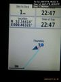
Proof. @52.3441,.4632
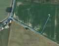
Google Earth Track


Achievements
Expeditions and Plans
| 2015-12-17 | ||
|---|---|---|
| Springfield, Illinois | Mystrsyko, Dolphintreasure | A field just off Veterans Parkway in Springfield. |
| Grand Rapids, Michigan | Mcbaneg | Next to a public path, Byron Center, MI |
| Mannheim, Germany | DODO | On a lawn next to a lake in Speyer. |
| Kassel, Germany | GeorgDerReisende | The hash lay in the Sandweg in Kassel-Jungfernkopf. |
| Cambridge, United Kingdom | Sourcerer | 2) In a field, south of West Row, south of the Mildenhall air base, Suffolk... |
| Norwich, United Kingdom | Sourcerer | 1) A road hashpoint on the B1123 west of Halesworth, Suffolk, UK. |
| Braunschweig, Germany | Someone went | Somewhere |
Sourcerer's Expedition Links
2015-12-16 52 1 - 2015-12-17 52 0 - 2015-12-18 52 0 - KML file download of Sourcerer's expeditions for use with Google Earth.