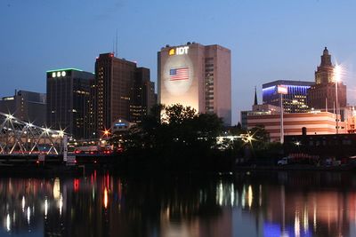
Newark, New Jersey
| Scranton, PA | Newburgh, NY | Danbury, CT |
| Philadelphia, PA (North) | Newark, New Jersey | New York, NY |
| Philadelphia, PA (South) | Atlantic City | – |
[[Category:Meetup in {{{lat}}} {{{lon}}}| ]]
The Newark graticule is at 40 N, -74 W. This may very well be the most densely populated graticule in the United States, as it includes almost the entire northern half of New Jersey, the mostly densely populated state (Census), as well as Staten Island, western sections of Brooklyn and lower Manhattan in New York, and a part of Pennsylvania northeast of Philadelphia. In addition, other than Raritan Bay, there are no large sections of water.
You can click here for Today's Location.
A Facebook Group has been created for this graticule.
Cities in this Graticule
- Newark, NJ
- Jersey City, NJ
- New Brunswick, NJ
- Trenton, NJ
- Lower Manhattan, New York, NY
- New Hope, PA
- Levittown, PA
- Langhorne, PA
- East Brunswick, NJ
Local Geohashers
- Madalis
- bjimba
- krip
- trntr

- TorsionalMetric
- Direwulf
- Jevanyn


 20px
20px

- LangleyLGLF (When @Rutgers)


- Esteban
- Science Works!

- sve
- Zubenelgenubi


- Mike
Attempted geohashes
- Main page: Meetup in 40 -74
- Saturday, July 26, 2008
- Sandburg Drive, Marlboro. Jevanyn and Zubenelgenubi made the geohash on a residential street, allowing them to mark the spot and Zubenelgenubi claims an uncommon Speed Racer geohash on a bicycle.
- Friday, July 4, 2008
- In the woods of Spring Hill Road, Amwell. Not a good place to view fireworks ;-) Zubenelgenubi made this geohash by bicycle, and uploaded a photo.
- Monday, June 30, 2008
- 17 Cornell St, West Orange. A lovely split-level, very close to Francis Byrne Golf Course - but it would take an intentional Bad Shot to achieve the Golf Geohash here. Science_Works! was there for a meetup of one(?)
- Saturday, June 28, 2008
- Brightwood Avenue, Westfield. Near Watchung Reservation. Jevanyn claims he was there with two drag-alongs, but has not yet provided proof. (start here)
- Monday, June 16, 2008
- Northbound Garden State Parkway past exit 116, off the shoulder after the Holmdel Rd. overpass. LangleyLGLF claims to have gotten the Speed Racer Achievement, but has not yet provided proof. (start here)
- Friday, June 13, 2008
- Forest Hill Rd, Staten Island, New York. There may have been a meetup at the Staten Island Mall, but no claim has been made yet. (start here)
- Thursday, June 12, 2008
- US 206, Hillsborough. Jevanyn has claimed a Cubicle Geohash honorable mention, but has not yet provided proof. (start here).
Daily Locations
A front lawn on Jefferson Street, Washington Township, Bergen county. Parkway exit 166 or 168.
Rutherford Place, North Arlington, NJ. Front lawn of the house next door to Queen of Peace High School.
Toward the end of Sandburg Drive, Morganville.
Newark Airport, in the parking lot for the Budget rental car franchise. If you take the monorail past terminal A (I think the one at the south end is A), it's just before the second stop.
Bellmans Creek, Fairview. Just to the north is an train station, I think it's Essex County light rail.
A farmer's field on Brynmore Road, New Egypt. Just north of Fort Dix.
A McMansion on Hillcroft Way, Newtown, PA. Yes, that's five PA geohashes in 18 days. Not that we don't like Pennsylvania, just sayin'.
Mantoloking, NJ. Splash! A half mile off the shore (i.e., Water Geohash).
Fifty yards off the side of I-295, near Hedding. North of exits 52 A/B. This might be a Speed Racer Geohash or nothing.
Fairway Avenue, Winder Village, south of Philadelphia. Fourth geohash in PA in 15 days.
A house on Everett Road/Crawfords Corder Road, Everett. Near Parkway exit 114.
Hazel Street, Clifton, near Parkway exit 155.
Behind a house on the corner of Van Liew Avenue and Graulich Drive, Milltown, Middlesex County.
Close to the south shore of White Meadow Lake, Rockaway Township.
Brook Park, in or near Levittown, PA. Strange: third geohash in Pennsylvania in 10 days.
Splash! The mouth of the Raritan River, between Perth Amboy and South Amboy.
- 7/12/08 - Saturday
Merck site on US Route 1, Rahway. Definitely private property. After further review, the geohash was accessible. You can get into the plant grounds without clearance, just not into any individual building. The geohash was in the middle of a street, so it was possible, though not en masse.
A house on E. Union Avenue, Bound Brook, three doors down from the church on Mountain Avenue.
Between River Road and Aquetong Rd, south of New Hope, Pennsylvania. Close to Washington Crossing State Park.
Splash! In Sandy Hook Bay, between Brooklyn and Staten Island. Should be a nice view of the Verrazano Bridge from there.
New Egypt, NJ. In the woods south of Woods Road.
North bank of the Raritan River, Piscataway.
Older locations can be looked up using the geohash calculator.
