2008-05-24
From Geohashing
Revision as of 19:45, 24 May 2008 by imported>Sydney-troz (added details for winnipeg, mb)
Expedition Archives from May 2008
Friday 23 May 2008 | Saturday 24 May 2008 | Sunday 25 May 2008
See also: Category:Meetup on 2008-05-24
The coordinates for Saturday, May 24, 2008 are:
0.1266480113970560, 0.5475331240942810
It will be the first Saturday after the algorithm was published, so there will be an xkcd meetup at 4:00pm in regions where they are reachable.
Coordinates
- Adelaide, Australia Using South Graticle Looks Best Satellite looks promising if land is private land across road looks good.
- Anchorage, Alaska Near Tanaina Peak in the Chugach State Park. The first meet up might not be heavily attended...
- Atlanta, Georgia -- In what looks like a field off of an access road near 85 south. Picnic time!
- Austin, Texas, United States 30.1266480113970560,-97.5475331240942810 - Looks private, but perhaps accessible.
- Baltimore, MD -- Coordinates are at a house on 229th st in Pasadena MD.
- Berlin, Germany Close to Erkner, reachable with public transport, on a field. Nice lakes around, worth a trip!
- Birmingham East, UK -- Private field by a main road. Should be able to get close enough for a photo.
- Boston, MA graticule -- Coordinates are in Hopedale. The exact coordinates are in someone's house, so obviously they will not be reached within a foot, but they can expect some odd passers-by on their road.
- Brisbane, Australia(South West Graticule) -- Accessible. At the foot of Mount Moon in Moogerah Peaks National Park. 2 People visted at the designated meet up time.
- Bristol, United Kingdom -- Accessible. A field in Ditcheat, Shepton Mallet.
- Carlisle, United Kingdom -- Several users reached a field of cows near Low Bentham, North Yorkshire.
- Champaign/Urbana, Illinois -- The first official meetup appears to be in a field near the intersection of N 1000 E Rd. and Cord 2350 Rd. N in Piatt County about 20 miles from Champaign-Urbana and about 50 miles from Bloomington-Normal.
- Charlotte, North Carolina -- 35.126648°, -80.547534°
- Chicago, IL -- In a field near a...something (satellite imaging is hazy) south of Woodland, IL, near the corner of E Baseline and N 1700 Rd -- near the Illinois-Indiana state line. Probably accessible, but distant -- Chicago residents may wish to use the Schaumburg graticule for Saturday's meet-up instead. (The North Shore graticule's coordinates, while technically closer, are underwater.)
- Chico, California — Actually not near Chico, but Yuba City. Looks reachable, or near enough. Convenient from Sacramento and even more so from the geocaching mega-event in Wheatland, CA.
- Cincinnati, Ohio -- Seems to be a public road leading to a few private residences. Accessible. Bringing Twister.
- Cleveland, Ohio -- Perfectly located in a large park with soccer fields and a parking lot. Bringing chess.
- Conroe, Texas - Accessible. In front of somebody's house.
- College Station, Texas - Accessible. In a pasture west of Brenham, south of Burton. However you will most likely be tresspassing and walking right by someones house.
- Denver, Colorado NW - 40.126648°,-105.547534° Middle of forest in Roosevelt National Forest on the Coney Flats four-wheel-drive road (NFSR 507), 1.5 miles from the gate at Beaver Reservoir.
- St. Louis, Missouri - Apparently just outside someone's backyard, inside a forest, in De Soto, MO.
- East Bay, California - North end of Coyote Lake County Park, accessible just off 101 near Gilroy/San Martin. Coordinates just outside park boundary, and about a 400-foot climb up from the lake, but should be able to get close.
- Edinburgh, UK -- Coordinates are in a field, east of Amisfield.
- El Paso, Texas - Accessible by 4 wheel drive, but it's in the middle of the Chihuahua desert in Mexico. Given the situation with the violence expected in Juarez this weekend, it's probably not a very good idea.
- Glasgow, UK -- Coordinates are in the middle of Galloway Forest Park.
- Groningen Drenthe, North-East of the Netherlands: 53.1266480113970560, 6.5475331240942810
- Graz, Austria Near Strallegg, eastern part of styria: 47.400246°, 15.722771°
- Grenoble, France -- Accessible. In the forest in the Vercors Mountains. Went hiking in the area recently :) About 45mins by car from Grenoble. (45.126648°, 5.547533°) [1].
- Indianapolis, IN/Bloomington, IN -- Bloomington Country club in the golf course... may be pricey/imposible
- Inland Empire, California -- Accessible. Near Vintage Park in Rancho Cucamonga.
- Lafayette, Indiana -- On W IN 47, just northwest of Lebanon.
- Leesburg, VA (also most of Jefferson & Berkeley Counties in West Virginia) -- a townhouse on the north side of Leesburg, near the corner of Clark Ct. NE and Fieldstone Dr. NE: [2]
- London West, United Kingdom -- In some woods off the A281 near Cranleigh in Surrey. Looks like there's a path going right to it! 51.1266480113970560,-0.5475331240942810
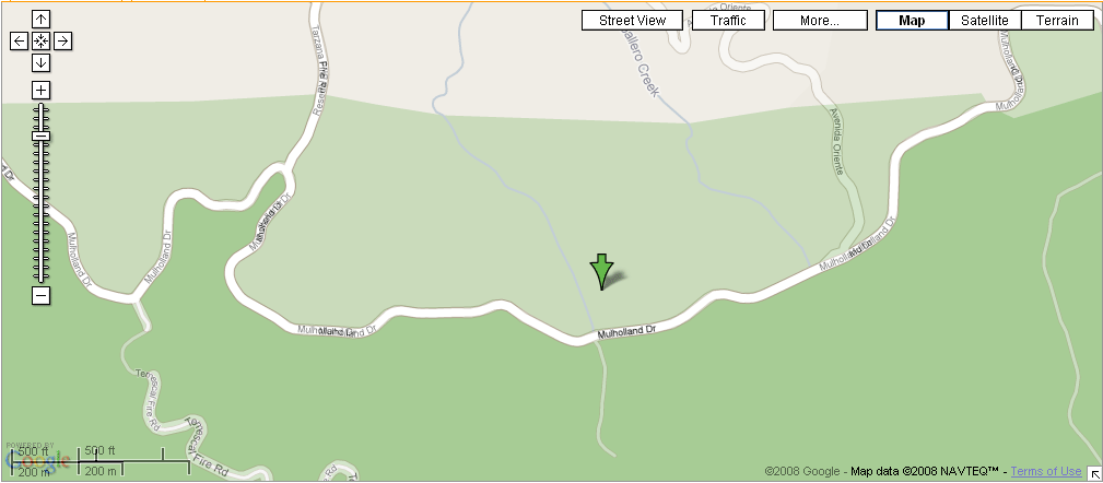
- Los Angeles, California -- Actually in West LA proper, and not too far from 'Dirt' Mulholland in Topanga State Park. Note that in the park, 'Dirt' Mulholland is a fire road and will probably be closed to vehicles. One should be able to hike/bike in from the park boundary, either on the Reseda Blvd trailhead in Tarzana or perhaps from Mulholland Dr. There is a Nike missile silo nearby. Google Maps seems to exist in two different realities as to the geography of the area; see image for details.
- Madison, Wisconsin -- The expedition to the Madison, Wisconsin geohash on 2008-05-24 falls in about 10 miles Northwest of Downtown, in the middle of a field. Definitely doable.
- Mansfield, Ohio -- crap-smack in the middle of nowhere just off a country road. Perfect spot for a meet-up.
- Montgomery, Alabama -- Middle of nowhere, a heavily wooded area next to a stream. It sounds nice enough, let's just hope we don't get chased off by a shotgun. Bring your umbrellas, it looks like rain!
- Munich, Germany -- conveniently located in the middle of the City. Meet-up will happen.
- Nashville, Tennessee -- In a field at the corner of Granny Wright Ln and (a piece of) Stewart's Ferry Pike. Probably private land.
- Newark, New Jersey -- Out in the woods/pine barrens, looks doable: 40.126648°, -74.547534° Also near the northeast border of the Philadelphia, Pennsylvania graticule.
- Newport News, Virginia -- Denbigh High School, on the roof of one of the buildings but you can get close: 37.126648°, -76.547534°
- Phoenix, Arizona -- The west valley location is on top of a mountain, so it doesn't look particularly accessible. The east valley location is in Magma, about halfway between Phoenix and Florence a copule hundred feet off the road. Should be accessible.
- Palm Beach, Florida -- I'm a recent transplant to the area. Should I worry that today's location is a mile or so south of Alligator Alley? 26.126648°, -80.547534°
- Portland, Oregon -- Molalla somewhere, it has been suggested a better meetup would be Monday's coordinates in Vancouver.
- Rochester, New York -- By the corner of Clover Street and Elmwood Avenue.
- Saskatoon, Sk - south at College and Highway 5, down ridge road 3045, just south of second farm on East side, middle of that field. Watch out for John Deeres as farmer maybe seeding!!
- Salt Lake City Utah A good hit for a mostly mountainous graticule. Only 1700ft off the road!
- San Jose, CA -- Just outside of Coyote Lake-Harvey Bear Ranch Park, possibly in SCCOSA lands.
- São Paulo, Brazil -- Possibly accessible. Looks like a point near downtown of the city of Atibaia.
- Schaumburg, IL -- Possibly accessible. Middle of some farm land north west of Route 20 and 72 intersections. I'd say meet on the north end of the point along Melms Road. 42.126648°, -88.547534°
- Seattle, Washington - Definitely accessible, public park nearby. Planning to meet at Harry Todd Park. Next to the pier looks like a reasonable place to meet.
- Sheffield, United Kingdom -- Amongst trees near some greenhouses. Might be private. Sharp bend in the Riber Road due West seems like a possible meeting place.
- Springfield, MA - Actually very convenient. Just east of the tennis courts at Blunt Park in Springfield.
- Yucca Valley, CA - Accessible. Located on the side of a ridge near a wash running north from 29 Palms Highway. Roads extend part way up the wash, the rest of the distance should be an easy hike, bring water.
- Tucson, Arizona - In Saguaro National Park-East, 2.5 miles away from nearest road access. [3]
- Vancouver, BC - in the water. However...
- Surrey, BC - coordinates just off the Trans-Canada in Langley. It looks to be right at the boundary between somebody's rear lawn and farmland. The house's address is somewhere from 24380-24399 68 Ave, Langley, BC. Probably just barely beyond the reach of transit.
- Victoria, BC - coordinates are on American soil but probably accessible, not very far from Port Angeles ferry terminal.
- Kyiv, Ukraine - coordinates are inside forest, about 700m far from nearest road.
- Dresden, Germany -- A field by Brockwitz, near Coswig. Reachable.
- Winnipeg, MB - coordinates are near the egde of a field just off a highway, just north of a small town (Altona).