Difference between revisions of "2008-07-23 52 13"
imported>Relet m (lk flashline) |
m (fix, sorry) |
||
| (8 intermediate revisions by 4 users not shown) | |||
| Line 8: | Line 8: | ||
}} | }} | ||
| − | + | {{egl|2008-07-23|52|13|text=Todays spot is near Löwenberge near Trebbin in the south of Berlin}}. Lyx and [[User:relet|I]] had planned to take the train to Thyrow (closest station within the city fare) and from there go by bike. Lyx missed the train, so I had to sadly go alone. | |
| − | : | + | <gallery> |
| + | Image:200807235213-P1010695.JPG | Thyrow station | ||
| + | </gallery> | ||
With a short detour (I don't navigate by GPS), I came close to the spot at about 4:30pm. The closest road is the Waldstraße, leading into the forest. | With a short detour (I don't navigate by GPS), I came close to the spot at about 4:30pm. The closest road is the Waldstraße, leading into the forest. | ||
| − | : | + | <gallery> |
| − | : | + | Image:200807235213-P1010696.JPG | Forest :) |
| − | : | + | Image:200807235213-P1010697.JPG | Waldstraße |
| + | Image:200807235213-P1010698.JPG | Not to be confused with "Waldweg" | ||
| + | </gallery> | ||
| − | From there, the unlabeled Steiler Weg leads steeply up to a tower that was already visible on the satellite view. It turned out to be a cellular network station. The spot is in the forest below. | + | From there, the unlabeled Steiler Weg leads steeply up to a tower that was already visible on the satellite view. It turned out to be a cellular network station. (Or maybe it's related to the nearby airport Schönhagen?) The spot is in the forest below. |
| − | : | + | <gallery> |
| − | : | + | Image:200807235213-P1010699.JPG | cell station |
| + | Image:200807235213-P1010700.JPG | The only street sign around | ||
| + | </gallery> | ||
I turned on the GPS on the top of the hill and 7 satellites led the way through the forest. | I turned on the GPS on the top of the hill and 7 satellites led the way through the forest. | ||
| − | : | + | <gallery> |
| + | Image:200807235213-P1010701.JPG | My trusty (ahem) Openmoko. :) | ||
| + | </gallery> | ||
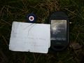
* I found the geohash location in the forest, rather close to a service path | * I found the geohash location in the forest, rather close to a service path | ||
| Line 32: | Line 40: | ||
That makes it a Geohashcacheflashline expedition. | That makes it a Geohashcacheflashline expedition. | ||
| − | : | + | <gallery> |
| − | : | + | Image:200807235213-P1010702.JPG | Geohash |
| − | + | Image:200807235213-P1010703.JPG | Geocache [http://www.geocaching.com/seek/cache_details.aspx?guid=da83efbe-46a4-4056-9413-95cc7db3cc1c GC1EFMC] - the cache was first discovered but one day later! :) | |
| − | : | + | Image:200807235213-P1010707.JPG| Geoflashline |
| + | Image:200807235213-P1010711.JPG | Walking the line. | ||
| + | </gallery> | ||
| + | |||
| + | [[Category:Expeditions]] | ||
| + | [[Category:Expeditions with photos]] | ||
| + | [[Category:Coordinates reached]] | ||
| + | |||
| + | == Gallery == | ||
| + | <gallery widths="160px" align=center> | ||
| + | </gallery> | ||
| + | {{location|DE|BB|TF}} | ||
Latest revision as of 18:53, 18 January 2022

| Wed 23 Jul 2008 in 52,13: 52.2130408, 13.1882042 geohashing.info google osm bing/os kml crox |
Todays spot is near Löwenberge near Trebbin in the south of Berlin. Lyx and I had planned to take the train to Thyrow (closest station within the city fare) and from there go by bike. Lyx missed the train, so I had to sadly go alone.
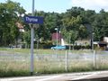
Thyrow station

With a short detour (I don't navigate by GPS), I came close to the spot at about 4:30pm. The closest road is the Waldstraße, leading into the forest.
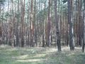
Forest :)
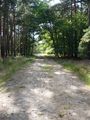
Waldstraße
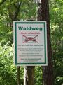
Not to be confused with "Waldweg"


From there, the unlabeled Steiler Weg leads steeply up to a tower that was already visible on the satellite view. It turned out to be a cellular network station. (Or maybe it's related to the nearby airport Schönhagen?) The spot is in the forest below.
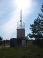
cell station
The only street sign around


I turned on the GPS on the top of the hill and 7 satellites led the way through the forest.
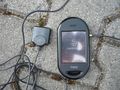
My trusty (ahem) Openmoko. :)

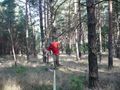
- I found the geohash location in the forest, rather close to a service path
- I hid a geocache near the spot; the cache is marked by a bull's eye. It contains the first of a series of puzzle pieces, which will be placed at consequent geohashing locations I visit.
- I set up a flashline near the spot and walked it.
That makes it a Geohashcacheflashline expedition.
Geohash
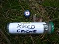
Geocache GC1EFMC - the cache was first discovered but one day later! :)
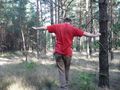
Geoflashline
Walking the line.


