Difference between revisions of "2009-12-26 48 11"
(→Omega's and zb's meet-up: typo) |
m (Replacing http://wiki.xkcd.com/geohashing/File:Zb_2009-03-28_06.jpg with :File:Zb 2009-03-28 06.jpg) |
||
| (17 intermediate revisions by 4 users not shown) | |||
| Line 6: | Line 6: | ||
__NOTOC__ | __NOTOC__ | ||
| − | Just South of runway 8R/ | + | Just South of runway 8R/26L of München's airport. Very close to the little hill that is used by spotters to look at traffic on the runway and on some of the taxiways and parts of the terminal area. |
== Participants == | == Participants == | ||
| Line 28: | Line 28: | ||
=== [[User:Omega|Omega's]] way towards the location === | === [[User:Omega|Omega's]] way towards the location === | ||
| − | ... | + | Since I wasn't sure what exactly I was going to do when I'm there, I packed quite a lot of stuff - a lot more than I needed. Electronically, I was heavily equipped. A camera that was going to annoy the hell out of during the entire expedition, an iPod touch with all the information I needed, including the exact coordinates of the hash and some Google Earth images to help me find the way, a GPS mouse and an old PDA that would navigate me to the exact spot and some miscellaneous stuff I needed like my cell phone, pager, car keys, etc. I also brought along a coke I wouldn't drink from, some Christmas cookies I wouldn't eat, a board game I wouldn't play and the new Dan Brown I wouldn't read there. |
| + | |||
| + | I chose to go by car since I'm not the kind of guy who loves riding dozens of kilometers by bike and because going by train was a tad boring in my opinion. Also, going by car is faster and more flexible, so I could have gone home whenever I wanted in case I would have gotten bored at the hash location. Plus it's good exercise for me since I made my driver's license only one and a half months ago. | ||
| + | |||
| + | Originally, I was planning on leaving at around 3 p.m. so I could make it by 4 p.m. to see if anyone visits the Saturday meetings. But at noon when I checked the Munich graticule, I noticed [[User:Zb|Zb]] had created an expedition page, planned his own trip and had already departed to the hash location by bike! So I quickly packed all my stuff, took a quick shower and jumped into the car and rode off to my first geohash adventure! | ||
| + | |||
| + | The ride wasn't very exciting, it was a bit faster than I had expected (half an hour from my home slightly to the east of Munich), so I arrived at the correct street at half past one. | ||
| + | |||
| + | Now to find the spot, hopefully before Zb arrives! I activate the GPS program of my PDA that allows me to view my exact coordinates. Annoyed at how the program displays the coordinates in minutes and seconds of angles instead of in decimals, I quickly convert the decimals into minutes and seconds with my iPod. I already knew the spot was going to be in that muddy field - after all, I had images of the hash and I read [[User:Zb|Zb]]'s comments of this page earlier. According to Zb, I should run one third into the field after the thirteenth tree. I park my car (I'm still not sure if parking there was allowed...) and run off into the field after the thirteenth tree, hoping to get as little mud on my shoes before finding the spot. Well, turns out I had to wander around for five minutes or something, one step at a time, wondering why the spot was so far off of Zb's estimation. The explanation was simple: Zb counted trees from the other direction so I entered the field way off the hash. Eventually I find the hash and put a stick I picked up earlier into the spot to mark it. I quickly leave the field with UNBELIEVABLY muddy shoes (the mud on my shoes weighs more than my shoes do... ^^), take a deep breath, stare at the stick from a distance for less than a minute when a bicycle arrives at the scene whose [[User:Zb|rider]] keeps staring in the same direction I'm staring... | ||
| + | |||
| + | ''GOTO [[User:Omega|Omega's]] and [[User:Zb|zb's]] meet-up'' | ||
=== [[User:Zb|zb's]] way towards the location === | === [[User:Zb|zb's]] way towards the location === | ||
| − | I charged the camera batteries, made sure I really had put on warm socks, made two liters of tea and some sandwiches. I can't tell you how great it felt to finally take out my good bike again for a longer trip after having fixed it [[2009-12-13 48 11|two weekends ago]] instead of going geohashing with [[User:Dawidi|dawidi]], [[User:Thepiguy|thepiguy]] and [[User:srs0|srs0]]. Seriously, it had been broken for almost a year now and after [ | + | I charged the camera batteries, made sure I really had put on warm socks, made two liters of tea and some sandwiches. I can't tell you how great it felt to finally take out my good bike again for a longer trip after having fixed it [[2009-12-13 48 11|two weekends ago]] instead of going geohashing with [[User:Dawidi|dawidi]], [[User:Thepiguy|thepiguy]] and [[User:srs0|srs0]]. Seriously, it had been broken for almost a year now and after [[:File:Zb 2009-03-28 06.jpg|my other bike]] had failed as well recently, I had finally taken the effort to take apart the hub gear of my good bike that had suffered ''catastrophic failure'', as wreckage investigators would probably say. |
I left the City of Munich through its Eastern suburbs, crossed the [http://de.wikipedia.org/wiki/Ismaninger_Speichersee Ismaning Reservoir] and went further North through the Finsing Bog, past the [http://en.wikipedia.org/wiki/Ismaning_radio_transmitter large radio towers near Ismaning] and on towards München's airport. | I left the City of Munich through its Eastern suburbs, crossed the [http://de.wikipedia.org/wiki/Ismaninger_Speichersee Ismaning Reservoir] and went further North through the Finsing Bog, past the [http://en.wikipedia.org/wiki/Ismaning_radio_transmitter large radio towers near Ismaning] and on towards München's airport. | ||
| − | + | === [[User:Omega|Omega's]] and [[User:Zb|zb's]] meet-up === | |
| + | |||
| + | ''Cont'd from [[User:Omega|Omega's]] way towards the location'' | ||
| − | + | ... and wonders if this other person at the side of the street might actually be a fellow geohasher? The person on the bike still needed 0.5 s to allow his mind to de-select the get-there-mode and switch over to look-closer mode (similar to the process of zooming in on an online satellite image on a slow dial-up line). He made a U-turn 20 m down the road and approached the fellow geohasher again, wondering if they had already met before. They hadn't, so the nice suprise was even bigger. | |
| − | + | Both geohashers went onto the semi-frozen and semi-muddy field to celebrate the success. Then, they tried to put the dirt away from their shoes and onto the street and went up the hill that was created for plane spotters. They did like everyone else on the hill, i.e. they spotted planes and took pictures of planes for a while -- but they felt ''just slightly'' under-equipped when they saw the huge cameras the ''real'' plane spotters were aiming at the traffic arriving and departing runway 8R. You could tell that the two geohashers clearly were not the pros among the plane-spotting crowd. However, they aced in achieving a meet-up. | |
| − | + | In between spotting planes, they re-checked every couple of minutes if other geohashers had arrived at the field that was easily visible from the hill, too. None were found, though. | |
| − | + | == [[User:Zb|zb's]] Photos == | |
<!-- Insert pictures between the gallery tags using the following format: | <!-- Insert pictures between the gallery tags using the following format: | ||
| Line 53: | Line 65: | ||
--> | --> | ||
| + | Still at home, just before getting on the bike: | ||
| + | |||
| + | <gallery perrow="4"> | ||
| + | Image:2009-12-26 48 11 zb 0018.jpg | Information provided by the mighty internet... | ||
| + | Image:2009-12-26 48 11 zb 0016.jpg | ... and reality as seen through the kitchen window agree. | ||
| + | </gallery> | ||
| + | |||
| + | |||
| + | The route to the coordinates at München's new airport took me through Riem, where the old airport used to be until 1992. | ||
| + | |||
| + | <gallery perrow="4"> | ||
| + | Image:2009-12-26 48 11 zb 0025.jpg | The tower and an old terminal building are still there. | ||
| + | Image:2009-12-26 48 11 zb 0026.jpg | It was a really cool idea to leave a bit of the old runway in its place. | ||
| + | Image:2009-12-26 48 11 zb 0027.jpg | An air cargo container is also still at the old airport. | ||
| + | </gallery> | ||
| + | |||
| + | |||
| + | ... and on through Feldkirchen. | ||
| + | |||
| + | <gallery perrow="4"> | ||
| + | Image:2009-12-26 48 11 zb 0030.jpg | There are some serious gasoline and diesel tanks in Feldkirchen. | ||
| + | Image:2009-12-26 48 11 zb 0031.jpg | Also, there is a [http://www.lfu.bayern.de/wasser/fachinformationen/wgs_pipelines/pic/pipelines_gr.jpg pipeline for jet fuel from Burghausen via Feldkirchen to the new airport]. | ||
| + | Image:2009-12-26 48 11 zb 0032.jpg | A suburban train passes some storage buildings in Feldkirchen. | ||
| + | </gallery> | ||
| + | |||
| + | |||
| + | Modern achievements near Feldkirchen and Heimstetten. | ||
| + | |||
| + | <gallery perrow="4"> | ||
| + | Image:2009-12-26 48 11 zb 0034.jpg | I remember the view when these buildings had not yet been built... | ||
| + | Image:2009-12-26 48 11 zb 0036.jpg | ... and the word that now comes to mind is: ''Impact!'' | ||
| + | Image:2009-12-26 48 11 zb 0038.jpg | This place has not yet been impacted. The sign silently says that plans for an impact have been around for quite some years, though. | ||
| + | </gallery> | ||
| + | |||
| + | |||
| + | And on to the big reservoir near Ismaning and Neufinsing. | ||
| + | |||
| + | <gallery perrow="4"> | ||
| + | Image:2009-12-26 48 11 zb 0040.jpg | Power plant at the end of the reservoir in Neufinsing. | ||
| + | Image:2009-12-26 48 11 zb 0043.jpg | Looking the other way towards München's North. | ||
| + | Image:2009-12-26 48 11 zb 0041.jpg | The big artificial lake also is home to many birds, some of them are even quite rare. | ||
| + | Image:2009-12-26 48 11 zb 0042.jpg | The Beastie Boys might use rhymes like these: ''These people have all the birds on their lists / That's why we call them ornithologists.'' | ||
| + | </gallery> | ||
| + | |||
| + | |||
| + | North of the Ismaning Reservoir, there is quite some water in the ground. Therefore the name: ''Finsingermoos'' (Finsing Bog). A lot of water in the ground means good electrical conductivity -- the ideal spot for radio transmitters. The route also took me along parts of the pipeline for jet fuel and brought me close to the location of my [[2008-05-29 48 11|second ever geohash]]. | ||
| − | < | + | <gallery perrow="4"> |
| − | [[ | + | Image:2009-12-26 48 11 zb 0092.jpg | Bus stop ''Hinteres Finsingermoos''. Road Sign towards the radio towers. |
| + | Image:2009-12-26 48 11 zb 0095.jpg | There's even a street named after the Big Transmitter. | ||
| + | Image:2009-12-26 48 11 zb 0044.jpg | Large AM antenna near Ismaning. | ||
| + | Image:2009-12-26 48 11 zb 0045.jpg | More radio towers. | ||
| + | Image:2009-12-26 48 11 zb 0094.jpg | Farming grounds next to huge radio towers. | ||
| + | Image:2009-12-26 48 11 zb 0091.jpg | Pipeline for jet fuel. | ||
| + | Image:2009-12-26 48 11 zb 0046.jpg | [[2008-05-29 48 11]] was right next to this huge pylon. | ||
| + | </gallery> | ||
| − | |||
| − | |||
| − | |||
| − | |||
| − | < | + | The Meetup, yay! |
| − | [[ | + | |
| − | -- | + | <gallery perrow="4"> |
| − | [[ | + | Image:2009-12-26 48 11 zb 0049.jpg | Both geohashers sport The Stupid Grin<sup>tm</sup> |
| − | [[ | + | Image:2009-12-26 48 11 zb 0047.jpg | [[User:Omega|Omega's]] marker in the foreground, München tower in the background. (GIMPed for better contrast) |
| − | + | Image:2009-12-26 48 11 zb 0048.jpg | The amount of mud on the shoes becomes less as the amount of mud on the road increases. The hill that overlooks the airport can be seen in the background. | |
| − | --> | + | </gallery> |
| − | + | ||
| − | < | + | |
| − | + | Spotting planes. | |
| − | --> | + | |
| + | <gallery perrow="3"> | ||
| + | Image:2009-12-26 48 11 zb 0079.jpg | Rotate! | ||
| + | Image:2009-12-26 48 11 zb 0059.jpg | Gear Up! | ||
| + | Image:2009-12-26 48 11 zb 0083.jpg | Small planes may turn South as soon as they are in the air, just halfway down the runway. This one flies pretty much right over the geohash location. Everyone on board is probably totally unaware of their achievement. | ||
| + | Image:2009-12-26 48 11 zb 0085.jpg | Found the paper from a fortune cookie on the hill. | ||
| + | Image:2009-12-26 48 11 zb 0086.jpg | There really can't be a better phrase in a fortune cookie on a hill where plane spotters do their thing... | ||
| + | Image:2009-12-26 48 11 zb 0087.jpg | [[User:Omega|Omega]] earns the Geotrash Achievement. It's nice that they have the same trash baskets on the hill as they have in the terminal. | ||
| + | </gallery> | ||
| + | |||
| + | |||
| + | Back home. | ||
| + | |||
| + | <gallery perrow="3"> | ||
| + | Image:2009-12-26 48 11 zb 0090.jpg | Biking along the ''Goldach'' (= gold creek). Even on a short day around winter solstice, you don't need much imagination to understand the name of the creek. | ||
| + | Image:2009-12-26 48 11 zb 0099.jpg | Another nice detail along the way: BMW has a racetrack... | ||
| + | Image:2009-12-26 48 11 zb 0102.jpg | ... just North of Ismaning Reservoir. This is where they test drive their new cars. | ||
| + | Image:2009-12-26 48 11 zb 0097.jpg | The moon appeared brighter and brighter... | ||
| + | Image:2009-12-26 48 11 zb 0101.jpg | ... as the sun set while I rode back along the Ismaning Reservoir. | ||
| + | Image:2009-12-26 48 11 zb 0103.jpg | Looking South towards the Alps. The big one on the right is the Zugspitze that became [[2009-06-07 47 10|famous earlier this year]]. | ||
| + | </gallery> | ||
| + | |||
| + | <gallery perrow="3"> | ||
| + | Image:2009-12-26 48 11 zb 0105.jpg | One of my favourite signs of all times. | ||
| + | Image:2009-12-26 48 11 zb 0106.jpg | Even though I know Germany ever since I was born, some things about my country's culture still don't fail to surprise me... | ||
| + | </gallery> | ||
| + | |||
| + | |||
| + | Revisited: After sunset, some things on the way back looked a lot more interesting than during the day. Like, Las Vegas looks better at night, too, right? | ||
| + | |||
| + | <gallery perrow="2"> | ||
| + | Image:2009-12-26 48 11 zb 0034.jpg | Early afternoon. | ||
| + | Image:2009-12-26 48 11 zb 0110.jpg | At night. | ||
| + | </gallery> | ||
| + | |||
| + | <gallery perrow="2"> | ||
| + | Image:2009-12-26 48 11 zb 0032.jpg | Early afternoon. | ||
| + | Image:2009-12-26 48 11 zb 0112.jpg | At night. | ||
| + | </gallery> | ||
| + | |||
| + | <gallery perrow="2"> | ||
| + | Image:2009-12-26 48 11 zb 0031.jpg | Early afternoon. | ||
| + | Image:2009-12-26 48 11 zb 0115.jpg | At night. | ||
| + | </gallery> | ||
| + | |||
| + | <gallery perrow="2"> | ||
| + | Image:2009-12-26 48 11 zb 0018.jpg | It even had become warmer... | ||
| + | Image:2009-12-26 48 11 zb 0125.jpg | ... after sunset. | ||
| + | </gallery> | ||
| − | |||
| − | |||
| − | |||
| − | |||
| − | |||
| − | |||
| − | |||
| − | |||
[[Category:Expeditions]] | [[Category:Expeditions]] | ||
| + | [[Category:Expedition without GPS]] | ||
[[Category:Coordinates reached]] | [[Category:Coordinates reached]] | ||
| + | [[Category:Expeditions with photos]] | ||
| + | {{location|DE|BY|ED}} | ||
Latest revision as of 10:59, 19 February 2020
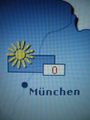
| Sat 26 Dec 2009 in 48,11: 48.3387626, 11.7905928 geohashing.info google osm bing/os kml crox |
Just South of runway 8R/26L of München's airport. Very close to the little hill that is used by spotters to look at traffic on the runway and on some of the taxiways and parts of the terminal area.
Participants
zb. Anyone else?
Omega. It'll be my first geohash since I've read the comic yesterday evening. =P
Plans
zb will wear warm socks and will try to get there by bike from his home in München. ETA likely between 2:00 or 2:30 pm, but this is a rough guess. (Esitimated, likely, guess: how vague can it get?) --Zb 10:39, 26 December 2009 (UTC)
Omega will go by car, no unneeded risks on my first try. I was planning on being there by 4 p.m. but I'll pack my things and go within the next two hours (by 2 p.m.) and help Zb find the spot with some GPS. ^^
Expedition
No GPS, so I need to memorize this: On a field, W of the 13th tree along the street from the airport; 1/3 into the field. And off I go. --Zb 10:39, 26 December 2009 (UTC)
The no-batteries-just-landmarks approach would have worked, as was confirmed by Omega's GPS. He had put a marker into the spot just some minutes before I got there. -> Success! And even a meet-up! Yay.
Omega's way towards the location
Since I wasn't sure what exactly I was going to do when I'm there, I packed quite a lot of stuff - a lot more than I needed. Electronically, I was heavily equipped. A camera that was going to annoy the hell out of during the entire expedition, an iPod touch with all the information I needed, including the exact coordinates of the hash and some Google Earth images to help me find the way, a GPS mouse and an old PDA that would navigate me to the exact spot and some miscellaneous stuff I needed like my cell phone, pager, car keys, etc. I also brought along a coke I wouldn't drink from, some Christmas cookies I wouldn't eat, a board game I wouldn't play and the new Dan Brown I wouldn't read there.
I chose to go by car since I'm not the kind of guy who loves riding dozens of kilometers by bike and because going by train was a tad boring in my opinion. Also, going by car is faster and more flexible, so I could have gone home whenever I wanted in case I would have gotten bored at the hash location. Plus it's good exercise for me since I made my driver's license only one and a half months ago.
Originally, I was planning on leaving at around 3 p.m. so I could make it by 4 p.m. to see if anyone visits the Saturday meetings. But at noon when I checked the Munich graticule, I noticed Zb had created an expedition page, planned his own trip and had already departed to the hash location by bike! So I quickly packed all my stuff, took a quick shower and jumped into the car and rode off to my first geohash adventure!
The ride wasn't very exciting, it was a bit faster than I had expected (half an hour from my home slightly to the east of Munich), so I arrived at the correct street at half past one.
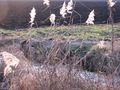
Now to find the spot, hopefully before Zb arrives! I activate the GPS program of my PDA that allows me to view my exact coordinates. Annoyed at how the program displays the coordinates in minutes and seconds of angles instead of in decimals, I quickly convert the decimals into minutes and seconds with my iPod. I already knew the spot was going to be in that muddy field - after all, I had images of the hash and I read Zb's comments of this page earlier. According to Zb, I should run one third into the field after the thirteenth tree. I park my car (I'm still not sure if parking there was allowed...) and run off into the field after the thirteenth tree, hoping to get as little mud on my shoes before finding the spot. Well, turns out I had to wander around for five minutes or something, one step at a time, wondering why the spot was so far off of Zb's estimation. The explanation was simple: Zb counted trees from the other direction so I entered the field way off the hash. Eventually I find the hash and put a stick I picked up earlier into the spot to mark it. I quickly leave the field with UNBELIEVABLY muddy shoes (the mud on my shoes weighs more than my shoes do... ^^), take a deep breath, stare at the stick from a distance for less than a minute when a bicycle arrives at the scene whose rider keeps staring in the same direction I'm staring...
zb's way towards the location
I charged the camera batteries, made sure I really had put on warm socks, made two liters of tea and some sandwiches. I can't tell you how great it felt to finally take out my good bike again for a longer trip after having fixed it two weekends ago instead of going geohashing with dawidi, thepiguy and srs0. Seriously, it had been broken for almost a year now and after my other bike had failed as well recently, I had finally taken the effort to take apart the hub gear of my good bike that had suffered catastrophic failure, as wreckage investigators would probably say.
I left the City of Munich through its Eastern suburbs, crossed the Ismaning Reservoir and went further North through the Finsing Bog, past the large radio towers near Ismaning and on towards München's airport.
Omega's and zb's meet-up
Cont'd from Omega's way towards the location
... and wonders if this other person at the side of the street might actually be a fellow geohasher? The person on the bike still needed 0.5 s to allow his mind to de-select the get-there-mode and switch over to look-closer mode (similar to the process of zooming in on an online satellite image on a slow dial-up line). He made a U-turn 20 m down the road and approached the fellow geohasher again, wondering if they had already met before. They hadn't, so the nice suprise was even bigger.
Both geohashers went onto the semi-frozen and semi-muddy field to celebrate the success. Then, they tried to put the dirt away from their shoes and onto the street and went up the hill that was created for plane spotters. They did like everyone else on the hill, i.e. they spotted planes and took pictures of planes for a while -- but they felt just slightly under-equipped when they saw the huge cameras the real plane spotters were aiming at the traffic arriving and departing runway 8R. You could tell that the two geohashers clearly were not the pros among the plane-spotting crowd. However, they aced in achieving a meet-up.
In between spotting planes, they re-checked every couple of minutes if other geohashers had arrived at the field that was easily visible from the hill, too. None were found, though.
zb's Photos
Still at home, just before getting on the bike:
Information provided by the mighty internet...
... and reality as seen through the kitchen window agree.


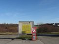
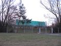
The route to the coordinates at München's new airport took me through Riem, where the old airport used to be until 1992.
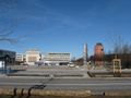
The tower and an old terminal building are still there.
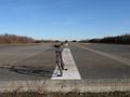
It was a really cool idea to leave a bit of the old runway in its place.
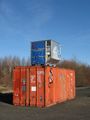
An air cargo container is also still at the old airport.


... and on through Feldkirchen.

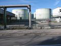
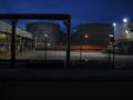
There are some serious gasoline and diesel tanks in Feldkirchen.
Also, there is a pipeline for jet fuel from Burghausen via Feldkirchen to the new airport.
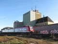
A suburban train passes some storage buildings in Feldkirchen.


Modern achievements near Feldkirchen and Heimstetten.
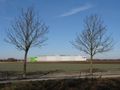
I remember the view when these buildings had not yet been built...
... and the word that now comes to mind is: Impact!
This place has not yet been impacted. The sign silently says that plans for an impact have been around for quite some years, though.


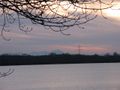
And on to the big reservoir near Ismaning and Neufinsing.
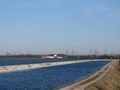
Power plant at the end of the reservoir in Neufinsing.
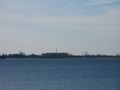
Looking the other way towards München's North.
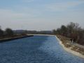
The big artificial lake also is home to many birds, some of them are even quite rare.

The Beastie Boys might use rhymes like these: These people have all the birds on their lists / That's why we call them ornithologists.


North of the Ismaning Reservoir, there is quite some water in the ground. Therefore the name: Finsingermoos (Finsing Bog). A lot of water in the ground means good electrical conductivity -- the ideal spot for radio transmitters. The route also took me along parts of the pipeline for jet fuel and brought me close to the location of my second ever geohash.
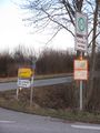
Bus stop Hinteres Finsingermoos. Road Sign towards the radio towers.
There's even a street named after the Big Transmitter.
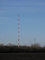
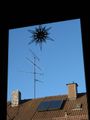
Large AM antenna near Ismaning.
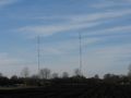
More radio towers.
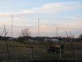
Farming grounds next to huge radio towers.
Pipeline for jet fuel.
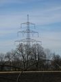
2008-05-29 48 11 was right next to this huge pylon.


The Meetup, yay!
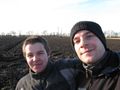
Both geohashers sport The Stupid Grintm
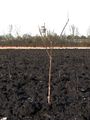
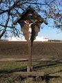
Omega's marker in the foreground, München tower in the background. (GIMPed for better contrast)
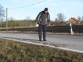
The amount of mud on the shoes becomes less as the amount of mud on the road increases. The hill that overlooks the airport can be seen in the background.


Spotting planes.
Rotate!
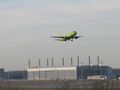
Gear Up!
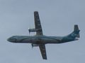
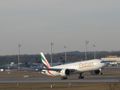
Small planes may turn South as soon as they are in the air, just halfway down the runway. This one flies pretty much right over the geohash location. Everyone on board is probably totally unaware of their achievement.
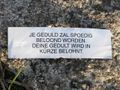
Found the paper from a fortune cookie on the hill.

There really can't be a better phrase in a fortune cookie on a hill where plane spotters do their thing...
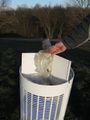
Omega earns the Geotrash Achievement. It's nice that they have the same trash baskets on the hill as they have in the terminal.


Back home.
Biking along the Goldach (= gold creek). Even on a short day around winter solstice, you don't need much imagination to understand the name of the creek.
Another nice detail along the way: BMW has a racetrack...
... just North of Ismaning Reservoir. This is where they test drive their new cars.
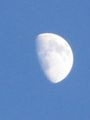
The moon appeared brighter and brighter...
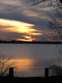
... as the sun set while I rode back along the Ismaning Reservoir.
Looking South towards the Alps. The big one on the right is the Zugspitze that became famous earlier this year.


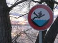
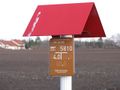
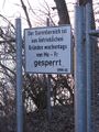
One of my favourite signs of all times.
Even though I know Germany ever since I was born, some things about my country's culture still don't fail to surprise me...


Revisited: After sunset, some things on the way back looked a lot more interesting than during the day. Like, Las Vegas looks better at night, too, right?
Early afternoon.
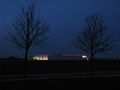
At night.

Early afternoon.
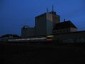
At night.

Early afternoon.
At night.

It even had become warmer...
... after sunset.
