Difference between revisions of "2010-09-24 51 1"
From Geohashing
imported>Sourcerer |
imported>Sourcerer |
||
| Line 1: | Line 1: | ||
| − | |||
| − | |||
| − | |||
| − | |||
{{meetup graticule | {{meetup graticule | ||
| lat=51 | | lat=51 | ||
| Line 8: | Line 4: | ||
| date=2010-09-24 | | date=2010-09-24 | ||
| graticule_name=Canterbury | | graticule_name=Canterbury | ||
| − | | graticule_link=Canterbury, United Kingdom}} | + | | graticule_link=Canterbury, United Kingdom |
| + | }} | ||
| + | |||
| + | == Location == | ||
| + | |||
| + | Hash 1 of 5: About a mile east of the village of East Bergholt and just south of the A12. It was in a sheep field. | ||
== Participants == | == Participants == | ||
| Line 26: | Line 27: | ||
== Photo Gallery == | == Photo Gallery == | ||
| − | <gallery | + | <gallery> |
Image:2010-09-24_51_1_Sourcerer_1.JPG|Sheep Field at Dusk | Image:2010-09-24_51_1_Sourcerer_1.JPG|Sheep Field at Dusk | ||
Image:2010-09-24_51_1_Sourcerer_2.JPG|Sheep Field at Dusk | Image:2010-09-24_51_1_Sourcerer_2.JPG|Sheep Field at Dusk | ||
| Line 48: | Line 49: | ||
{{expedition summaries|2010-09-24}} | {{expedition summaries|2010-09-24}} | ||
| + | [[Category:Expeditions]] | ||
[[Category:Expeditions with photos]] | [[Category:Expeditions with photos]] | ||
[[Category:Coordinates reached]] | [[Category:Coordinates reached]] | ||
| − | |||
| − | |||
Revision as of 14:50, 22 August 2012
| Fri 24 Sep 2010 in Canterbury: 51.9829422, 1.0410459 geohashing.info google osm bing/os kml crox |
Contents
Location
Hash 1 of 5: About a mile east of the village of East Bergholt and just south of the A12. It was in a sheep field.
Participants
Sourcerer - Arrived at about 18:56
MagicIan - Arrived somewhat later and did not meet Sourcerer.
Expedition
Sourcerer (Neil) made a 300 mile journey and took in five hashpoints. This was the first. It was a straightforward circular country walk past fields, across a stream and through a wood.
Tracklog
The track is logged here at Wikiloc.
Photo Gallery
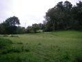
Sheep Field at Dusk
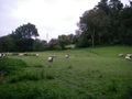
Sheep Field at Dusk
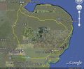
Google Earth Image
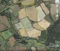
Google Earth Walk Track


Achievements
Neil believes this is the first documented expedition in the Canterbury graticule. It seems odd to claim this by visiting a point in Suffolk.
Other geohashing expeditions on the same day
Expeditions and Plans
| 2010-09-24 | ||
|---|---|---|
| Crestview, Florida | Powertool | In someone's backyard. |
| Plainview, Texas | Redassag02 | Just on the side of the road |
| Allentown, Pennsylvania | Candida Nashe | Southeast of Kutztown, Pennsylvania |
| Cleveland, Ohio | jSchleappi, Teh Lauren | East Cleveland |
| Portland, Oregon | Michael5000, Jim | Somebody's driveway, in Sellwood. |
| Montréal, Québec | Alana, Danielle, Wesley, David | located next to a building on Avenue Fielding in Montréal. |
| Landshut, Germany | dawidi | In the Danube river south of Sinzing, a few kilometers upstream from Regens... |
| Vancouver, British Columbia | user:thepiguy | In the forest north of Roberts Creek. |
| Nowy Sącz, Poland | Felinator | In small forest in Wieliczka. |
| Erfurt, Germany | Mampfred, Rincewind | Right in the middle of Erfurt next to the University of Applied Science. Pe... |
| London West, United Kingdom | Sourcerer | 3) A few hundred metres west of the village of Buckland. |
| London East, United Kingdom | Sourcerer | 2) A few hundred metres north of the village of Anstey. |
| Canterbury, United Kingdom | Sourcerer, MagicIan | 1) About a mile east of the village of East Bergholt and just south of the ... |
| Northampton, United Kingdom | Sourcerer | 4) Between the goal posts on a mini soccer field in a children's play area.... |
| Cambridge, United Kingdom | Sourcerer | 5) 90 seconds before midnight - a grassy area between two houses east of Bo... |
| Edmonton, Alberta | Phi-loci-raptor, b cereus | Just back from work up north, fighting nightshift-lag, hangovers and racing... |