Difference between revisions of "2010-12-26 -36 174"
imported>Krintar (→Location) |
m (fix, sorry) |
||
| (19 intermediate revisions by 6 users not shown) | |||
| Line 1: | Line 1: | ||
| − | |||
| − | |||
| − | |||
| − | |||
| − | |||
| − | |||
| − | |||
| − | |||
| − | |||
| − | |||
{{meetup graticule | {{meetup graticule | ||
| lat=-36 | | lat=-36 | ||
| Line 15: | Line 5: | ||
}} | }} | ||
| − | + | ||
| − | |||
== Location == | == Location == | ||
| − | + | By Google maps it appears to be at the base of a street light in a median strip out in Albany. | |
== Participants == | == Participants == | ||
| − | + | *[[User:JimmyNZ|JimmyNZ]] | |
| + | |||
| + | *[[User:Greenslime|Greenslime]] | ||
| + | |||
| + | *[[User:Krintar|Krintar]] | ||
== Plans == | == Plans == | ||
| − | + | [[User:JimmyNZ|JimmyNZ]],[[User:Greenslime|Greenslime]]: I was all keen to drive out, | |
| + | snap a pic then return home, but with Greenslime prodding me we hatched a very devious plan. | ||
| + | |||
| + | Basically we decided to run to the hash point via one route; stop and take photos; | ||
| + | and then walk up to a bus depot; catch a ride back on a different route; | ||
| + | and finally run the remainder from where the bus dropped us off to our home. | ||
| + | |||
| + | [[User:Krintar|Krintar]]:Everyone I talked to about having a geohashing adventure seemed lazy and uninterested, so I was on the brink of deciding to just leave my first hash for some other day... then I noticed the location. | ||
| + | 'Munroe Lane?' I thought to myself, 'I could do my first hash in Munroe Lane? Awesome.' So I decided to go ahead anyway. | ||
| + | |||
| + | I'll be there around 4pm; hope to see someone else. | ||
== Expedition == | == Expedition == | ||
| − | + | [[User:JimmyNZ|JimmyNZ]],[[User:Greenslime|Greenslime]]:So after carefully planning our route | |
| + | over a cup of coffee, it was still early and with yesterday being | ||
| + | Xmas we were both a little too full of food. After packing supplies, including a | ||
| + | couple of Greenslimes' homemade fruit mince pies (yum!!) we took off on our little | ||
| + | jog. It kinda sucks that we get out of our house and we're facing | ||
| + | a steep hill for the next few kilometers. What a rude wake up. | ||
| + | |||
| + | A little time passes, along with 10.17 km (or 6.3 miles for you imperial folk) and we reach the hashpoint. We catch our breaths, sit down for a little hash pie, snap some photos, pick up some trash (It was an AC/DC cd: who throws that stuff out - black ice is a classic!!) for a further geotrash award then amble up to the bus stop. | ||
| + | |||
| + | After only a 4 minute wait for a bus (believe me in New Zealand that's what we call amazing) we jump on, pay a small fortune and sit back in air conditioned comfort for a little siesta. | ||
| + | |||
| + | Once we're ejected it's only a short 3.3 km run (~2 miles folks) until we reach home. | ||
| + | |||
| + | Job done, and a successful Tron Achievement. | ||
| + | |||
| + | |||
| + | [[User:Krintar|Krintar]]: Managed to snag a lift out there; parked on Davies Dr. and walked down to the hash point. Not terribly complicated for a first time out, though in retrospect I wish I had thought to set myself up for a few achievements. | ||
| + | |||
| + | I did manage to convince one of my friends to come out and meet me there, at least. | ||
| + | We agreed that it was convenient to have a lamppost marking the hash point. | ||
| + | Snapped a few pictures, hey presto, time to go home. | ||
== Tracklog == | == Tracklog == | ||
| − | + | [[User:JimmyNZ|JimmyNZ]],[[User:Greenslime|Greenslime]]: http://www.everytrail.com/view_trip.php?trip_id=915946 | |
== Photos == | == Photos == | ||
| − | |||
| − | |||
| − | |||
<gallery perrow="5"> | <gallery perrow="5"> | ||
| + | |||
| + | |||
| + | File:2010-12-26 -36 174 Hash point.jpg|Hash from a distance | ||
| + | File:2010-12-26_-36_174_pie.jpg|Home-made Xmas mince pies | ||
| + | File:2010-12-26 -36 174 Jim Pie.jpg|JimmyNZ and Pie | ||
| + | File:2010-12-26 -36 174 K pie.jpg|Greenslime and Pie | ||
| + | File:2010-12-26 -36 174 Jim hash point.jpg|JimmyNZ with trash | ||
| + | File:2010-12-26 -36 174 xkcd.jpg|Maybe Krintar will see our tag | ||
| + | File:2010-12-26 -36 174 bus.jpg|Bus trip home | ||
| + | </gallery> | ||
| + | |||
| + | <gallery perrow="5"> | ||
| + | File:2010-12-26 -36 174 Street sign.jpg|The hash was on Munroe Lane | ||
| + | File:2010-12-26 -36 174 Co-ordinates.jpg|GPS at the hash point | ||
| + | File:2010-12-26 -36 174 Krintar.jpg|Krintar at the hash | ||
| + | File:2010-12-26 -36 174 Kerry.jpg|Friend Kerry at the hash | ||
</gallery> | </gallery> | ||
== Achievements == | == Achievements == | ||
{{#vardefine:ribbonwidth|800px}} | {{#vardefine:ribbonwidth|800px}} | ||
| − | |||
| + | {{Tron | ||
| + | | latitude = -36 | ||
| + | | longitude = 174 | ||
| + | | date = 2010-12-26 | ||
| + | | tracklog = http://www.everytrail.com/view_trip.php?trip_id=915946 | ||
| + | | possessive = their | ||
| + | | name = [[User:JimmyNZ|JimmyNZ]] and [[User:Greenslime|Greenslime]] | ||
| + | |||
| + | |||
| + | }} | ||
| + | {{Ribbon | ||
| + | |icon = EasyAsPi.PNG | ||
| + | |color = deeppink | ||
| + | |user = [[User:JimmyNZ|JimmyNZ]] and [[User:Greenslime|Greenslime]] | ||
| + | |achievement = [[Pie Geohash]] Achievement | ||
| + | |action = baking Xmas fruit-mince pie for other people to degustate at the {{egl|2010-12-26|-36|174|text=(-36, 174) geohash}} on [[2010-12-26 -36 174|2010-12-26]] | ||
| + | |image = 2010-12-26_-36_174_Jim_Pie.jpg | ||
| + | |category = Pie geohash achievement | ||
| + | |expedition = [[2010-12-26 -36 174]] | ||
| + | }} | ||
| + | |||
| + | {{Geotrash | ||
| + | | latitude = -36 | ||
| + | | longitude = 174 | ||
| + | | date = 2010-12-26 | ||
| + | | name = [[User:JimmyNZ|JimmyNZ]] and [[User:Greenslime|Greenslime]] | ||
| + | | image = 2010-12-26_-36_174_Jim_hash_point.jpg | ||
| + | }} | ||
| − | + | {{Walk geohash | |
| − | + | | latitude = -36 | |
| − | [[ | + | | longitude = 174 |
| + | | date = 2010-12-26 | ||
| + | | name = [[User:JimmyNZ|JimmyNZ]] and [[User:Greenslime|Greenslime]] | ||
| + | | distance = 13.3 km | ||
| − | + | }} | |
| − | |||
| − | |||
| − | |||
| − | + | {{Public transport geohash | |
| + | | latitude = -36 | ||
| + | | longitude = 174 | ||
| + | | date = 2010-12-26 | ||
| + | | busline = Northern Express 895 bus - Albany to Smales Farm | ||
| + | | name = [[User:JimmyNZ|JimmyNZ]] and [[User:Greenslime|Greenslime]] | ||
| + | | image = 2010-12-26_-36_174_bus.jpg | ||
| + | |||
| + | }} | ||
| + | |||
| + | {{land geohash | ||
| + | |||
| + | | latitude = -36 | ||
| + | | longitude = 174 | ||
| + | | date = 2010-12-26 | ||
| + | | name = [[User:Krintar|Krintar]] | ||
| + | | image = 2010-12-26_-36_174_Co-ordinates.jpg | ||
| + | |||
| + | }} | ||
| + | |||
| + | {{drag-along | ||
| + | | latitude = -36 | ||
| + | | longitude = 174 | ||
| + | | date = 2010-12-26 | ||
| + | | partner = a friend | ||
| + | | name = [[User:Krintar|Krintar]] | ||
| + | | image = 2010-12-26_-36_174_Kerry.jpg | ||
| + | }} | ||
| + | |||
| + | ==Challenge== | ||
| + | {{A Tale of Two Hashes challenge | ||
| + | | latitude = -36 | ||
| + | | longitude = 174 | ||
| + | | date = 2010-12-26 | ||
| + | | name = [[User:Greenslime|Greenslime]] | ||
| + | | place = [http://en.wikipedia.org/wiki/Albany Albany] | ||
| + | | image = 2010-12-26 -36 174 Hash point.jpg | ||
| + | }} | ||
[[Category:Expeditions]] | [[Category:Expeditions]] | ||
| − | + | [[Category:Expeditions with photos]] | |
| − | [[Category:Expeditions with photos]] | ||
| − | |||
| − | |||
| − | |||
| − | |||
| − | |||
[[Category:Coordinates reached]] | [[Category:Coordinates reached]] | ||
| − | + | {{location|NZ|AUK}} | |
| − | |||
| − | |||
| − | |||
| − | |||
| − | |||
| − | |||
| − | |||
| − | |||
| − | |||
Latest revision as of 19:01, 18 January 2022
| Sun 26 Dec 2010 in -36,174: -36.7216583, 174.7087315 geohashing.info google osm bing/os kml crox |
Contents
Location
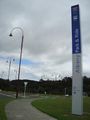
By Google maps it appears to be at the base of a street light in a median strip out in Albany.
Participants
Plans
JimmyNZ,Greenslime: I was all keen to drive out, snap a pic then return home, but with Greenslime prodding me we hatched a very devious plan.
Basically we decided to run to the hash point via one route; stop and take photos; and then walk up to a bus depot; catch a ride back on a different route; and finally run the remainder from where the bus dropped us off to our home.
Krintar:Everyone I talked to about having a geohashing adventure seemed lazy and uninterested, so I was on the brink of deciding to just leave my first hash for some other day... then I noticed the location. 'Munroe Lane?' I thought to myself, 'I could do my first hash in Munroe Lane? Awesome.' So I decided to go ahead anyway.
I'll be there around 4pm; hope to see someone else.
Expedition
JimmyNZ,Greenslime:So after carefully planning our route over a cup of coffee, it was still early and with yesterday being Xmas we were both a little too full of food. After packing supplies, including a couple of Greenslimes' homemade fruit mince pies (yum!!) we took off on our little jog. It kinda sucks that we get out of our house and we're facing a steep hill for the next few kilometers. What a rude wake up.
A little time passes, along with 10.17 km (or 6.3 miles for you imperial folk) and we reach the hashpoint. We catch our breaths, sit down for a little hash pie, snap some photos, pick up some trash (It was an AC/DC cd: who throws that stuff out - black ice is a classic!!) for a further geotrash award then amble up to the bus stop.
After only a 4 minute wait for a bus (believe me in New Zealand that's what we call amazing) we jump on, pay a small fortune and sit back in air conditioned comfort for a little siesta.
Once we're ejected it's only a short 3.3 km run (~2 miles folks) until we reach home.
Job done, and a successful Tron Achievement.
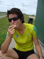
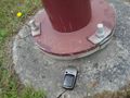
Krintar: Managed to snag a lift out there; parked on Davies Dr. and walked down to the hash point. Not terribly complicated for a first time out, though in retrospect I wish I had thought to set myself up for a few achievements.
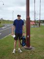
I did manage to convince one of my friends to come out and meet me there, at least. We agreed that it was convenient to have a lamppost marking the hash point. Snapped a few pictures, hey presto, time to go home.
Tracklog
JimmyNZ,Greenslime: http://www.everytrail.com/view_trip.php?trip_id=915946
Photos
Hash from a distance
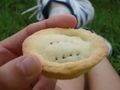
Home-made Xmas mince pies
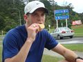
JimmyNZ and Pie
Greenslime and Pie
JimmyNZ with trash
Maybe Krintar will see our tag
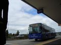
Bus trip home


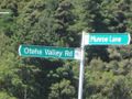
The hash was on Munroe Lane
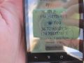
GPS at the hash point
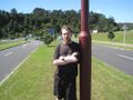
Krintar at the hash
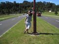
Friend Kerry at the hash


Achievements
JimmyNZ and Greenslime earned the Tron achievement
|
JimmyNZ and Greenslime earned the Pie Geohash Achievement
|
JimmyNZ and Greenslime earned the GeoTrash Geohash Achievement
|
JimmyNZ and Greenslime earned the Walk geohash Achievement
|
JimmyNZ and Greenslime earned the Public transport geohash achievement
|
Krintar earned the Land geohash achievement
|
Krintar earned the Drag-along achievement
|
Challenge

- Meetup on 2010-12-26
- Meetup in -36 174
- Tron achievement
- Pie geohash achievement
- Geotrash achievement
- Walk geohash achievement
- Public transport geohash achievement
- Land geohash achievement
- Drag-along achievement
- A Tale of Two Hashes challenge
- Expeditions
- Expeditions with photos
- Coordinates reached
- Meetup in the Auckland Region