Difference between revisions of "2010-12-31 52 1"
imported>Sourcerer (Created page with "== Location == In a field a few paces off the road up a slippery bank 5 miles west of Ipswich Suffolk, UK. {{meetup graticule | lat=52 | lon=1 | date=2010-12-31 ...") |
imported>FippeBot m (Location) |
||
| (3 intermediate revisions by one other user not shown) | |||
| Line 1: | Line 1: | ||
| − | |||
| − | |||
| − | |||
| − | |||
{{meetup graticule | {{meetup graticule | ||
| lat=52 | | lat=52 | ||
| Line 8: | Line 4: | ||
| date=2010-12-31 | | date=2010-12-31 | ||
| graticule_name=Norwich | | graticule_name=Norwich | ||
| − | | graticule_link=Norwich, United Kingdom}} | + | | graticule_link=Norwich, United Kingdom |
| + | }} | ||
| + | |||
| + | == Location == | ||
| + | |||
| + | In a field a few paces off the road up a slippery bank 5 miles west of Ipswich Suffolk, UK. | ||
== Participants == | == Participants == | ||
| Line 24: | Line 25: | ||
== Photo Gallery == | == Photo Gallery == | ||
| − | <gallery | + | <gallery> |
| − | Image:2010-12-31_52_1_Sourcerer_1.jpg| | + | Image:2010-12-31_52_1_Sourcerer_1.jpg|Google Earth Track Evidence |
</gallery> | </gallery> | ||
| − | == | + | {{Sourcerer_links |
| − | + | | prev = 2010-12-27_52_1 | |
| − | + | | curr = 2010-12-31_52_1 | |
| + | | next = 2011-01-01_52_0 | ||
| + | | date = 2010-12-31 | ||
| + | }} | ||
| + | [[Category:Expeditions]] | ||
[[Category:Expeditions with photos]] | [[Category:Expeditions with photos]] | ||
[[Category:Coordinates reached]] | [[Category:Coordinates reached]] | ||
| − | + | {{location|GB|ENG|SFK}} | |
| − | |||
Latest revision as of 05:06, 9 August 2019
| Fri 31 Dec 2010 in Norwich: 52.0690323, 1.0336712 geohashing.info google osm bing/os kml crox |
Contents
Location
In a field a few paces off the road up a slippery bank 5 miles west of Ipswich Suffolk, UK.
Participants
Expedition
About one hour before midnight and the new year, Neil arrived at the hashpoint. This was technically more difficult than most expeditions. Neil had accidentally deleted all the mapping data from his hand-held satnav. The Europe base-map was still available but this only stored the most major roads. The hashpoint was in deepest rural Suffolk with narrow farm lanes, one of which doubled up as a stream bed. In the dark, judging whether to drive through was interesting. None of these roads were in the satnav database.
It took two attempts to reach the point. The first approach failed because the same fast running stream through dense woodland blocked the route. In summer this might have been easy enough but near midnight in winter, another approach was needed. Eventually Neil located the correct lane, helped by a view of a passing car and the rest of the expedition was easy.
It was nice to be out on such a quiet night. All the sane people were having their new year's party.
Photo Gallery
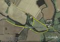
Google Earth Track Evidence

Expeditions and Plans
| 2010-12-31 | ||
|---|---|---|
| Pensacola, Florida | Liberian | A few miles beyond Ragon Hall |
| Portland, Oregon | Jim, APR | In what appears to be an apartment complex out near Troutdale. |
| Regensburg, Germany | dawidi | In a field white void near Schwetzendorf, 10km northwest of Regensburg. |
| Norwich, United Kingdom | Sourcerer | In a field a few paces off the road up a slippery bank 5 miles west of Ipsw... |
Sourcerer's Expedition Links
2010-12-27_52_1 - 2010-12-31_52_1 - 2011-01-01_52_0 - KML file download of Sourcerer's expeditions for use with Google Earth.