Difference between revisions of "2012-08-16 52 1"
imported>Sourcerer (An expedition message sent via Geohash Droid for Android.) |
imported>FippeBot m (Location) |
||
| (4 intermediate revisions by one other user not shown) | |||
| Line 1: | Line 1: | ||
| − | |||
| − | |||
| − | |||
| − | |||
| − | |||
| − | |||
| − | |||
| − | |||
| − | |||
| − | |||
{{meetup graticule | {{meetup graticule | ||
| − | | lat=52 | + | | lat=52 |
| − | | lon=1 | + | | lon=1 |
| − | | date=2012-08-16 | + | | date=2012-08-16 |
| + | | graticule_name=Norwich | ||
| + | | graticule_link=Norwich, United Kingdom | ||
}} | }} | ||
| − | |||
| − | |||
== Location == | == Location == | ||
| − | + | ||
| + | On the west bank of the river Bure, Upton near Acle, Norfolk, UK. | ||
== Participants == | == Participants == | ||
| − | |||
| − | |||
| − | + | [[User:Sourcerer|Sourcerer]] | |
| − | |||
== Expedition == | == Expedition == | ||
| − | |||
| − | + | After collecting A Level exam grades for my 60 students and working out that they were better than last year's, a celebratory expedition was in order. The hashpoint was a few miles west of my college. There was a free car park at the end of the cut at Upton. From there it was a 1260 metre dog leg to the hashpoint. Luckily the Google earth view was a couple of metres out. This put the hashpoint about two paces off the river side footpath. Had the error gone the other way, I'd have been wading in the mud of the reed beds. There were several sailing boats tacking down the river and a few motorised boats passed too. The weather was breezy, hot and humid. | |
| − | |||
== Photos == | == Photos == | ||
| − | < | + | |
| − | Image: | + | <gallery> |
| − | -- | + | Image:2012-08-16 52 1 Sourcerer 1.jpg|Google Earth View |
| − | + | Image:2012-08-16 52 1 Sourcerer 2.jpg|The Moorings at Upton | |
| + | Image:2012-08-16_52_1_12-43-05-524.jpg |The Evidence [http://www.openstreetmap.org/?lat=52.65678405761719&lon=1.5583688020706177&zoom=16&layers=B000FTF @52.6568,1.5584] | ||
| + | Image:2012-08-16 52 1 Sourcerer 4.jpg|A Wayfarer Tacking | ||
| + | Image:2012-08-16 52 1 Sourcerer 5.jpg|The River Bure at the Hashpoint | ||
| + | Image:2012-08-16 52 1 Sourcerer 6.jpg|Reefed Yacht Tacking | ||
</gallery> | </gallery> | ||
| − | + | {{Sourcerer_links | |
| − | {{ | + | | prev = 2012-08-10 56 -3 |
| − | + | | curr = 2012-08-16 52 1 | |
| − | + | | next = 2012-09-02 52 0 | |
| − | + | | date = 2012-08-16 | |
| − | + | }} | |
| − | |||
| − | |||
| − | |||
| − | |||
| − | |||
| − | |||
| − | |||
| − | |||
[[Category:Expeditions]] | [[Category:Expeditions]] | ||
| − | |||
[[Category:Expeditions with photos]] | [[Category:Expeditions with photos]] | ||
| − | |||
| − | |||
| − | |||
| − | |||
| − | |||
[[Category:Coordinates reached]] | [[Category:Coordinates reached]] | ||
| − | + | {{location|GB|ENG|NFK}} | |
| − | |||
| − | |||
| − | |||
| − | |||
| − | |||
| − | |||
| − | |||
| − | |||
| − | |||
| − | |||
| − | |||
| − | |||
| − | |||
| − | |||
| − | |||
| − | |||
| − | |||
Latest revision as of 05:35, 13 August 2019
| Thu 16 Aug 2012 in Norwich: 52.6567681, 1.5583992 geohashing.info google osm bing/os kml crox |
Contents
Location
On the west bank of the river Bure, Upton near Acle, Norfolk, UK.
Participants
Expedition
After collecting A Level exam grades for my 60 students and working out that they were better than last year's, a celebratory expedition was in order. The hashpoint was a few miles west of my college. There was a free car park at the end of the cut at Upton. From there it was a 1260 metre dog leg to the hashpoint. Luckily the Google earth view was a couple of metres out. This put the hashpoint about two paces off the river side footpath. Had the error gone the other way, I'd have been wading in the mud of the reed beds. There were several sailing boats tacking down the river and a few motorised boats passed too. The weather was breezy, hot and humid.
Photos
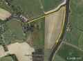
Google Earth View
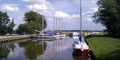
The Moorings at Upton
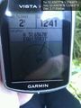
The Evidence @52.6568,1.5584
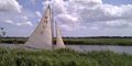
A Wayfarer Tacking
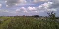
The River Bure at the Hashpoint
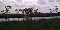
Reefed Yacht Tacking


Expeditions and Plans
| 2012-08-16 | ||
|---|---|---|
| Corpus Christi, Texas | Applesandvodka, His lovely wife. | Western shore of Oso Bay |
| Beersheba, Israel | LinaK | HaHistadrut Street at Askelon, near the entrance to a girl's Ulpena (religi... |
| Newark, New Jersey | Jevanyn | Union County College campus |
| Seattle, Washington | Thomcat, OtherJack, p4r4digm, stand | Seattle, the middle of Latona Avenue NE, just south of 51st NE. |
| Norwich, United Kingdom | Sourcerer | On the west bank of the river Bure, Upton near Acle, Norfolk, UK. |
| Malmö, Sweden | Fasanen, Llavids | Pine woods south of lake Vomb. |
Sourcerer's Expedition Links
2012-08-10 56 -3 - 2012-08-16 52 1 - 2012-09-02 52 0 - KML file download of Sourcerer's expeditions for use with Google Earth.