Difference between revisions of "2015-10-16 52 1"
imported>Sourcerer m (→Photos) |
imported>FippeBot m (Location) |
||
| (5 intermediate revisions by one other user not shown) | |||
| Line 3: | Line 3: | ||
| lon=1 | | lon=1 | ||
| date=2015-10-16 | | date=2015-10-16 | ||
| + | | graticule_name=Norwich, UK | ||
| + | | graticule_link=Norwich, United Kingdom | ||
}} | }} | ||
__NOTOC__ | __NOTOC__ | ||
| Line 8: | Line 10: | ||
== Location == | == Location == | ||
| − | In the middle of Freelands (road), Mendlesham, Suffolk, UK - no need to get out of the car! | + | 6) In the middle of Freelands (road), Mendlesham, Suffolk, UK - no need to get out of the car! |
== Participants == | == Participants == | ||
| Line 23: | Line 25: | ||
*Arrived. -- [[User:Sourcerer|Sourcerer]] ([[User talk:Sourcerer|talk]]) [http://www.openstreetmap.org/?lat=52.24812269&lon=1.08260930&zoom=16&layers=B000FTF @52.2481,1.0826] 01:50, 16 October 2015 (GMT+01:00) | *Arrived. -- [[User:Sourcerer|Sourcerer]] ([[User talk:Sourcerer|talk]]) [http://www.openstreetmap.org/?lat=52.24812269&lon=1.08260930&zoom=16&layers=B000FTF @52.2481,1.0826] 01:50, 16 October 2015 (GMT+01:00) | ||
| + | |||
| + | Navmii running on an Android tablet tried to route me into a "no-entry". Of course this is not Navmii's fault. I fired up OpenStreetMap and corrected the the problem road. After the next update, that will not happen again. | ||
| + | |||
| + | Following an alternative route I reached the cul-de-sac. No speed racer here. With engine and lights off, I got the evidence photos and uploaded my "Arrived" message, only 10 minutes later than planned. | ||
== Photos == | == Photos == | ||
| Line 32: | Line 38: | ||
== Achievements == | == Achievements == | ||
{{#vardefine:ribbonwidth|700px}} | {{#vardefine:ribbonwidth|700px}} | ||
| + | |||
| + | {{OpenStreetMap achievement | ||
| + | | latitude = 52 | ||
| + | | longitude = 1 | ||
| + | | date = 2015-10-16 | ||
| + | | OSMlink = 34667107 | ||
| + | | name = Sourcerer | ||
| + | }} | ||
{{Sourcerer_links | {{Sourcerer_links | ||
| prev = 2015-10-16 52 0 | | prev = 2015-10-16 52 0 | ||
| curr = 2015-10-16 52 1 | | curr = 2015-10-16 52 1 | ||
| − | | next = 2015-10- | + | | next = 2015-10-19 52 1 |
| date = 2015-10-16 | | date = 2015-10-16 | ||
}} | }} | ||
| Line 43: | Line 57: | ||
[[Category:Expeditions with photos]] | [[Category:Expeditions with photos]] | ||
[[Category:Coordinates reached]] | [[Category:Coordinates reached]] | ||
| + | {{location|GB|ENG|SFK}} | ||
Latest revision as of 05:28, 15 August 2019
| Fri 16 Oct 2015 in Norwich, UK: 52.2485925, 1.0818851 geohashing.info google osm bing/os kml crox |
Location
6) In the middle of Freelands (road), Mendlesham, Suffolk, UK - no need to get out of the car!
Participants
Plans
Expedition six of six spanning midnight.
2015-10-15 52 1 - 2015-10-15 52 0 - 2015-10-15 52 -0 - 2015-10-16 52 -0 - 2015-10-16 52 0 - 2015-10-16 52 1 - ETA 01:40.
Expedition
- Arrived. -- Sourcerer (talk) @52.2481,1.0826 01:50, 16 October 2015 (GMT+01:00)
Navmii running on an Android tablet tried to route me into a "no-entry". Of course this is not Navmii's fault. I fired up OpenStreetMap and corrected the the problem road. After the next update, that will not happen again.
Following an alternative route I reached the cul-de-sac. No speed racer here. With engine and lights off, I got the evidence photos and uploaded my "Arrived" message, only 10 minutes later than planned.
Photos
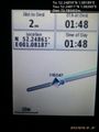
Proof. @52.2481,1.0826
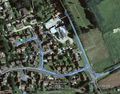
Track in Google Earth


Achievements
Sourcerer earned the OpenStreetMap achievement
|
Expeditions and Plans
| 2015-10-16 | ||
|---|---|---|
| Northampton, United Kingdom | Sourcerer | 4) In a field south west of Elsworth, Cambridgeshire, UK. |
| Cambridge, United Kingdom | Sourcerer, Benjw, Tongs/B | 5) A road hashpoint between Oakington and Girton, Cambridgeshire, UK. |
| Norwich, United Kingdom | Sourcerer | 6) In the middle of Freelands (road), Mendlesham, Suffolk, UK - no need to ... |
Sourcerer's Expedition Links
2015-10-16 52 0 - 2015-10-16 52 1 - 2015-10-19 52 1 - KML file download of Sourcerer's expeditions for use with Google Earth.