Difference between revisions of "2016-05-31 52 -3"
imported>Sourcerer m (→Photos) |
m (Location correction) |
||
| (14 intermediate revisions by 2 users not shown) | |||
| Line 8: | Line 8: | ||
== Location == | == Location == | ||
| − | Rhwng ac i'r gorllewin o Llanwrtyd ac Abergwesyn, Powys, | + | Rhwng ac i'r gorllewin o Llanwrtyd ac Abergwesyn, Powys, Cymru. |
== Participants == | == Participants == | ||
| Line 20: | Line 20: | ||
== Expedition == | == Expedition == | ||
| − | + | '''Here is the short version.''' | |
| − | + | I've washed off the dried blood, emptied my pockets of twigs and pine park fragments and showered the resinous detritus out of my hair. This was a long expedition. Road access to mid Wales is not great and the country is bigger than you might think. Setting out at 10:50 in beautiful sunshine, it took until 15:00 to reach the parking place. The outward walk in hazy sun and a stiff breeze took 1 hour 40 minutes. The return was the same but there was a good pause for sandwiches and a drink. The total distance walked was 9.1 km. The entire track log was 682 km. I got home well after midnight. | |
| + | |||
| + | '''Now for the detail. [http://www.wikiloc.com/wikiloc/view.do?id=13525225 Track Log]''' | ||
| + | |||
| + | After a four hour drive, a 4.5 km walk and a 340 metre climb there was no way this point could not be reached. It was located in a dense commercial pine plantation. | ||
| + | |||
| + | '''The stupidity distance!''' | ||
| + | |||
| + | Baby pines are soft, like fur coats in Narnia. Mature pines stand like pillars in a cathedral and the low branches have all fallen, leaving wide aisles. Of course I got middle age pines with a mesh of intertwined branches. A few were still soft. Some were brittle and snapped easily. The rest would have made good whips for small boys in a Dickensian novel. Masochism is not a normal aspect of my character so this was a new experience. It worked best to squeeze the head forward between the branches and allow the stabbing snaps and whiplash spring-backs to damage the rest of the body. To add interest the ground underfoot was soft and spongy, consisting mainly of very deep sphagnum moss. Luckily it was dry apart from occasional trick pools. So slightly bloodied, after 250 metres of pain, I reached the hashpoint, got a photo and failed to get 3G access. Later I discovered it was turned off in the phone. The return was slightly easier following the trail of snapped twigs and mossy footprints. | ||
| + | |||
| + | This was interesting terrain. There were peat crevasses of unknown depth. Small streams had made gorges in the peat. These were narrow, unstable and had near vertical sides. Some were covered with branches and leaves making traps for animals or geohashers. To be swallowed by a peat crevasse followed by a wet land collapse would be an interesting way to meet ones doom. You'd be found three thousand years later, well preserved, with a [[User:Crox/Poster|Crox poster]]! [https://en.wikipedia.org/wiki/Lindow_Man Lindow Man] aka Pete Marsh. | ||
== Photos == | == Photos == | ||
| Line 31: | Line 41: | ||
Image:2016-05-31 52 -3 Sourcerer Track Stupidity.jpg | Stupidity Distance | Image:2016-05-31 52 -3 Sourcerer Track Stupidity.jpg | Stupidity Distance | ||
Image:2016-05-31 52 -3 Sourcerer Profile.jpg | Altitude | Image:2016-05-31 52 -3 Sourcerer Profile.jpg | Altitude | ||
| − | Image:2016-05-31 52 -3 Sourcerer 03.jpg | Irfon | + | Image:2016-05-31 52 -3 Sourcerer 03.jpg | Afon Irfon at Pwll Bo |
Image:2016-05-31 52 -3 Sourcerer 04.jpg | Tiny waterfall | Image:2016-05-31 52 -3 Sourcerer 04.jpg | Tiny waterfall | ||
Image:2016-05-31 52 -3 Sourcerer 05.jpg | Bilingual sign | Image:2016-05-31 52 -3 Sourcerer 05.jpg | Bilingual sign | ||
| Line 46: | Line 56: | ||
Image:2016-05-31 52 -3 Sourcerer 25.jpg | Selfie | Image:2016-05-31 52 -3 Sourcerer 25.jpg | Selfie | ||
Image:2016-05-31 52 -3 Sourcerer 13.jpg | Forestry track | Image:2016-05-31 52 -3 Sourcerer 13.jpg | Forestry track | ||
| − | Image:2016-05-31 52 -3 Sourcerer 14.jpg | Irfon | + | Image:2016-05-31 52 -3 Sourcerer 14.jpg | Afon Irfon at Pwll Bo |
| − | Image:2016-05-31 52 -3 Sourcerer 15.jpg | Irfon | + | Image:2016-05-31 52 -3 Sourcerer 15.jpg | Afon Irfon at Pwll Bo |
| − | Image:2016-05-31 52 -3 Sourcerer 16.jpg | Irfon | + | Image:2016-05-31 52 -3 Sourcerer 16.jpg | Afon Irfon at Pwll Bo |
| − | Image:2016-05-31 52 -3 Sourcerer 17.jpg | Irfon | + | Image:2016-05-31 52 -3 Sourcerer 17.jpg | Afon Irfon at Pwll Bo |
| − | Image:2016-05-31 52 -3 Sourcerer 18.jpg | | + | Image:2016-05-31 52 -3 Sourcerer 18.jpg | Boggy pool car park |
Image:2016-05-31 52 -3 Sourcerer 19.jpg | Welsh language | Image:2016-05-31 52 -3 Sourcerer 19.jpg | Welsh language | ||
Image:2016-05-31 52 -3 Sourcerer 20.jpg | Welsh dragon | Image:2016-05-31 52 -3 Sourcerer 20.jpg | Welsh dragon | ||
| − | Image:2016-05-31 52 -3 Sourcerer 21.jpg | Irfon | + | Image:2016-05-31 52 -3 Sourcerer 21.jpg | Afon Irfon at Pwll Bo |
| − | Image:2016-05-31 52 -3 Sourcerer 22.jpg | Irfon | + | Image:2016-05-31 52 -3 Sourcerer 22.jpg | Afon Irfon at Pwll Bo |
Image:2016-05-31 52 -3 Sourcerer 23.jpg | Forestry Commission Wales | Image:2016-05-31 52 -3 Sourcerer 23.jpg | Forestry Commission Wales | ||
</gallery> | </gallery> | ||
| Line 60: | Line 70: | ||
== Achievements == | == Achievements == | ||
{{#vardefine:ribbonwidth|800px}} | {{#vardefine:ribbonwidth|800px}} | ||
| + | |||
| + | {{Border geohash achievement | ||
| + | | latitude = 52 | ||
| + | | longitude = -3 | ||
| + | | date = 2016-05-31 | ||
| + | | country1 = Wales | ||
| + | | country2 = England | ||
| + | | name = Sourcerer | ||
| + | | image = 2016-05-31_52_-3_Sourcerer_20.jpg | ||
| + | }} | ||
| + | {{Velociraptor geohash | ||
| + | | latitude = 52 | ||
| + | | longitude = -3 | ||
| + | | date = 2016-05-31 | ||
| + | | name = Sourcerer | ||
| + | | image = 2016-05-31 52 -3 Sourcerer 27.jpg | ||
| + | }} | ||
| + | {{xkcd-100-Honorable-Mention | ||
| + | | latitude = 52 | ||
| + | | longitude = -3 | ||
| + | | date = 2016-05-31 | ||
| + | | name = Sourcerer | ||
| + | | distance = 682 km | ||
| + | }} | ||
| + | {{Minesweeper geohash | ||
| + | | graticule = Mid_Wales, United Kingdom | ||
| + | | ranknumber = 3 | ||
| + | | ne = true | ||
| + | | e = true | ||
| + | | se = true | ||
| + | | name = Sourcerer | ||
| + | }} | ||
| + | {{Minesweeper geohash | ||
| + | | graticule = Manchester, United Kingdom | ||
| + | | ranknumber = 4 | ||
| + | | e = true | ||
| + | | se = true | ||
| + | | s = true | ||
| + | | sw = true | ||
| + | | name = Sourcerer | ||
| + | }} | ||
| + | {{Minesweeper geohash | ||
| + | | graticule = Shrewsbury, United Kingdom | ||
| + | | ranknumber = 6 | ||
| + | | n = true | ||
| + | | ne = true | ||
| + | | e = true | ||
| + | | se = true | ||
| + | | s = true | ||
| + | | w = true | ||
| + | | name = Sourcerer | ||
| + | }} | ||
| + | {{Minesweeper geohash | ||
| + | | graticule = Bristol, United Kingdom | ||
| + | | ranknumber = 6 | ||
| + | | n = true | ||
| + | | ne = true | ||
| + | | e = true | ||
| + | | se = true | ||
| + | | s = true | ||
| + | | nw = true | ||
| + | | name = Sourcerer | ||
| + | }} | ||
| + | {{OpenStreetMap achievement | ||
| + | | latitude = 52 | ||
| + | | longitude = -3 | ||
| + | | date = 2016-05-31 | ||
| + | | OSMlink = 39700989 | ||
| + | | name = Sourcerer | ||
| + | }} | ||
{{Sourcerer_links | {{Sourcerer_links | ||
| Line 71: | Line 151: | ||
[[Category:Expeditions with photos]] | [[Category:Expeditions with photos]] | ||
[[Category:Coordinates reached]] | [[Category:Coordinates reached]] | ||
| + | [[Category:Insane]] | ||
| + | {{location|GB|CYM|POW}} | ||
Latest revision as of 20:23, 22 May 2020
| Tue 31 May 2016 in 52,-3: 52.1324343, -3.6929796 geohashing.info google osm bing/os kml crox |
Location
Rhwng ac i'r gorllewin o Llanwrtyd ac Abergwesyn, Powys, Cymru.
Participants
Plans
Set out as early as possible from friends in Colwyn Bay and head for mid Wales.
Expedition
Here is the short version.
I've washed off the dried blood, emptied my pockets of twigs and pine park fragments and showered the resinous detritus out of my hair. This was a long expedition. Road access to mid Wales is not great and the country is bigger than you might think. Setting out at 10:50 in beautiful sunshine, it took until 15:00 to reach the parking place. The outward walk in hazy sun and a stiff breeze took 1 hour 40 minutes. The return was the same but there was a good pause for sandwiches and a drink. The total distance walked was 9.1 km. The entire track log was 682 km. I got home well after midnight.
Now for the detail. Track Log
After a four hour drive, a 4.5 km walk and a 340 metre climb there was no way this point could not be reached. It was located in a dense commercial pine plantation.
The stupidity distance!
Baby pines are soft, like fur coats in Narnia. Mature pines stand like pillars in a cathedral and the low branches have all fallen, leaving wide aisles. Of course I got middle age pines with a mesh of intertwined branches. A few were still soft. Some were brittle and snapped easily. The rest would have made good whips for small boys in a Dickensian novel. Masochism is not a normal aspect of my character so this was a new experience. It worked best to squeeze the head forward between the branches and allow the stabbing snaps and whiplash spring-backs to damage the rest of the body. To add interest the ground underfoot was soft and spongy, consisting mainly of very deep sphagnum moss. Luckily it was dry apart from occasional trick pools. So slightly bloodied, after 250 metres of pain, I reached the hashpoint, got a photo and failed to get 3G access. Later I discovered it was turned off in the phone. The return was slightly easier following the trail of snapped twigs and mossy footprints.
This was interesting terrain. There were peat crevasses of unknown depth. Small streams had made gorges in the peat. These were narrow, unstable and had near vertical sides. Some were covered with branches and leaves making traps for animals or geohashers. To be swallowed by a peat crevasse followed by a wet land collapse would be an interesting way to meet ones doom. You'd be found three thousand years later, well preserved, with a Crox poster! Lindow Man aka Pete Marsh.
Photos
Arrived. @52.1342,-3.6846
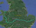
Entire Journey
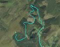
Near the Hashpoint
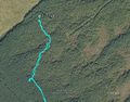
Stupidity Distance
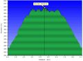
Altitude
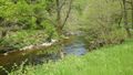
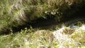
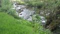
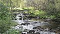
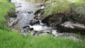
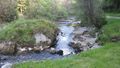
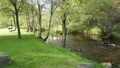
Afon Irfon at Pwll Bo
Tiny waterfall
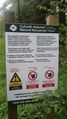
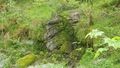
Bilingual sign
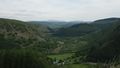
View of Mid Wales
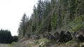
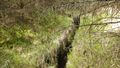
Forestry track
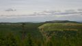
View of Mid Wales
Storm damage
Peat crevasse
Peat crevasse
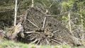
Storm damage
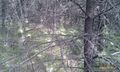
Stupidity terrain
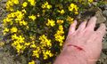
Blood and flowers

Blood
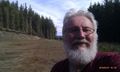
Selfie
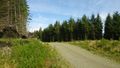
Forestry track
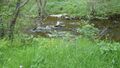
Afon Irfon at Pwll Bo
Afon Irfon at Pwll Bo
Afon Irfon at Pwll Bo
Afon Irfon at Pwll Bo
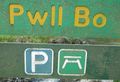
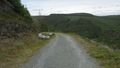
Boggy pool car park
Welsh language
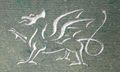
Welsh dragon
Afon Irfon at Pwll Bo
Afon Irfon at Pwll Bo
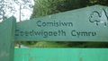
Forestry Commission Wales


Achievements
Sourcerer earned the Border geohash achievement
|
Sourcerer earned the Velociraptor Geohash Achievement
|
Sourcerer earned the XKCD-100 Honorable Mention Achievement
|
Sourcerer achieved level 3 of the Minesweeper Geohash achievement
|
Sourcerer achieved level 4 of the Minesweeper Geohash achievement
|
Sourcerer achieved level 6 of the Minesweeper Geohash achievement
|
Sourcerer achieved level 6 of the Minesweeper Geohash achievement
|
Sourcerer earned the OpenStreetMap achievement
|
Expeditions and Plans
| 2016-05-31 | ||
|---|---|---|
| Los Angeles, California | McKay | Just off the road, just off the beach in Malibu. |
| Mid Wales, United Kingdom | Sourcerer | Rhwng ac i'r gorllewin o Llanwrtyd ac Abergwesyn, Powys, Cymru. |
Sourcerer's Expedition Links
2016-05-23 52 1 - 2016-05-31 52 -3 - 2016-06-01 52 1 - KML file download of Sourcerer's expeditions for use with Google Earth.