Difference between revisions of "2018-05-21 52 -0"
From Geohashing
imported>Sourcerer m ([live picture] Woodland hashpoint. [http://www.openstreetmap.org/?lat=52.74992645&lon=-.37666798&zoom=16&layers=B000FTF @52.7499,-.3767]) |
imported>Sourcerer m (→New expedition) |
||
| Line 1: | Line 1: | ||
| − | + | {{meetup graticule | |
| − | |||
| − | |||
| − | |||
| − | |||
| − | |||
| − | |||
| − | |||
| − | |||
| − | |||
| − | {{meetup graticule | ||
| lat=52 | | lat=52 | ||
| lon=-0 | | lon=-0 | ||
| date=2018-05-21 | | date=2018-05-21 | ||
| + | | graticule_name=Northampton, UK | ||
| + | | graticule_link=Northampton, United Kingdom | ||
}} | }} | ||
| − | |||
| − | |||
__NOTOC__ | __NOTOC__ | ||
| + | == Location == | ||
| − | + | Woodland south of Bourne, Kincolnshire, UK. | |
| − | |||
== Participants == | == Participants == | ||
| − | + | ||
| − | + | [[User:Sourcerer|Sourcerer]] | |
== Plans == | == Plans == | ||
| − | + | ||
| + | One of Three - [[2018-05-21_52_-0]] - [[2018-05-21_52_0]] - [[2018-05-21_52_1]] | ||
== Expedition == | == Expedition == | ||
| − | |||
| − | + | This was easy. There was parking in a new housing estate of minimal architectural merit. Over the main road, south, a well-used public footpath led to the woods. There were multiple paths in the woodland and by design, with a bit of luck, the first path I tried led right to the hashpoint. Only a dozen easy paces were needed off the path. | |
| − | |||
| − | |||
| − | |||
| − | |||
| − | |||
| − | |||
| + | == Photos == | ||
| + | <gallery caption="Gallery" widths="200px" heights="200px" perrow="3"> | ||
Image:2018-05-21_52_-0_Sourcerer_1526903318273.jpg | Arrived. [http://www.openstreetmap.org/?lat=52.74992645&lon=-.37664652&zoom=16&layers=B000FTF @52.7499,-.3766] | Image:2018-05-21_52_-0_Sourcerer_1526903318273.jpg | Arrived. [http://www.openstreetmap.org/?lat=52.74992645&lon=-.37664652&zoom=16&layers=B000FTF @52.7499,-.3766] | ||
| − | |||
Image:2018-05-21_52_-0_Sourcerer_1526903534369.jpg | Woodland hashpoint. [http://www.openstreetmap.org/?lat=52.74992645&lon=-.37666798&zoom=16&layers=B000FTF @52.7499,-.3767] | Image:2018-05-21_52_-0_Sourcerer_1526903534369.jpg | Woodland hashpoint. [http://www.openstreetmap.org/?lat=52.74992645&lon=-.37666798&zoom=16&layers=B000FTF @52.7499,-.3767] | ||
| + | Image:2018-05-21 52 -0 Sourcerer.jpg | GOogle Earth Track | ||
</gallery> | </gallery> | ||
== Achievements == | == Achievements == | ||
{{#vardefine:ribbonwidth|800px}} | {{#vardefine:ribbonwidth|800px}} | ||
| − | |||
| − | + | {{Geohashing Day | |
| − | + | | latitude = 52 | |
| − | + | | longitude = -0 | |
| + | | year = 2018 | ||
| + | | coorddate= 2018-05-21 | ||
| + | | name = Sourcerer | ||
| + | }} | ||
| − | + | {{Sourcerer_links | |
| + | | prev = 2018-05-16_52_1 | ||
| + | | curr = 2018-05-21_52_-0 | ||
| + | | next = 2018-05-21_52_0 | ||
| + | | date = 2018-05-21 | ||
| + | }} | ||
| − | |||
| − | |||
| − | |||
| − | |||
| − | |||
| − | |||
| − | |||
| − | |||
[[Category:Expeditions]] | [[Category:Expeditions]] | ||
| − | |||
[[Category:Expeditions with photos]] | [[Category:Expeditions with photos]] | ||
| − | |||
| − | |||
| − | |||
| − | |||
| − | |||
[[Category:Coordinates reached]] | [[Category:Coordinates reached]] | ||
| − | |||
| − | |||
| − | |||
| − | |||
| − | |||
| − | |||
| − | |||
| − | |||
| − | |||
| − | |||
| − | |||
| − | |||
| − | |||
| − | |||
| − | |||
| − | |||
| − | |||
| − | |||
Revision as of 16:46, 21 May 2018
| Mon 21 May 2018 in Northampton, UK: 52.7499123, -0.3766712 geohashing.info google osm bing/os kml crox |
Location
Woodland south of Bourne, Kincolnshire, UK.
Participants
Plans
One of Three - 2018-05-21_52_-0 - 2018-05-21_52_0 - 2018-05-21_52_1
Expedition
This was easy. There was parking in a new housing estate of minimal architectural merit. Over the main road, south, a well-used public footpath led to the woods. There were multiple paths in the woodland and by design, with a bit of luck, the first path I tried led right to the hashpoint. Only a dozen easy paces were needed off the path.
Photos
- Gallery
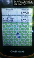
Arrived. @52.7499,-.3766
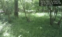
Woodland hashpoint. @52.7499,-.3767
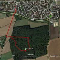
GOogle Earth Track


Achievements
Sourcerer earned the 2018 Geohashing Day achievement
|
Expeditions and Plans
| 2018-05-21 | ||
|---|---|---|
| Sorocaba, Brazil | Copper | Inside private property within few blocks of Copper's childhood neighborhoo... |
| Pforzheim, Germany | DLichti, a friend | In the forest near Lautenbach. |
| Erfurt, Germany | Reinhard | In a forest between the villages Oberhasel, Teichweiden and Mötzelbach near... |
| Köln, Germany | FelixTheCat | In the forest near Großhau, kreis Düren, Germany. |
| Bonn, Germany | pah | In a forest close to Stadt Blankenberg (Hennef, Germany). |
| Eindhoven, Netherlands | Trevil | In a field east of Gewande, a small town NE of 's Hertogenbosch. |
| Kassel, Germany | GeorgDerReisende | The hash lay between a lake and a lane at Höxter-Godelheim. |
| Northampton, United Kingdom | Sourcerer | Woodland south of Bourne, Lincolnshire, UK. |
| Cambridge, United Kingdom | Sourcerer, Benjw, Tongs/B | West of the Great Ouse, West Lynn, Norfolk, UK. |
| Norwich, United Kingdom | Sourcerer | A field perimeter track east of the disused airfield at Coltishall, Norfolk... |
| Oslo, Norway | Someone went | Somewhere |
| Helsinki, Finland | Someone went | Not published yet |
| Vantaa, Finland | Someone went | Not published yet |
Sourcerer's Expedition Links
2018-05-16_52_1 - 2018-05-21_52_-0 - 2018-05-21_52_0 - KML file download of Sourcerer's expeditions for use with Google Earth.