Difference between revisions of "2022-01-30 40 -4"
m (→Expedition) |
m (→Expedition) |
||
| (6 intermediate revisions by 3 users not shown) | |||
| Line 54: | Line 54: | ||
I had the GoPro since quite some time, but curiously I had | I had the GoPro since quite some time, but curiously I had | ||
never used it to film from the motorcycle (I did that in the | never used it to film from the motorcycle (I did that in the | ||
| − | old days by putting a Super | + | old days by putting a Super 8 ''film'' camera in the hands |
of the passenger). | of the passenger). | ||
In the end it turned out that the navigation device | In the end it turned out that the navigation device | ||
| Line 76: | Line 76: | ||
At the end of the straight, I have to reduce the speed | At the end of the straight, I have to reduce the speed | ||
| − | to turn | + | to turn into the road to the geohash. The minimum speed |
is 13.3 km/h at 696 seconds. In the video, the minimum | is 13.3 km/h at 696 seconds. In the video, the minimum | ||
| − | speed while turning occurs at 2:02. Because we know | + | speed while turning occurs at 2:02, as can be seen on the Goldwing's speedo. Because we know |
that the closest approach occurred at 732 seconds in the | that the closest approach occurred at 732 seconds in the | ||
track data, we can conclude that the ride through happens | track data, we can conclude that the ride through happens | ||
| − | at 2:38 in the | + | at 2:38 in the video. |
The last few hundred meters before the geohash turned | The last few hundred meters before the geohash turned | ||
| Line 119: | Line 119: | ||
<youtube>https://www.youtube.com/watch?v=TTSkqpEnsmc</youtube> | <youtube>https://www.youtube.com/watch?v=TTSkqpEnsmc</youtube> | ||
| − | The geohash is ridden through at 2:38. The total length of the video is 8:37, with cornering through tight serpentines 5:00-7:00, followed by a ride through | + | The geohash is ridden through at 2:38. The total length of the video is 8:37, with cornering through tight serpentines 5:00-7:00, followed by a ride through the village of ''Navas de Riofrío.'' |
== Achievements == | == Achievements == | ||
| Line 137: | Line 137: | ||
<!-- An actual expedition: --> | <!-- An actual expedition: --> | ||
[[Category:Expeditions]] | [[Category:Expeditions]] | ||
| − | |||
| − | |||
| − | |||
| − | |||
| − | |||
| − | |||
| − | |||
| − | |||
[[Category:Expeditions with photos]] | [[Category:Expeditions with photos]] | ||
| Line 155: | Line 147: | ||
[[Category:Easy geohash]] | [[Category:Easy geohash]] | ||
| + | {{location|ES|CL|SG}} | ||
Latest revision as of 07:00, 1 February 2022
| Sun 30 Jan 2022 in 40,-4: 40.8994948, -4.1339561 geohashing.info google osm bing/os kml crox |
Location
Directly on the southbound lane of the SG-V-7212 near Segovia.
Participants
Plans
Expedition
This day, I had only the afternoon available, and because it would be a relatively long trip — an almost one and a half hours motorcycle ride one way —, I did not just start on a mystery tour, like in the previous two expeditions 2022-01-10_40_-4 and 2022-01-16_40_-4, but I checked out the geohash on the Maps beforehand. And guess what, it was directly on the road, calling for a second Speed racer achievement after my first one in expedition 2021-11-20_40_-3.
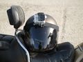
This time, we would not be two in a car, so that one has free hands to take proof, but I would be alone on the Goldwing. So, I set up two independent ways to record the ride. The first one was simply to download the GPS Logger app and have it running on my mobile. The second one was to mount my GoPro on the helmet and film the ride, including the reading of the navigation device mounted on the handle bar. I had the GoPro since quite some time, but curiously I had never used it to film from the motorcycle (I did that in the old days by putting a Super 8 film camera in the hands of the passenger). In the end it turned out that the navigation device was not really readable in the video, so I was glad to have the data from the GPS logger.
In my plot, the track starts at the left edge. There is a long straight that first approaches the geohash and then moves away again before the track turns around to go through the geohash. This is also reflected in the plot of distance vs. time. The track reaches its closest point at 732 seconds with 2.79 meters distance, sufficiently close, I would say.
The plot of Speed vs. time shows the departure from the parking space at 637 seconds. I accelerate to 95 km/h on the Goldwing built in speedo, which corresponds to 90 km/h (the maximum allowed speed) on the navigation device. Then I activate the cruise control, and the speed gets quite stable. The idea was to use this setting also for driving through the geohash.
At the end of the straight, I have to reduce the speed to turn into the road to the geohash. The minimum speed is 13.3 km/h at 696 seconds. In the video, the minimum speed while turning occurs at 2:02, as can be seen on the Goldwing's speedo. Because we know that the closest approach occurred at 732 seconds in the track data, we can conclude that the ride through happens at 2:38 in the video.
The last few hundred meters before the geohash turned out to be quite curvy, so there was no time to activate the cruise control. I had to accelerate manually and just managed to reach the required speed at the geohash. This is nicely demonstrated by the plot of Speed vs. distance. At the left edge, the distance goes down to 2.79 meters and the velocity at that point is 85.7 km/h. I consider this to be in the admissible range for the Speed racer achievement.
Tracklog
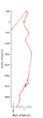
My plot with x and y distances from the geohash, which is the green spot at the origin.
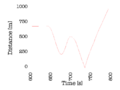
Distance from the geohash vs. time.
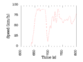
Speed vs. time.
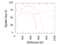
Speed vs. distance from the geohash.


Photos
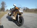
Getting ready for the Speed racer achievement. Still 2 km to go to the geohash.
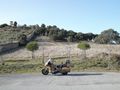
The parking space is next to the Palacio y bosque de Riofrío (to the left of the wall).
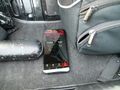
Starting the GPS Logger.
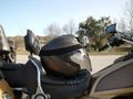
Mounting the GoPro on the Helmet.
It's a Hero 3, so you can tell I have it for quite some time.


Videos
The geohash is ridden through at 2:38. The total length of the video is 8:37, with cornering through tight serpentines 5:00-7:00, followed by a ride through the village of Navas de Riofrío.
Achievements
