2009-05-21 48 -123
It's Geohashing Day and time to mount an extra-special extravaganza of an expedition.
| Thu 21 May 2009 in Victoria: 48.8587364, -123.5438145 geohashing.info google osm bing/os kml crox |
Contents
Location
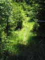
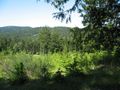
In a clearing on Salt Spring Island, a mere 200m from a nice paved road, fairly close to an abandoned building foundation. Only lightly protected by bushes, brambles, barbed wire and a solid-looking gate. Not a single "No trespassing" sign in sight.
Planning
After a week of anticipation and almost an hour of discussion in IRC chat, the final schedule for Vancouver's Geohashing Day celebration was set at 07:25.
Coordinates in the Vancouver 49,-123 graticule were in the northern mountains and beyond our group's current capability for a one-day trip, but there was an accessible-seeming point one graticule south in Victoria. Unfortunately, the ferry we had to take to get to that point at a reasonable time was on the other side of a tunnel, and too far away for everyone to reach in time by bicycle. So the Vancouver graticule decided to do something strange and unusual for Geohashing Day. We would travel a distance of less than 100 km, by car.
Salt Spring Island has three ferry terminals (Long Harbour, Fulford Harbour and Vesuvius Bay), for ferries all going to different places, two of which were useful for getting back to Vancouver. In order to have a back up plan we couldn't leave the car at Tsawwassen, or it would be stranded there. So Rhonda would drive.
The schedule
- Rhonda will pick up known participants. Surprise guests are welcome to meet us at the ferry.
- 10:10 Ferry from Tsawwassen to Long Harbour, Salt Spring [1]
- 13:10 Ferry arrives in Long Harbour
- 13:30 arrive at hashpoint
- Zany festivities? Cake? Board games?
- 14:45 pack up
- 15:25 Ferry from Long Harbour to Tsawwassen departs [2]
Backup plan
- 17:50 Ferry from Fulford Harbour to Swartz Bay [3]
- 19:00 Ferry from Swartz Bay to Tsawwassen
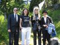
Participants
- Rhonda driving the vehicle
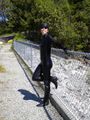
- Robyn in a catwoman costume.
- Elbie in formal attire
- Xore in an XKCD t-shirt
- Wade in formal attire
Getting the Expedition Together
Rhonda
I woke up with my alarm at 6AM, determined to get breakfast well underway before the co-ordinates were released at 6:30, despite having been up late the night before putting the chocolate decorations on the geohashiversary cake. After determining that the Vancouver graticule co-ordinates were as absurdly out of reach for a one-day trip as usual, we started comparing other graticules co-ordinates with our retrohash backup plan. Saltspring vs. Gabriola was what it came down to.
Since the ferry schedules were not all that useful for day trips, especially on bicycles, a plan emerged after some discussion that involved me, who lived the farthest from the ferry terminal, picking everybody else up on my way there. This involved driving the entire length of Vancouver, during rush hour.
Undaunted, I plotted a course with Google maps for no-traffic estimates of travel times, then announced my estimated pick up times to the others and let them know what side of the street corner they should be standing on so I didn't block rush-hour traffic for too long while they got in the car. I had to leave in under a half hour, so I signed off IRC to pack what few things I needed for a carhash - mostly the cake, a game, some party balloons, and water. I was out the door five minutes before I had planned, and crossed my fingers that there wouldn't be a stall or accident on the bridge.
There wasn't; the 4-lane merge was operating smoothly and once past that traffic was flowing slightly above the speed limit. The first two pick-up points also happened to take advantage of the two rush-hour avoidance routes I know, and I got to the downtown one right on time to pick up Xore.
Xore
Xore groaned and smacked the alarm clock before rolling out of bed at 6am. He wandered into the kitchen to get breakfast going before joining IRC, blithely letting everyone else do all the brainwork and planning as he munched on noms. His only job was to get paper plates, forks and napkins from the store so that cake could be consumed without resorting to finger face stuffing. But what was this? He had barely a half hour after the final decision was made to accomplish this and meet up with Rhonda.
He dashed down the elevator, down the block to the mart where he found paper plates, forks, and napkins, quite likely in that exact order. Garbage bags were also considered, but then Xore remembered he had some at home. But what was this? There was only one cashier at the checkout, and Xore spent twenty agonizing minutes waiting as the man in front of him brought in a pack of cigarettes and required an exchange for a specific brand. There were computer problems, A manager was called in, and complex processes had to be observed. Oh, the humanity! A queue formed filled with irate shoppers who wanted to leave, but Xore kept his cool, as far as the parking lot. He had distance to travel and little time to travel it in.
Xore dashed home from the mart, ran back up the elevator, and grabbed the garbage bags. He considered very briefly switching to formal wear and discarded the notion as there was no more time left. No more time. T minus 0. Liftoff. And he hadn't left the building yet. He dashed out the door, to the sound of Rhonda ringing his cell.
"Hello?"
Thud. Thud. The deadbolts sunk home like a drunken pile driver on the morning after.
Rhonda had just arrived.
"I'll be there in 2 or 3 minutes." Xore ran down the elevator again, down the block, maintaining his debonaire exterior as he arrived at the curb where Rhonda was parked. They were off!
The day was bright and sunny, with barely a cloud in the sky as they cruised along the back roads to UBC. Rhonda knew them like a pro, avoiding all traffic and making excellent time to pick up Elbie.
Elbie
Elbie was woken up at 6:20 by her alarm, and promptly rolled out of bed and into her desk chair. Quickly booting up her laptop, she navigated over to the geohashing map and started impatiently going Ctrl-R every minute until the coordinates were released. After partaking in the planning process in IRC and making breakfast, she was soon out the door, waiting for Rhonda to pick her up on Marine Drive.
After confirming that the stranger driving the station wagon who had stopped next to her was in fact Rhonda, she hopped in and introduced herself, then the three sped off across town again to find Robyn and Wade, who were waiting at a gas station on a road convenient to both their home and the route to the ferries.
Robyn & Wade
Robyn was up, bright-eyed and bushy-tailed when the alarm went off at 6:17, She was online chatting and planning as soon as the coordinates were revealed.
Wade was up, dim-eyed and droopy-tailed around 7:00. He made breakfast for Robyn and himself, then checked the hash location. He accidentally clicked on the Port Alberni graticule when aiming for Vancouver, and saw the meetup point was a nice and accessible point in the middle of a street in Powell River. Powell River is two ferry rides up the Sunshine coast from Vancouver, which can be a challenge, but he could hear Robyn muttering about ferry schedules, so he felt everything was under control. He wandered back to shower and shave. Eventually Robyn said that the ferry schedule would not work with bicycles, so there would be a car in use. Wade then decided to dress for a formal geohash, since the Powell River location was so easy to access.
Meanwhile, Robyn continued to plan online with Rhonda, Xore and Elbie, taking a break only to create a new "XKCD" geohashing flag. The plan was finalized. She told Wade we were to be picked up at the nearby gas station at (or shortly after) exactly 8:45, and she matched Wade's formal suit with her Catwoman costume. The walk to the gas station was uneventful, although a lot of people stared at the "Man in black / Cat woman" couple. Wade was waiting for an accident, but fortunately none occurred (although it would have been amusing, it probably would have thrown us off our schedule). After only a few minutes waiting at the gas station, Rhonda's heroic Volvo arrived, complete with Rhonda, Xore and Elbie.
The Group Expedition
A Three Hour Trip
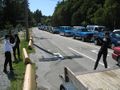
With everyone in the vehicle, we continued to the ferry terminal. Traffic started out bad on Knight Street (which is pretty good, since at this time of day one would expect it to be terrible), and only got better as we approached the ferry terminal. Monday was a holiday so perhaps many workers may have taken the whole week off, and most people have got to work by nine am, anyway. We rolled through the ferry tollbooth (stopping to pay an exorbitant amount to get all of us on the boat) and were in the waiting lane with almost an hour remaining before sailing.
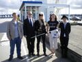
We took a round of "before" photographs, and then Wade and Elbie went in search of caffeinated beverages, while the rest stood around enjoying the sunshine and marvelling at the acoustical engineering that produced the periodic and wholly unintelligible announcements over the public address system. Rhonda claims she heard the words 'Salt Spring' in one, but it may have been a retroactive interpretation due to the fact that shortly afterwards vehicles ahead of us started to move. Wade and Elbie were nowhere to be seen, and certainly couldn't be expected to respond to the 'announcement'. Rhonda pulled to the side and allowed other vehicles to pass us, while Xore went in search of the missing geohashers. They reappeared, sauntering across the parking lot, but, thanks to the caffeine injections, hurried when the situation became clear.
Wade failed to notice that none of the garbled announcements sounded like "Powell River" or "Sunshine Coast". This is not surprising, since none of the garbled announcements even sounded like English. He also failed to notice that the Sunshine Coast ferries leave from Horseshoe Bay, and we were at Tsawwassen.
We were the second-to-last car loaded on the top deck for Salt Spring. The lower decks were reserved for passengers to other islands. Ours was to be the last stop. This was not to be a short ferry ride, but this is Geohashing Day. Sacrifices must be made. Once were were comfortably on the ferry to Salt Spring Island, and it was clear that this was going to be the only ferry trip to our destination, Wade realized that Powell River was not going to be on the agenda for today. He thought, "I wonder how accessible this meet-up will be? At least I'm not the only one in formal attire, so if it involves brambles and thorns, there will be two of us with ruined suits."
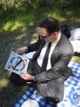
On the passenger deck we staked out a section with our xkcd flag and the fearsome T-Rex and then got down to the real business of geohashing. Games. Given a choice among Citadels, Chrononauts, something else this chronicler doesn't remember, and Killer Bunnies and the Quest for the Magic Carrot, we chose the one with the silliest name. At first it seemed quite daunting with as many as a dozen different kinds of cards, a whole bag of 12-sided dice, and card plays that had to be plotted two moves ahead, but when we figured out that the goal was really more about wreaking random mayhem with everything from maggots to cosmic cheeseballs and sharks with FLBs, we didn't worry too seriously about our bunnies. The game, including a short break for lunch, lasted the entire trip. Wade almost won the game with his pirate carrot, but at the last moment we realized that his only surviving bunny was a holographic projection and thus not actually alive, so the win passed to Xore. He had a lot of carrots, and despite an Ebola epidemic and some very heavily armed adversaries, had a living bunny able to receive the prize.
We returned to the vehicle deck to embark on the next stage of the expedition.
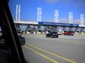
Ferry lines to the Gulf Islands
Waiting for the ferry at Tsawwassen
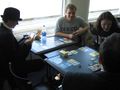
Playing Killer Bunnies and the Quest for the Magic Carrot

Inside view of the ferry bow doors, approaching the dock at Long Harbour


To the Geohash
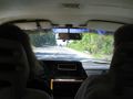
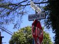
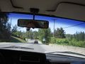
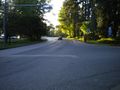
Despite the spontaneous nature of the expedition, we had among us two maps and two sets of driving directions, all of which were in sufficient agreement that we seemed destined to reach the geohash. First we had to join the exodus of ferry traffic and snake along the single road leading through Ganges, the main town on the island. Then we could continue along the roads on the map. Our first wrong turn occurred only 1.3 km from the geohash, when what was "Canal Road" in the directions was "Booth Canal Road" in real life. Looking for a "C" street, we saw a "B" street and didn't make the connection until we were past the fork. We soon found a convenient spot to turn around, right between the Fire Hall and a phonebooth. A phonebooth. Everyone out of the car. We're going to win a ribbon.
At first there was skepticism from some members of the party that all five of us would fit in the one telephone booth, but we put the guys in first -- they were bigger -- and then there was easily room for three girls and a dinosaur to squeeze in around them. The hardest part was taking photographs of everyone at once that still made it clear we were in a phone booth. Achievement: check.
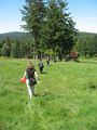
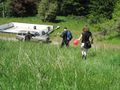
We returned to Booth Canal Road, which turned into Rainbow Road. It was long and winding, but no one threw turtles at us and we were soon within three hundred metres of the geohash, with an unmarked gravel road leading towards it. Rhonda pulled in, and we came up alongside an old cement foundation, possibly the remains of a house that had been entirely destroyed, or one that had been abandoned before being built. There was a two-by-four laid across the road, and we interpreted it as the same sort of signal as the length of culvert pipe we encountered in Vernon: someone didn't want us driving up the road. That was okay, because there was a bridge made out of tires across the ditch leading into the field. We parked the car, took all our geohashing supplies, and, with a stupidity distance of 196 metres headed up the bank. (It's always uphill to the geohash).
Our next obstacle was a pond, this time with no bridge, so we decided to edit our stupidity distance slightly and go around the pond. The whole area looked like a piece of mostly abandoned property. A deer was grazing on it, so placidly that someone at first thought it was a dog. It looked up at us and then we realized that it was quite young, a faun, although no longer with its baby spots, and we didn't see the mother.
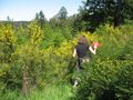
We continued up the hill, and came across the dirt road that had been in the Google Maps view. We hadn't been certain it was a road, or that it would be still there, but here it was, and we knew the geohash was right on it. Elbie was in the lead and continued straight, while others followed the road. Elbie was working her way through small trees and bush and reported a fence at about the same time as the rest of the group met a locked gate. Forty-one metres from the hash. Noooo! They really don't want cars driving on this road. But we're not driving cars. And a little scouting turned up a gap in the fence with a path leading through it. Sweet! Pedestrian access. The fence may have been intended to keep out deer, which eat everything but it wasn't high enough. Deer would jump right over it. It might actually have been for rabbits or chickens: it had closely spaced wire mesh instead of strands. Although Wade said he saw barbed wire, and we have no evidence that he would lie on a geohashing report, do we?
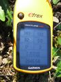
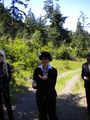
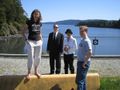
We went through the gap, following the path, but then the path turned the wrong way against a thick line of trees. We dodged one way and another trying to find an easy way through the gorse and young evergreens and then came out on the road beyond the vehicle gate. Elbie and Robyn were both at different points, each clutching a GPS, and started counting off the metres to the geohash with each stride, pacing towards each other and meeting triumphantly as both countdowns reached "one." It was such a great moment in geohashing that we tried to reenact it for the video cameras, but after two takes of attempting to recreate the synchronization we abandoned the effort. Coordinates reached!
Looking for Canal Road
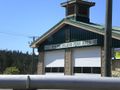
Salt Spring Fire Hall
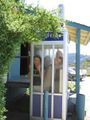
We really do all fit in the phone booth
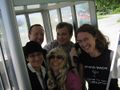
It's just hard to get a camera angle that shows us
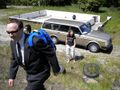
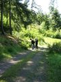
Starting up the bank from the car
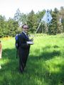
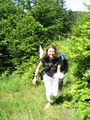
Proudly bearing an xkcd flag
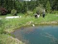
Around the pond
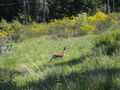
Past the (possibly lethally armed) baby deer
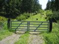
Not this way
But this way
Carrying the cake carefully
Robyn & Elbie collide at the hashpoint


Celebration Time!
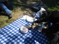
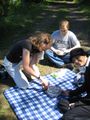
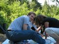
Once the location of the geohash had been well and truly discovered and flagged, we began the Geohashing Day celebration. Wade spread out the picnic blanket on the road next to the xkcd flag, and Rhonda placed the cake in the middle of it. Everyone with cameras took photographs of the cake.
As the celebratory cake was on display, we decided to all work on our circus ribbons. Everyone had a try or three at juggling. Elbie had a golf ball which she augmented with a couple of rocks from the road. Everyone else just picked suitable rocks. We aren't all expert jugglers, which resulted in a few dropped rocks. We were playing on a slope, so the dropped rocks tended to roll and bounce downslope for a bit. After a dramatic moment when a dropped juggling rock bounced over the cake, we realized the potential of gravity, and restricted our juggling to locations downslope of the cake. Xore, Wade and Elbie (and maybe Robyn) earned their ribbons, with Xore and Rhonda working the cameras.
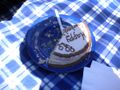
After the successful juggling, we decided to shift our attention to the cake. Yum. Rhonda, as the chef of honour, cut the cake. She cut five generous pieces out of the cake, leaving only the word "Happy" and about 40% of the cake remaining. Each piece was quickly matched with a plate and fork that Xore had thoughtfully provided, and we all enjoyed it. Wade thinks there may have been some peanut in the cake, because he really likes peanut flavoured things, and he really liked the cake, so logically the cake must have been peanut flavoured.
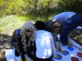
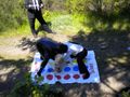
As we were enjoying the cake, there was a brief discussion about the amount of time remaining before we needed to be on a return ferry. We didn't have a lot of time to spare, but we assumed the return journey would be quicker, as we probably wouldn't miss our turn off or pause to stuff a phone booth. Robyn took out the Twister game.
Wade quickly called "Spinner!", to protect everyone else from the danger of him falling on someone else. In addition to his spinner duties, he also collected cameras for incriminating photos. Xore was out first, followed quite a while later by Rhonda. After a long time of spinning and twisting and impressive flexibility and balance, we decided we needed to catch a return ferry, and called it a draw between Robyn and Elbie.
Proof that we made the coordinates
Our view from the side of the hill
If you juggle well enough to be caught on camera ...

... you qualify for the achievement, we decided
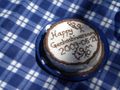
The Geohashiversary Cake
Looked so good even T-Rex wanted to eat it
Rhonda cut the cake
And we devoured it
Wade's quickly volunteered to spin
While the rest of us twisted
And twisted
Until we had to call a draw
Wade, Rhonda, Robyn, Elbie (Xore is taking the photo)
We didn't forget party balloons


Ferry Back to Vancouver
The reverse course (down the road, through the bush, through the gap in the fence along the path the whole way back to the car) was, as always easier than the way in, and despite choosing a different route back to the ferry, there were no more wrong turns, and one more phone booth. Cellular service must have come only recently to the island.
We even managed to queue up at the correct ferry terminal. Return fare, for some reason, was half the outgoing fare. Possibly they forgot to charge us for the vehicle. We didn't ask. We had a few minutes to wait for the ferry, so Robyn posed for compromising photographs and we milled around and took pictures of things until a ferry worker asked us to please move over there so she could load the cars. "In that case," we told her, "we'll go back to our car."
"Didn't you hear the announcement?" She asked. And then when we told her no, she admitted, "Hmm, I didn't hear one either." She had her colleague repeat the announcement and that one was audible and perfectly intelligible. I guess you can't get high quality modern garbling on a remote island, so you have to resort to the speaker not working at all from time to time.
We were again loaded on the top deck, and again established ourselves at a good set of tables, where Citadels was the game of choice. Players have gold pieces to spend, various edifices (depicted on cards) to spend them installing, and take turns playing different roles within the city, giving them varying advantages and strategies. There were fewer doomsday weapons than in the bunnies game. Xore won, amassing 33 points with his eight buildings.
Napping occurred, then we pulled up to the Tsawwassen terminal and everyone drove off the ferry. No mishaps occurred on the way home, and with five humans and a dinosaur in Rhonda's car, we got to rock the HOV lane to the tunnel. Robyn even got home to find a hashcard from ilpadre in her mailbox. What better day for it to arrive?
Rhonda looking for the path back
There is always an easy path back from the geohash
This one goes all the way back to the car
Rainbow Road took us back to Ganges
Following signs to the right ferry terminal
Did Elbie lose a bet? Or is this just her share of the ferry tolls?
Waiting for the ferry at Long Harbour
Taking pictures of us taking pictures of each other
Robyn trying to be risqué

Yuck, is that the best picture of us?
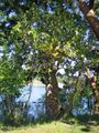
Arbutus tree for Juventas' Flora gallery

There's the ferry at the ramp
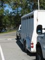
The contents of this truck mooed very loudly as we walked by.
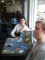
A game of Citadels
Rhonda heading home after the UBC drop off point


Improvements for Next Year's Geohashing Day
- If the home graticule coordinates don't work, check all surrounding graticules to find the best location, rather than just the first accessible.
- Bring brightly coloured juggling implements
- Should we try to set a record by spending more than seven and a half hours on ferries or in ferry line-ups, or should we try and spend less time on ferries? -Robyn 18:00, 22 May 2009 (UTC)
Ribbons
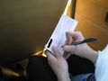
Elbie is free to re-sort them by colour if she wishes.
We All earned the Land geohash achievement
|
We All earned the Phonebooth stuffing achievement
|
Wade, Xore & Elbie earned the Circus Geohash Achievement
|
Wade & Elbie earned the Formal attire achievement
|
Robyn earned the Calendar girl achievement
|
We All earned the Picnic achievement
|
We All earned the Twister Geohash Achievement
|
We All earned the 2009 Geohashing Day achievement
|
- Meetup on 2009-05-21
- Meetup in 48 -123
- Land geohash achievement
- Phonebooth stuffing achievement
- Circus geohash achievement
- Formal attire achievement
- Calendar girl achievement
- Picnic achievement
- Twister geohash achievement
- Geohashing Day achievement
- Expeditions
- Coordinates reached
- Elbie
- Meetup in the Capital Regional District