2009-07-27 51 -0
| Mon 27 Jul 2009 in 51,-0: 51.9943346, -0.4974004 geohashing.info google osm bing/os kml crox |
Location
Flitwick, near Luton
Participants
Plans
I don't know what time I'll be there, as I am en route on a long journey so I won't be stopping for long. --macronencer 16:05, 24 July 2009 (UTC)
Expedition
Having already stopped off at my Origin Geohash and had a roaring success there, I was in high spirits as I drove towards the Luton area (avoiding the M25 as I knew it had roadworks, so it took a couple of hours). About 30 minutes out from the hash point, the heavens opened. It was like a waterfall! By the time I reached Flitwick the whole town was awash with drainage overflow and it was tricky driving round the puddles into oncoming traffic. Leaving Flash-Flooded Flitwick, I passed the hash point and found a parking opportunity in a local garden centre.
There, I consulted Weather Pro, one of my most-valued iPhone apps, and was able to play the radar animation from the last few hours. From this, I could see that the rain was soon to stop, and would perhaps start again about an hour later. Sure enough, almost (but not quite) like that scene in Back To The Future Part 2, the rain stopped and the sun came out. I had already given up on obtaining the Speed racer achievement, as the wet road and the lack of a sufficient length of straight road would have made 60mph a bit dangerous.
I set off towards the hash, some 400m away. I was delighted to find that the entire route sported a pavement. I would not have relished walking down the road dodging cars with all those puddles about! On the way, I passed an interesting bridge (see photos).
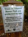
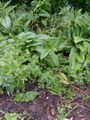
There were lots of trees around, and the GPS was intermittent. Luckily there was a reasonable signal in the vicinity of the target. I was not certain but I judged that the actual hash point was in the bushes next to the road (so the Speed racer achievement would have been dubious anyway). Carefully, I tried the undergrowth with my boot. It seemed solid enough, so I went slightly further in. At one point I realised that there was probably a stream underneath, so I stopped. The GPS still read 0.01km, which it frequently does even exactly in the right place, so I call that a win.
Returning to the car, I marveled at the weather. I had been so lucky to have rain almost all day, but fine weather during the actual hashes. I set off for the final event of the day, at Romsey.
Photos

Our generous parking providers for today
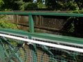
Interesting old bridge...
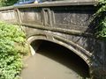
built in 1918
So that's where I am!
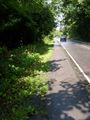
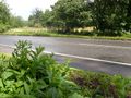
Given the roadside puddles and traffic, VERY glad to see this pavement!
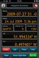
Proof part I
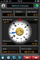
Proof part II
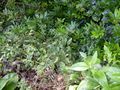
It's just beyond that ditch...
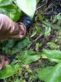
My stupidity radius comes into play. I think I got very close.
View from the hash point

Stupid grin
Leaving a marker
Marker


Achievements
Macronencer achieved level 2 of the Minesweeper Geohash achievement
|
Macronencer earned the Two to the N achievement
|
Macronencer earned the Two to the N achievement
|