Difference between revisions of "2015-08-01 52 0"
From Geohashing
imported>Sourcerer m ([live picture] I didn't make this track. [http://www.openstreetmap.org/?lat=52.26781011&lon=.78932047&zoom=16&layers=B000FTF @52.2678,.7893]) |
imported>Sourcerer m (→New expedition) |
||
| Line 20: | Line 20: | ||
== Expedition == | == Expedition == | ||
| + | *Arrived. -- [[User:Sourcerer|Sourcerer]] ([[User talk:Sourcerer|talk]]) [http://www.openstreetmap.org/?lat=52.26790130&lon=.78906298&zoom=16&layers=B000FTF @52.2679,.7891] 23:01, 1 August 2015 (GMT+01:00) | ||
| + | This one was easy. The hashpoint was about 12 metres from the field perimeter. Normally I would not have closed the final distance but today there was already a well trodden path. It's that ninja hasher again! Or maybe deer tracks because there were several similar paths that did not lead to the hashpoint. | ||
| − | |||
| − | |||
== Photos == | == Photos == | ||
<gallery perrow="5"> | <gallery perrow="5"> | ||
| − | |||
Image:2015-08-01_52_0_Sourcerer_1438466425917.jpg | Proof. [http://www.openstreetmap.org/?lat=52.26790130&lon=.78906834&zoom=16&layers=B000FTF @52.2679,.7891] | Image:2015-08-01_52_0_Sourcerer_1438466425917.jpg | Proof. [http://www.openstreetmap.org/?lat=52.26790130&lon=.78906834&zoom=16&layers=B000FTF @52.2679,.7891] | ||
| − | |||
Image:2015-08-01_52_0_Sourcerer_1438466552614.jpg | I didn't make this track. [http://www.openstreetmap.org/?lat=52.26781011&lon=.78932047&zoom=16&layers=B000FTF @52.2678,.7893] | Image:2015-08-01_52_0_Sourcerer_1438466552614.jpg | I didn't make this track. [http://www.openstreetmap.org/?lat=52.26781011&lon=.78932047&zoom=16&layers=B000FTF @52.2678,.7893] | ||
| + | Image:2015-08-01_52_0_Sourcerer.jpg | Track in Google Earth | ||
</gallery> | </gallery> | ||
== Achievements == | == Achievements == | ||
{{#vardefine:ribbonwidth|700px}} | {{#vardefine:ribbonwidth|700px}} | ||
| + | {{consecutive geohash 2 | ||
| + | | count = 9 | ||
| + | | latitude = 52 | ||
| + | | longitude = 1 | ||
| + | | date = 2015-07-24 | ||
| + | | name = Sourcerer | ||
| + | }} | ||
{{Sourcerer_links | {{Sourcerer_links | ||
| Line 42: | Line 48: | ||
| date = 2015-08-01 | | date = 2015-08-01 | ||
}} | }} | ||
| − | + | ||
| − | |||
[[Category:Expeditions]] | [[Category:Expeditions]] | ||
[[Category:Expeditions with photos]] | [[Category:Expeditions with photos]] | ||
[[Category:Coordinates reached]] | [[Category:Coordinates reached]] | ||
| − | |||
Revision as of 01:16, 2 August 2015
| Sat 1 Aug 2015 in 52,0: 52.2679079, 0.7890831 geohashing.info google osm bing/os kml crox |
Location
A field perimeter east of Great Barton, 1.3km from 2015-02-11 52 0, Suffolk, UK.
Participants
Plans
Expedition one of two spanning midnight - 2015-08-01 52 0 - 2015-08-02 52 0 - ETA 23:00.
Expedition
- Arrived. -- Sourcerer (talk) @52.2679,.7891 23:01, 1 August 2015 (GMT+01:00)
This one was easy. The hashpoint was about 12 metres from the field perimeter. Normally I would not have closed the final distance but today there was already a well trodden path. It's that ninja hasher again! Or maybe deer tracks because there were several similar paths that did not lead to the hashpoint.
Photos
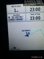
Proof. @52.2679,.7891
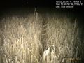
I didn't make this track. @52.2678,.7893
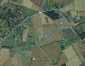
Track in Google Earth


Achievements
Sourcerer earned the Consecutive geohash achievement
|
Expeditions and Plans
| 2015-08-01 | ||
|---|---|---|
| Buffalo, New York | Pedalpusher, Simon the dog, Myka the dog | In the woods, by Dobbins Memorial State Park |
| Sankt Pölten, Austria | Micsnare | Thwarted with B2c and Crankl ;( -- Micsnare (talk) @48.0010,14.7064 00:57,... |
| Cottbus, Germany | StefanC | First Hash in a while. Reached using my bike and a lot of sweat because of ... |
| Kassel, Germany | GeorgDerReisende | The hash lies on a meadow above Großalmerode. |
| Cambridge, United Kingdom | Sourcerer | A field perimeter east of Great Barton, 1.3km from 2015-02-11 52 0, Suffolk, UK. |
| Hannover, Germany | Fippe | located on a field of wheat near Pattensen. |
Sourcerer's Expedition Links
2015-07-31 52 1 - 2015-08-01 52 0 - 2015-08-02 52 0 - KML file download of Sourcerer's expeditions for use with Google Earth.