Difference between revisions of "2015-10-22 52 0"
From Geohashing
imported>Sourcerer m ([live picture] Proof. [http://www.openstreetmap.org/?lat=52.22645581&lon=.90576053&zoom=16&layers=B000FTF @52.2265,.9058]) |
imported>Sourcerer m (→New expedition) |
||
| Line 20: | Line 20: | ||
== Expedition == | == Expedition == | ||
| + | *Arrived. -- [[User:Sourcerer|Sourcerer]] ([[User talk:Sourcerer|talk]]) [http://www.openstreetmap.org/?lat=52.22644508&lon=.90576053&zoom=16&layers=B000FTF @52.2264,.9058] 00:13, 22 October 2015 (GMT+01:00) | ||
| + | There was space to park in the field entrance. A perimeter track led in the right direction. The hashpoint was a few paces into the recently cultivated field. The ground was a bit soggy. No seedlings were visible though. | ||
| − | |||
| − | |||
== Photos == | == Photos == | ||
<gallery> | <gallery> | ||
| − | |||
Image:2015-10-22_52_0_Sourcerer_1445469191613.jpg | Proof. [http://www.openstreetmap.org/?lat=52.22645581&lon=.90576053&zoom=16&layers=B000FTF @52.2265,.9058] | Image:2015-10-22_52_0_Sourcerer_1445469191613.jpg | Proof. [http://www.openstreetmap.org/?lat=52.22645581&lon=.90576053&zoom=16&layers=B000FTF @52.2265,.9058] | ||
| + | Image:2015-10-22_52_0_Sourcerer.jpg | Track in Google Earth | ||
</gallery> | </gallery> | ||
| Line 47: | Line 47: | ||
}} | }} | ||
| − | |||
| − | |||
[[Category:Expeditions]] | [[Category:Expeditions]] | ||
[[Category:Expeditions with photos]] | [[Category:Expeditions with photos]] | ||
[[Category:Coordinates reached]] | [[Category:Coordinates reached]] | ||
| − | |||
Revision as of 00:51, 22 October 2015
| Thu 22 Oct 2015 in 52,0: 52.2264413, 0.9058017 geohashing.info google osm bing/os kml crox |
Location
In a field north of the A14 between Woolpit and Elmswell, Suffolk, UK.
Participants
Plans
Expedition three of three spanning midnight - 2015-10-21 52 1 - 2015-10-21 52 0 - 2015-10-22 52 0 - ETA 00:00.
Expedition
- Arrived. -- Sourcerer (talk) @52.2264,.9058 00:13, 22 October 2015 (GMT+01:00)
There was space to park in the field entrance. A perimeter track led in the right direction. The hashpoint was a few paces into the recently cultivated field. The ground was a bit soggy. No seedlings were visible though.
Photos
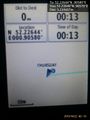
Proof. @52.2265,.9058
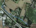
Track in Google Earth


Achievements
Sourcerer earned the Midnight Geohash achievement
|
Expeditions and Plans
| 2015-10-22 | ||
|---|---|---|
| Wellington, New Zealand | Quaternary | Lower Hutt, Wellington, NZ |
| Tri Cities, Washington | Thomcat | Near Road 12, east of Royal. |
| Cambridge, United Kingdom | Sourcerer | 3) In a field north of the A14 between Woolpit and Elmswell, Suffolk, UK. |
| Hannover, Germany | GlobeCacher.de | A waste acre between Sarstedt and Klein Förste |
| Keuruu, Finland | Tilley | In Selkäinniemi, Asunta, Keuruu. The point lies in the forest. |
Sourcerer's Expedition Links
2015-10-21 52 0 - 2015-10-22 52 0 - 2015-10-23 52 1 - KML file download of Sourcerer's expeditions for use with Google Earth.