Difference between revisions of "New Zealand"
Quaternary (talk | contribs) (→Graticule Map) |
|||
| (9 intermediate revisions by 4 users not shown) | |||
| Line 1: | Line 1: | ||
| − | '''New Zealand''' is in the southern Pacific Ocean. It | + | '''New Zealand''' (Aotearoa in Māori) is in the southern Pacific Ocean. It is an island country comprising two main landmasses (the North Island and the South Island) and numerous smaller islands. The country is situated some 1,500 kilometres (900 mi) east of Australia across the Tasman Sea, and roughly 1,000 kilometres (600 mi) south of the Pacific island nations of New Caledonia, Fiji, and Tonga. Due to its remoteness, it was one of the last lands to be settled by humans. During its long isolation New Zealand developed a distinctive fauna dominated by birds, many of which became extinct after the arrival of humans and introduced mammals. With a mild maritime climate, the land was mostly covered in forest. The country's varied topography and its sharp mountain peaks owe much to the uplift of land and volcanic eruptions caused by the Pacific and Indo-Australian Plates clashing underfoot. |
| + | It consists of 66 [[Graticule|graticules]] (71 Graticules Including Chatham, Auckland and Campbell Islands). | ||
| + | [[File:New_Zealand_02_05_2011.JPG|right|thumb|New Zealand from above|350px]] | ||
| + | |||
| + | |||
| + | ==Information== | ||
| + | As at 5:48pm 24/12/08 Local time, there are 35 Geohashers registered as being in New Zealand, coming to mean that 0.000815428656% of New Zealanders are involved in Geohashing. It is also better than its neighbour [[Australia]]. Graticules that have pages can be found [[:Category:New Zealand|here]]. | ||
| + | [[Image:New Zealand.JPG|thumb|New Zealand, better than [[Australia]].]] | ||
| + | |||
| + | ==Achievement Awarded== | ||
{{A Tale of Two Hashes challenge | {{A Tale of Two Hashes challenge | ||
| Line 20: | Line 29: | ||
}} | }} | ||
| − | + | ||
| − | |||
| − | |||
==Graticule Map== | ==Graticule Map== | ||
| Line 65: | Line 72: | ||
|[[Image:Mindsweeper_blue.jpg]] | |[[Image:Mindsweeper_blue.jpg]] | ||
|[[Image:Minesweeper_geohash_cherry.png|link=Northland, New Zealand]] | |[[Image:Minesweeper_geohash_cherry.png|link=Northland, New Zealand]] | ||
| − | |[[Image: | + | |[[Image:Minesweeper_geohash_flag.png|link=Whangarei, New Zealand]] |
|[[Image:Mindsweeper_blue.jpg]] | |[[Image:Mindsweeper_blue.jpg]] | ||
|[[Image:Mindsweeper_blue.jpg]] | |[[Image:Mindsweeper_blue.jpg]] | ||
| Line 81: | Line 88: | ||
|[[Image:Minesweeper_geohash_cherry.png|link=Glinks Gully, New Zealand]] | |[[Image:Minesweeper_geohash_cherry.png|link=Glinks Gully, New Zealand]] | ||
|[[Image:Minesweeper_geohash_flag.jpg|link=Auckland, New Zealand]] | |[[Image:Minesweeper_geohash_flag.jpg|link=Auckland, New Zealand]] | ||
| − | |[[Image: | + | |[[Image:Minesweeper_geohash_flag.png|link=Coromandel, New Zealand]] |
|[[Image:Mindsweeper_blue.jpg]] | |[[Image:Mindsweeper_blue.jpg]] | ||
|[[Image:Mindsweeper_blue.jpg]] | |[[Image:Mindsweeper_blue.jpg]] | ||
| Line 97: | Line 104: | ||
|[[Image:Minesweeper_geohash_flag.jpg|link=Manukau City, New Zealand]] | |[[Image:Minesweeper_geohash_flag.jpg|link=Manukau City, New Zealand]] | ||
|[[Image:Minesweeper_geohash_flag.jpg|link=Hamilton, New Zealand]] | |[[Image:Minesweeper_geohash_flag.jpg|link=Hamilton, New Zealand]] | ||
| − | |[[Image: | + | |[[Image:Minesweeper_geohash_flag.jpg|link=Tauranga, New Zealand]] |
|[[Image:Minesweeper_geohash_cherry.png|link=Waiorore, New Zealand]] | |[[Image:Minesweeper_geohash_cherry.png|link=Waiorore, New Zealand]] | ||
|[[Image:Minesweeper_geohash_cherry.png|link=Ruatoria, New Zealand]] | |[[Image:Minesweeper_geohash_cherry.png|link=Ruatoria, New Zealand]] | ||
| Line 126: | Line 133: | ||
|[[Image:Minesweeper_geohash_cherry.png|link=Opunake, New Zealand]] | |[[Image:Minesweeper_geohash_cherry.png|link=Opunake, New Zealand]] | ||
|[[Image:Minesweeper_geohash_cherry.png|link=New Plymouth, New Zealand]] | |[[Image:Minesweeper_geohash_cherry.png|link=New Plymouth, New Zealand]] | ||
| − | |[[Image: | + | |[[Image:Minesweeper_geohash_flag.jpg|link=Wanganui, New Zealand]] |
|[[Image:Minesweeper_geohash_cherry.png|link=Napier, New Zealand]] | |[[Image:Minesweeper_geohash_cherry.png|link=Napier, New Zealand]] | ||
|[[Image:Minesweeper_geohash_cherry.png|link=Wairoa, New Zealand]] | |[[Image:Minesweeper_geohash_cherry.png|link=Wairoa, New Zealand]] | ||
| Line 153: | Line 160: | ||
|[[Image:Mindsweeper_blue.jpg]] | |[[Image:Mindsweeper_blue.jpg]] | ||
|[[Image:Minesweeper_geohash_cherry.png|link=Westport, New Zealand]] | |[[Image:Minesweeper_geohash_cherry.png|link=Westport, New Zealand]] | ||
| − | |[[Image: | + | |[[Image:Minesweeper_geohash_flag.png|link=Motueka, New Zealand]] |
|[[Image:Minesweeper_geohash_cherry.png|link=Nelson, New Zealand]] | |[[Image:Minesweeper_geohash_cherry.png|link=Nelson, New Zealand]] | ||
|[[Image:Minesweeper_geohash_flag.jpg|link=Wellington, New Zealand]] | |[[Image:Minesweeper_geohash_flag.jpg|link=Wellington, New Zealand]] | ||
| Line 182: | Line 189: | ||
|[[Image:Minesweeper_geohash_cherry.png|link=Haast, New Zealand]] | |[[Image:Minesweeper_geohash_cherry.png|link=Haast, New Zealand]] | ||
|[[Image:Minesweeper_geohash_cherry.png|link=Mount Cook, New Zealand]] | |[[Image:Minesweeper_geohash_cherry.png|link=Mount Cook, New Zealand]] | ||
| − | |[[Image: | + | |[[Image:Minesweeper_geohash_flag.jpg|link=Ashburton, New Zealand]] |
|[[Image:Minesweeper_geohash_flag.jpg|link=Christchurch, New Zealand]] | |[[Image:Minesweeper_geohash_flag.jpg|link=Christchurch, New Zealand]] | ||
| − | |[[Image: | + | |[[Image:Minesweeper_geohash_flag.jpg|link=Le Bons Bay, New Zealand]] |
|[[Image:Mindsweeper_blue.jpg]] | |[[Image:Mindsweeper_blue.jpg]] | ||
|[[Image:Mindsweeper_blue.jpg]] | |[[Image:Mindsweeper_blue.jpg]] | ||
| Line 196: | Line 203: | ||
|[[Image:Minesweeper_geohash_cherry.png|link=Arrowtown, New Zealand]] | |[[Image:Minesweeper_geohash_cherry.png|link=Arrowtown, New Zealand]] | ||
|[[Image:Minesweeper_geohash_cherry.png|link=Wanaka, New Zealand]] | |[[Image:Minesweeper_geohash_cherry.png|link=Wanaka, New Zealand]] | ||
| − | |[[Image: | + | |[[Image:Minesweeper_geohash_flag.png|link=Waitaki River, New Zealand]] |
| − | |[[Image: | + | |[[Image:Minesweeper_geohash_flag.png|link=Timaru, New Zealand]] |
|[[Image:Mindsweeper_blue.jpg]] | |[[Image:Mindsweeper_blue.jpg]] | ||
|[[Image:Mindsweeper_blue.jpg]] | |[[Image:Mindsweeper_blue.jpg]] | ||
| Line 211: | Line 218: | ||
|[[Image:Minesweeper_geohash_cherry.png|link=Queenstown, New Zealand]] | |[[Image:Minesweeper_geohash_cherry.png|link=Queenstown, New Zealand]] | ||
|[[Image:Minesweeper_geohash_cherry.png|link=Central Otago, New Zealand]] | |[[Image:Minesweeper_geohash_cherry.png|link=Central Otago, New Zealand]] | ||
| − | |[[Image: | + | |[[Image:Minesweeper_geohash_flag.jpg|link=Dunedin, New Zealand]] |
|[[Image:Minesweeper_geohash_cherry.png|link=Richmond, New Zealand]] | |[[Image:Minesweeper_geohash_cherry.png|link=Richmond, New Zealand]] | ||
|[[Image:Mindsweeper_blue.jpg]] | |[[Image:Mindsweeper_blue.jpg]] | ||
| Line 344: | Line 351: | ||
*[[User:Krintar|Krintar]] | *[[User:Krintar|Krintar]] | ||
*[[User:Poshepocket|Poshepocket]] | *[[User:Poshepocket|Poshepocket]] | ||
| + | *[[User:Jacksonz|Jacksonz]] | ||
===[[Manukau City, New Zealand|Manukau City]]=== | ===[[Manukau City, New Zealand|Manukau City]]=== | ||
| Line 382: | Line 390: | ||
*[[User:Maksymilian|Maksymilian]] | *[[User:Maksymilian|Maksymilian]] | ||
*[[User:Rabid-Monkey|Rabid-Monkey]] | *[[User:Rabid-Monkey|Rabid-Monkey]] | ||
| + | *[[User:Quaternary|Quaternary]] | ||
===[[The Catlins, New Zealand|The Catlins]]=== | ===[[The Catlins, New Zealand|The Catlins]]=== | ||
*[[User:Rabid-Monkey|Rabid-Monkey]] | *[[User:Rabid-Monkey|Rabid-Monkey]] | ||
[[Category:Australasia]] | [[Category:Australasia]] | ||
Latest revision as of 04:39, 9 December 2023
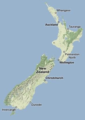
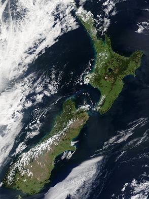
New Zealand (Aotearoa in Māori) is in the southern Pacific Ocean. It is an island country comprising two main landmasses (the North Island and the South Island) and numerous smaller islands. The country is situated some 1,500 kilometres (900 mi) east of Australia across the Tasman Sea, and roughly 1,000 kilometres (600 mi) south of the Pacific island nations of New Caledonia, Fiji, and Tonga. Due to its remoteness, it was one of the last lands to be settled by humans. During its long isolation New Zealand developed a distinctive fauna dominated by birds, many of which became extinct after the arrival of humans and introduced mammals. With a mild maritime climate, the land was mostly covered in forest. The country's varied topography and its sharp mountain peaks owe much to the uplift of land and volcanic eruptions caused by the Pacific and Indo-Australian Plates clashing underfoot.
It consists of 66 graticules (71 Graticules Including Chatham, Auckland and Campbell Islands).
Contents
[hide]Information
As at 5:48pm 24/12/08 Local time, there are 35 Geohashers registered as being in New Zealand, coming to mean that 0.000815428656% of New Zealanders are involved in Geohashing. It is also better than its neighbour Australia. Graticules that have pages can be found here.

Achievement Awarded
Hessophanes, Hiro, JUB and relet issued a challenge for the Tale of Two Hashes achievement
|
Greenslime & JimmyNZ earned the Tale of Two Hashes achievement
|
Graticule Map
Graticules
They go in order from left to right, top to bottom.
- -34, 172 - Cape Reigna
- -34, 173 - Rangiputa
- -35, 173 - Northland
- -35, 174 - Whangarei
- -35, 175 - Mokohinau Islands
- -36, 173 - Glinks Gully
- -36, 174 - Auckland
- -36, 175 - Coromandel
- -36, 176 - The Alderman Islands
- -37, 174 - Manukau City
- -37, 175 - Hamilton
- -37, 176 - Tauranga
- -37, 177 - Waiorore
- -37, 178 - Ruatoria
- -38, 174 - Waitara
- -38, 175 - South Waikato
- -38, 176 - Rotorua
- -38, 177 - Opotiki
- -38, 178 - Gisborne
- -39, 173 - Opunake
- -39, 174 - New Plymouth
- -39, 175 - Wanganui
- -39, 176 - Napier
- -39, 177 - Wairoa
- -39, 178 - Table Cape
- -40, 172 - Golden Bay
- -40, 173 - D'Urville Island
- -40, 174 - Paraparaumu
- -40, 175 - Palmerston North
- -40, 176 - Waipukurau
- -41, 171 - Westport
- -41, 172 - Motueka
- -41, 173 - Nelson
- -41, 174 - Wellington
- -41, 175 - Upper Hutt
- -41, 176 - Riversdale Beach
- -42, 170 - Hokitika
- -42, 171 - Greymouth
- -42, 172 - Hanmer Springs
- -42, 173 - Kaikoura
- -42, 174 - Kekerengu
- -43, 168 - Hannah's Clearing
- -43, 169 - Haast
- -43, 170 - Mount Cook
- -43, 171 - Ashburton
- -43, 172 - Christchurch
- -43, 173 - Le Bons Bay
- -43, -176 - Chatham Island
- -44, 167 - Milford Sound
- -44, 168 - Arrowtown
- -44, 169 - Wanaka
- -44, 170 - Waitaki River
- -44, 171 - Timaru
- -44, -176 - Pitt Island
- -45, 166 - Resolution Island
- -45, 167 - Te Anau
- -45, 168 - Queenstown
- -45, 169 - Central Otago
- -45, 170 - Dunedin
- -45, 171 - Richmond
- -46, 166 - South-West Fiordland National Park
- -46, 167 - Te Waewae Bay
- -46, 168 - Invercargill
- -46, 169 - The Catlins
- -46, 170 - Waihola
- -47, 167 - South-West Stewart Island
- -47, 168 - East Stewart Island
- -50, 165 - West Auckland Island
- -50, 166 - East Auckland Island
- -52, 169 - Campbell Island
Locals
Auckland
- Cascade
- Halkyardo
- jinerviet
- gnail
- bobilljim
- Eb
- wipash
- Zaf
- TunezNZ
- Khadgar
- Aspirin
- Greenslime
- JimmyNZ
- Krintar
- Poshepocket
- Jacksonz
Manukau City
Hamilton
Palmerston North
Wellington
Nelson
Christchurch
- Phire
- sarah_briarmoss
- Super_ben
- ecksoh
- gregh
- Evil Monkey
- Yellow Onion
- UCanDance
- Gorgoth
- ForkInTheSocket
- Maksymilian
- Rabid-Monkey
- Quaternary
