Difference between revisions of "2010-08-01 49 8"
From Geohashing
imported>Koepfel (reporting a half-year-old expedition...) |
m (Location correction) |
||
| (2 intermediate revisions by 2 users not shown) | |||
| Line 30: | Line 30: | ||
File:2010-08-01_49_8-4revisit.jpg|The powerline seen in [[:File:2009-03-16 49 8.jpg|2009-03-16 49 8]] | File:2010-08-01_49_8-4revisit.jpg|The powerline seen in [[:File:2009-03-16 49 8.jpg|2009-03-16 49 8]] | ||
</gallery> | </gallery> | ||
| + | |||
| + | {{consecutive geohash | count = 4 | latitude = 49 | longitude = 8 | date = 2010-07-30 | name = Koepfel }} | ||
| + | [[2010-07-30 49 8|Büchelberg]], [[2010-07-31 49 8|Wörth]], [[2010-08-01 49 8|Oberhausen-Rheinhausen]], [[2010-08-02 49 8|Plankstadt]] | ||
[[category:Expeditions]] | [[category:Expeditions]] | ||
[[Category:Coordinates reached]] | [[Category:Coordinates reached]] | ||
[[Category:Expeditions with photos]] | [[Category:Expeditions with photos]] | ||
| + | {{location|DE|BW|KA}} | ||
Latest revision as of 20:04, 16 May 2020
| Sun 1 Aug 2010 in 49,8: 49.2756420, 8.4991637 geohashing.info google osm bing/os kml crox |
Location
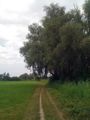
Near the Erlichsee, a lake near Oberhausen-Rheinhausen.
Participants
Plans
Near a lake near Oberhausen-Rheinhausen. Pretty close to 2009-03-16 49 8. Plan to be there around 15:00 or something. Koepfel talk 19:17, 31 July 2010 (UTC)
How to get there: Train to Waghäusel, bus 128 to Oberhausen, Kirchplatz, walk from there.
Expedition Report
Koepfel
Was there at 14:30, also revisited 2009-03-16 49 8
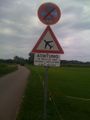
Beware of model airplanes.
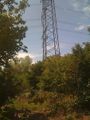
The powerline seen in 2009-03-16 49 8


Koepfel earned the Consecutive geohash achievement
|