Difference between revisions of "2012-09-02 52 0"
imported>Sourcerer m (→Planning an Expedition) |
imported>FippeBot m (Location) |
||
| (12 intermediate revisions by one other user not shown) | |||
| Line 1: | Line 1: | ||
| − | |||
| − | |||
| − | |||
| − | |||
| − | |||
| − | |||
| − | |||
| − | |||
| − | |||
| − | |||
{{meetup graticule | {{meetup graticule | ||
| − | | lat=52 | + | | lat=52 |
| − | | lon=0 | + | | lon=0 |
| − | | date=2012-09-02 | + | | date=2012-09-02 |
| + | | graticule_name=Cambridge | ||
| + | | graticule_link=Cambridge, United Kingdom | ||
}} | }} | ||
| − | |||
| − | |||
== Location == | == Location == | ||
| − | + | ||
| + | On the mud flats near Stiffkey, north Norfolk, UK. Caution: This can only be reached at low tide. | ||
== Participants == | == Participants == | ||
| − | + | ||
| − | + | [[User:Sourcerer|Sourcerer]] | |
== Plans == | == Plans == | ||
| − | + | ||
| + | Here is a third hashpoint on the mud flats near Stiffkey, north Norfolk, UK. This will be a double déjà vu geohash as it's only 800 metres from [[2012-08-08_52_0]] and the route to reach it is almost identical to the [[2011-06-26_52_0]] expedition. On this expedition, I'll attempt to avoid the soaking, drowning risk and technology shorted out by salt water of the earlier expeditions. The hashpoint will be dry enough for a 4pm meetup. Bring razor shells for the xkcd marker. You'll need to paddle through black anaerobic mud and wade across a tidal creek. | ||
| + | |||
| + | [[File:2012-09-02 52 0 Sourcerer Tides.jpg]] | ||
| + | |||
| + | Here is the déjà vu evidence showing track logs. Today's track is red. [[2012-08-08_52_0]] is blue and [[2011-06-26_52_0]] is lime green. | ||
| + | |||
| + | [[File:2012-09-02 52 0 Sourcerer Deja Vu.jpg]] | ||
== Expedition == | == Expedition == | ||
| − | |||
| − | == | + | *Arrived. -- [[User:Sourcerer|Sourcerer]] [http://www.openstreetmap.org/?lat=52.969953417778015&lon=0.9190160036087036&zoom=16&layers=B000FTF @52.9700,.9190] 16:05, 02 September 2012 (GMT+01:00) |
| − | + | ||
| + | There was little excitement today compared with the earlier expeditions. The creek wade was not too deep and I kept the electronics dry. The walk was shorter too as the hashpoint was nearer the car park. The weather was warm, dry but dull so the photos of the two earlier expeditions are recommended. | ||
| + | |||
| + | There was a tiny desert island forming a few metres from the hashpoint. Marram grass had trapped wind blown sand. With the correct combination of wind and lack of storms, this could grow into a sand dune. More likely it'll be washed away in the winter storms. Sadly it's too cold for coconut palms. | ||
== Photos == | == Photos == | ||
| − | + | ||
| − | |||
| − | |||
<gallery perrow="5"> | <gallery perrow="5"> | ||
| + | Image:2012-09-02_52_0_16-07-07-765.jpg | [http://www.openstreetmap.org/?lat=52.969948053359985&lon=0.9189891815185547&zoom=16&layers=B000FTF @52.9699,.9190] | ||
| + | Image:2012-09-02 52 0 Sourcerer Desert Island.jpg|Desert Island Forming | ||
</gallery> | </gallery> | ||
== Achievements == | == Achievements == | ||
{{#vardefine:ribbonwidth|800px}} | {{#vardefine:ribbonwidth|800px}} | ||
| − | |||
| + | An unusual double déjà vu geohash. | ||
| − | + | {{Déjà vu geohash | |
| − | + | | latitude = 52 | |
| − | + | | longitude = 0 | |
| + | | date = 2012-09-02 | ||
| + | | olddate = 2012-08-08 | ||
| + | | name = Sourcerer | ||
| + | }} | ||
| + | {{Déjà vu geohash | ||
| + | | latitude = 52 | ||
| + | | longitude = 0 | ||
| + | | date = 2012-09-02 | ||
| + | | olddate = 2011-06-26 | ||
| + | | name = Sourcerer | ||
| + | }} | ||
| − | + | {{Sourcerer_links | |
| − | + | | prev = 2012-08-16 52 1 | |
| − | + | | curr = 2012-09-02 52 0 | |
| − | -- | + | | next = 2012-09-14 52 1 |
| + | | date = 2012-09-02 | ||
| + | }} | ||
| − | |||
[[Category:Expeditions]] | [[Category:Expeditions]] | ||
| − | |||
[[Category:Expeditions with photos]] | [[Category:Expeditions with photos]] | ||
| − | |||
| − | |||
| − | |||
| − | |||
| − | |||
[[Category:Coordinates reached]] | [[Category:Coordinates reached]] | ||
| − | + | {{location|GB|ENG|NFK}} | |
| − | |||
| − | |||
| − | |||
| − | |||
| − | |||
| − | |||
| − | |||
| − | |||
| − | |||
| − | |||
| − | |||
| − | |||
| − | |||
| − | |||
| − | |||
| − | |||
| − | |||
Latest revision as of 05:56, 13 August 2019
| Sun 2 Sep 2012 in Cambridge: 52.9699702, 0.9189871 geohashing.info google osm bing/os kml crox |
Contents
Location
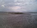
On the mud flats near Stiffkey, north Norfolk, UK. Caution: This can only be reached at low tide.
Participants
Plans
Here is a third hashpoint on the mud flats near Stiffkey, north Norfolk, UK. This will be a double déjà vu geohash as it's only 800 metres from 2012-08-08_52_0 and the route to reach it is almost identical to the 2011-06-26_52_0 expedition. On this expedition, I'll attempt to avoid the soaking, drowning risk and technology shorted out by salt water of the earlier expeditions. The hashpoint will be dry enough for a 4pm meetup. Bring razor shells for the xkcd marker. You'll need to paddle through black anaerobic mud and wade across a tidal creek.

Here is the déjà vu evidence showing track logs. Today's track is red. 2012-08-08_52_0 is blue and 2011-06-26_52_0 is lime green.

Expedition
- Arrived. -- Sourcerer @52.9700,.9190 16:05, 02 September 2012 (GMT+01:00)
There was little excitement today compared with the earlier expeditions. The creek wade was not too deep and I kept the electronics dry. The walk was shorter too as the hashpoint was nearer the car park. The weather was warm, dry but dull so the photos of the two earlier expeditions are recommended.
There was a tiny desert island forming a few metres from the hashpoint. Marram grass had trapped wind blown sand. With the correct combination of wind and lack of storms, this could grow into a sand dune. More likely it'll be washed away in the winter storms. Sadly it's too cold for coconut palms.
Photos
Desert Island Forming


Achievements
An unusual double déjà vu geohash.
Sourcerer earned the Déjà Vu Geohash Achievement
|
Sourcerer earned the Déjà Vu Geohash Achievement
|
Expeditions and Plans
| 2012-09-02 | ||
|---|---|---|
| Portland, Oregon | Jim | In a field near St. Helens |
| Verona, Italy | Werther | On the side of a country road north of Dro, Trento. Easily reachable from L... |
| Brighton, United Kingdom | David Miller, KatieWheatley, Ryan Miller, Chloé Miller | A wooded area just outside of Nursted |
| Southampton, United Kingdom | David Miller, KatieWheatley, Ryan Miller, Chloé Miller | A nature reserver just outside of a little village called Martin. |
| Erfurt, Germany | Juja, Benjy, Frankie Mouse | On a meadow or field between Eisenberg an Etzdorf, easy to reach. |
| Bonn, Germany | QuarterCacher | Somewhere |
| Cambridge, United Kingdom | Sourcerer | On the mud flats near Stiffkey, north Norfolk, UK. Caution: This can only b... |
Sourcerer's Expedition Links
2012-08-16 52 1 - 2012-09-02 52 0 - 2012-09-14 52 1 - KML file download of Sourcerer's expeditions for use with Google Earth.