Difference between revisions of "2023-07-16 45 -122"
Michael5000 (talk | contribs) (Created page with "{{subst:Expedition}}") |
m (subst-ing) |
||
| (15 intermediate revisions by 4 users not shown) | |||
| Line 1: | Line 1: | ||
| − | + | {{meetup graticule | |
| + | | lat=45 | ||
| + | | lon=-122 | ||
| + | | date=2023-07-16 | ||
| + | }} | ||
| + | == Location == | ||
| − | + | In North Kerby Avenue, near Fremont. | |
| − | + | == Participants == | |
| − | |||
| − | |||
| − | |||
| − | |||
| − | |||
| − | |||
| − | |||
| − | |||
| − | = | ||
| − | |||
| − | + | * [[user:Gaelan|Gaelan]], a day early | |
| − | + | * [[user:Michael5000|Michael5000]] | |
| − | + | * [[User:Jiml|Jim]] | |
== Plans == | == Plans == | ||
| − | + | ||
| + | Jim's plan was, when he noticed where the hashpoint was on Friday, was to go by after he went to the American Red Cross | ||
| + | blood bank to donate! | ||
== Expedition == | == Expedition == | ||
| − | |||
| − | == | + | === Gaelan - Expedition 1 === |
| − | + | ||
| + | My family was visiting a friend in Portland on Saturday, and I got a few hours to sneak off and explore. Oh, hey, there's a geohash not too far from here! Let's go up. | ||
| + | |||
| + | Bus, MAX, bus, get the photo, walk over to the Yellow line (through a lovely street party at Fremont & Mississippi) for the MAX back into downtown. Easy. First successful geohash! Didn't have any evidence-leaving supplies with me, so no evidence left. | ||
| + | |||
| + | Several hours later, on the way back up north, take another look at the map. Wait, why are there two pins? Oh right, it's the weekend. Oh my god, I went to Sunday's point. Oh well, I guess this counts as a retro? | ||
| + | |||
| + | (Note by Jim: Yes - any expedition not on the day of the hashpoint counts as a retro!) | ||
| + | |||
| + | === Michael5000 - Expedition 5000 === | ||
| + | |||
| + | I don't usually forget that I'm geohashing when I'm geohashing, but as I peddled past the Lloyd district and up towards Mississippi-Albina I found myself thinking "well, this is a pleasant bike ride, but now where am I going, again?" Well, today's hashpoint was only a few hundred meters from where I was born, so perhaps I was bicycling back towards my birthplace purely on instinct, like a salmon navigating by smell back to the pool where he was hatched. But, well -- probably not. | ||
| + | |||
| + | The hashpoint is on an ordinary residential street. I didn't see any evidence of geohashers before me, and I chided myself for neglecting to bring chalk in case someone came after me. | ||
| + | |||
| + | I continued the bicycle ride to pick up a book at Powell's, and then came home. Total round trip: 11 miles. | ||
| + | |||
| + | === Expedition 3 === | ||
| + | |||
| + | Jim left the bloodbank after he was done (and they were done with him), and was first stopped for a while waiting for a line | ||
| + | Seattle-to-Portland bicycle riders to pass) He went a few blocks and found the hashpoint, and took a few pictures which he | ||
| + | might upload someday. | ||
| + | |||
| + | After he was done, he sat and attempted to update the website from his phone. It didn't work very well, but in the middle | ||
| + | of the update, he discovered that M5000 was putting in his report, but apparently from home. We managed to avoid | ||
| + | an "[[2009-08-29_52_13|edit conflict]]", unlike a previous set of geohashers! :-) | ||
== Photos == | == Photos == | ||
| − | + | ||
| − | |||
| − | |||
<gallery perrow="5"> | <gallery perrow="5"> | ||
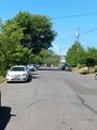
| + | File:2023-07-16 45 -122 a.jpg|View from the hashpoint | ||
| + | File:2023-07-16 45 -122 b.jpg|Me, looking dumb at the hashpoint | ||
| + | File:2023-07-16 45 -122 d.jpg|Evidence | ||
| + | File:2023-07-16 45 -122 c.jpg|View north up the Willamette River, from later in the ride | ||
| + | File:2023-07-16 45 -122 Gaelan b.jpg|Gaelan's Grin(TM), unfortunately a day early | ||
| + | File:2023-07-16 45 -122 Gaelan a.jpg|Gaelan's evidence | ||
</gallery> | </gallery> | ||
== Achievements == | == Achievements == | ||
{{#vardefine:ribbonwidth|100%}} | {{#vardefine:ribbonwidth|100%}} | ||
| − | |||
| − | + | * Land Geohash | |
| − | + | * Bike Geohash | |
| − | |||
| − | |||
| − | + | {{Blinded by Science | |
| + | | latitude = 45 | ||
| + | | longitude = -122 | ||
| + | | date = 2023-07-16 | ||
| + | | reason = through getting there a day early because she can't read a map | ||
| + | | name = Gaelan | ||
| + | }} | ||
| − | + | __NOTOC__ | |
| − | |||
| − | |||
| − | |||
| − | |||
| − | |||
[[Category:Expeditions]] | [[Category:Expeditions]] | ||
| − | |||
| − | |||
| − | |||
| − | |||
| − | |||
| − | |||
| − | |||
[[Category:Coordinates reached]] | [[Category:Coordinates reached]] | ||
| − | + | {{location|US|OR|MU}} | |
| − | |||
| − | |||
| − | |||
| − | |||
| − | |||
| − | |||
| − | |||
| − | |||
| − | |||
| − | |||
| − | |||
| − | |||
| − | |||
| − | |||
| − | |||
| − | |||
Latest revision as of 21:02, 24 May 2024
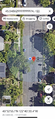
| Sun 16 Jul 2023 in 45,-122: 45.5486252, -122.6723415 geohashing.info google osm bing/os kml crox |
Location
In North Kerby Avenue, near Fremont.
Participants
- Gaelan, a day early
- Michael5000
- Jim
Plans
Jim's plan was, when he noticed where the hashpoint was on Friday, was to go by after he went to the American Red Cross blood bank to donate!
Expedition
Gaelan - Expedition 1
My family was visiting a friend in Portland on Saturday, and I got a few hours to sneak off and explore. Oh, hey, there's a geohash not too far from here! Let's go up.
Bus, MAX, bus, get the photo, walk over to the Yellow line (through a lovely street party at Fremont & Mississippi) for the MAX back into downtown. Easy. First successful geohash! Didn't have any evidence-leaving supplies with me, so no evidence left.
Several hours later, on the way back up north, take another look at the map. Wait, why are there two pins? Oh right, it's the weekend. Oh my god, I went to Sunday's point. Oh well, I guess this counts as a retro?
(Note by Jim: Yes - any expedition not on the day of the hashpoint counts as a retro!)
Michael5000 - Expedition 5000
I don't usually forget that I'm geohashing when I'm geohashing, but as I peddled past the Lloyd district and up towards Mississippi-Albina I found myself thinking "well, this is a pleasant bike ride, but now where am I going, again?" Well, today's hashpoint was only a few hundred meters from where I was born, so perhaps I was bicycling back towards my birthplace purely on instinct, like a salmon navigating by smell back to the pool where he was hatched. But, well -- probably not.
The hashpoint is on an ordinary residential street. I didn't see any evidence of geohashers before me, and I chided myself for neglecting to bring chalk in case someone came after me.
I continued the bicycle ride to pick up a book at Powell's, and then came home. Total round trip: 11 miles.
Expedition 3
Jim left the bloodbank after he was done (and they were done with him), and was first stopped for a while waiting for a line Seattle-to-Portland bicycle riders to pass) He went a few blocks and found the hashpoint, and took a few pictures which he might upload someday.
After he was done, he sat and attempted to update the website from his phone. It didn't work very well, but in the middle of the update, he discovered that M5000 was putting in his report, but apparently from home. We managed to avoid an "edit conflict", unlike a previous set of geohashers! :-)
Photos
View from the hashpoint
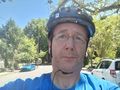
Me, looking dumb at the hashpoint
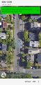
Evidence
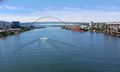
View north up the Willamette River, from later in the ride
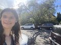
Gaelan's Grin(TM), unfortunately a day early
Gaelan's evidence


Achievements
- Land Geohash
- Bike Geohash
Gaelan earned the Blinded by Science Consolation Prize
|