Difference between revisions of "2011-04-09 52 1"
imported>Sourcerer m (→Location) |
imported>Sourcerer |
||
| Line 1: | Line 1: | ||
| − | |||
| − | |||
| − | |||
| − | |||
{{meetup graticule | {{meetup graticule | ||
| lat=52 | | lat=52 | ||
| Line 8: | Line 4: | ||
| date=2011-04-09 | | date=2011-04-09 | ||
| graticule_name=Norwich | | graticule_name=Norwich | ||
| − | | graticule_link=Norwich, United Kingdom}} | + | | graticule_link=Norwich, United Kingdom |
| + | }} | ||
| + | |||
| + | == Location == | ||
| + | |||
| + | A few metres off the A140 in a road-repair gravel dump between Brome and Yaxley a few miles south of Diss, Norfolk, UK. | ||
== Participants == | == Participants == | ||
| Line 20: | Line 21: | ||
== Photo Gallery == | == Photo Gallery == | ||
| − | <gallery | + | <gallery> |
Image:2011-04-09_52_1_Sourcerer_1.jpg|View from Garmin Mapsource | Image:2011-04-09_52_1_Sourcerer_1.jpg|View from Garmin Mapsource | ||
</gallery> | </gallery> | ||
| Line 28: | Line 29: | ||
{{expedition summaries|2011-04-09}} | {{expedition summaries|2011-04-09}} | ||
| + | [[Category:Expeditions]] | ||
[[Category:Expeditions with photos]] | [[Category:Expeditions with photos]] | ||
[[Category:Coordinates reached]] | [[Category:Coordinates reached]] | ||
| − | |||
| − | |||
Revision as of 15:25, 22 August 2012
| Sat 9 Apr 2011 in Norwich: 52.3338518, 1.1192604 geohashing.info google osm bing/os kml crox |
Contents
Location
A few metres off the A140 in a road-repair gravel dump between Brome and Yaxley a few miles south of Diss, Norfolk, UK.
Participants
Expedition
Neil found the hashpoint easily enough diverting less than five miles on yet another trip to France. Looking at Google Earth, there was clearly a mystery "feature" at the hashpoint. On arrival, it turned out to be piles of gravel for road surfacing and other piles of mixed stuff stripped off other roads prior to resurfacing. There was a short gated access road where it was possible to park. The gate prevented vehicular access but it was simple enough to walk round the end of it. There was no work going on and there were no no-entry signs. The hashpoint was only a few metres away. It was an absolutely wonderful sunny spring morning, ideal for viewing gravel piles. But that is the joy of geohashing. You never know what you might find.
Photo Gallery
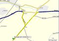
View from Garmin Mapsource

Other Geohashing Expeditions and Plans on This Day
Expeditions and Plans
| 2011-04-09 | ||
|---|---|---|
| Palm Beach, Florida | Dtobias | In the woods between some houses and the railroad tracks near I-95 in Boca ... |
| Casa Grande, Arizona | Wyle, RoadRunner, Wyle & RoadRunner | near the end of a cul-de-sac by Ina/Wade |
| Fort Collins, Colorado | Someone went | Between Lonetree Reservoir and Welch Reservoir. Appears to be near a trai... |
| Boston, Massachusetts | Shishire, Phyzome | in parking lot behind a store in the middle of Brookline. It's right on MB... |
| Vancouver, British Columbia | Wade, Robyn | An accessible forested area in West Vancouver. It's just west of the Capila... |
| Regensburg, Germany | dawidi | In a forest on a hill next to Schwandorf. |
| Norwich, United Kingdom | Sourcerer | A few metres off the A140 in a road-repair gravel dump between Brome and Ya... |
| Rheine, Germany | Arvid | Tracklog by bicycle Only about 25km from home, at the other side of the ... |