imported>Tongs |
m (Renaming 36,-5 Algeciras, Spain) |
||
| Line 61: | Line 61: | ||
=== Map === | === Map === | ||
| − | Visited graticules are shown in pale green. This was stolen from the [[United Kingdom]] page. [[ | + | Visited graticules are shown in pale green. This was stolen from the [[United Kingdom]] page. [[Algeciras, Spain]] is not shown. |
{|cellpadding=4 | {|cellpadding=4 | ||
Latest revision as of 20:03, 17 January 2021
This is page is probably out of date.
Contents
Counting things
- Distinct graticules: 5.
- Total hashpoints bagged: 18.
- The Tongs are at Level 4. Hashpoints until we level up to Level 5: 15.
- Saturday meetups we've made: 4.
- People we've ever met doing geohashing: Benjw, Chrome Crusaders, Sourcerer, Saxbophone.
Reverse regional achievement in (52, 0)
Assuming this is at the county level, we need to have visited six counties, of which Lincolnshire is the trickiest.
| County | First expedition |
|---|---|
| Cambridgeshire | 2014-08-17 |
| Essex | 2016-05-21 |
| Hertfordshire | 2014-08-23 |
| Lincolnshire | - |
| Norfolk | 2015-08-30 |
| Suffolk | - |
Simultaneous doublehash in (52, 0) and (52, -0)
About once every 25 years, it becomes possible to be in the uncertainty circle of both hashpoints simultaneously if the longitude is less than +/- 0.000100°. For now, we track the closest distance between two hashpoints.
| Date | First | Second | Distance |
|---|---|---|---|
| 2014-08-23 | 52, 0 | 52, -0 | 8022m |
| 2016-03-12 | 52, -0 | 52, 0 | 3492m |
Map
Visited graticules are shown in pale green. This was stolen from the United Kingdom page. Algeciras, Spain is not shown.
| -8 | -7 | -6 | -5 | -4 | -3 | -2 | -1 | -0 | +0 | +1 | |
|---|---|---|---|---|---|---|---|---|---|---|---|
| 60 | 60,-2 | 60,-1 | 60,-0 | ||||||||
| 59 | 59,-3 | 59,-2 | 59,-1 | ||||||||
| 58 | 58,-7 | 58,-6 | 58,-5 | 58,-4 | 58,-3 | 58,-2 | |||||
| 57 | 57,-8 | 57,-7 | 57,-6 | 57,-5 | 57,-4 | 57,-3 | 57,-2 | 57,-1 | |||
| 56 | 56,-7 | 56,-6 | 56,-5 | 56,-4 | 56,-3 | 56,-2 | |||||
| 55 | 55,-7 | 55,-6 | 55,-5 | 55,-4 | 55,-3 | 55,-2 | 55,-1 | ||||
| 54 | 54,-8 | 54,-7 | 54,-6 | 54,-5 | 54,-4 | 54,-3 | 54,-2 | 54,-1 | 54,-0 | ||
| 53 | 53,-4 | 53,-3 | 53,-2 | 53,-1 | 53,-0 | 53,0 | |||||
| 52 | 52,-5 | 52,-4 | 52,-3 | 52,-2 | 52,-1 | 52,-0 | 52,0 | 52,1 | |||
| 51 | 51,-5 | 51,-4 | 51,-3 | 51,-2 | 51,-1 | 51,-0 | 51,0 | 51,1 | |||
| 50 | 50,-5 | 50,-4 | 50,-3 | 50,-2 | 50,-1 | 50,-0 | 50,0 | ||||
| 49 | 49,-6 | 49,-5 | 49,-2 | ||||||||
Another map
It would be very silly to do a best fit line on this map, so I plan to do that at some point.
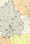
This map shows the points we've visited, up to point 14. The opacity of each circle is proportional to the number of Tongs who visited the hashpoint that day. Grid squares are 0.1 degrees. You can see the counties we've visited - Cambridgeshire is in grey, and Norfolk to the northeast and Hertfordshire to the south in orange, and Essex to the southeast in yellow.
Achievements unlocked
This user earned the Land geohash achievement
|
This user earned the Multihash Achievement
|
This user earned the Multihash Achievement
|
