2009-05-08 49 -120
| Fri 8 May 2009 in 49,-120: 49.3822991, -120.1317194 geohashing.info google osm bing/os kml crox |
People met here. Played Twister. Saw deer. Write up later.
Contents
Location
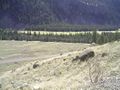
Up a hill, across Highway 3 (Crowsnest), 1.3 km from Stemwinder Provincial Park campsite, east of Princeton.
Participants
Planning
Robyn and Rhonda have been meeting each other at or on the way to geohashes ever since Rhonda joined the sport, and Vancouver is such an active graticule that the two have each met a number of geohashers. Meanwhile Juventas has been geohashing since July 2008 but due to the sparse population and remote locations in his graticule, has never met another geohasher. He posts spectacular photographs of rugged scenery, and eye-opening accounts of his attempts to reach remote locations, so clearly he was up for a challenge. In the interest of geohasher camaraderie and increasing connectivity on the Meetup Graph it was time for a road trip.
We started planning this trip a few weeks ago. We decided that it would involve overnight camping, ideally to earn the at-that-time-unclaimed Camping geohash achievement. While we were still negotiating a mutually free weekend, an ideal camping geohash came up in Bellingham and Robyn and Rhonda went and did it, but Juventas still needed the achievement for his portfolio, plus Robyn and Robyn needed more practice camping. We settled on May 9th/10th, but it's very difficult to make detailed advance plans for a geohash, as we wouldn't know where it was until the weekend arrived. Juventas lives 450 km away from Robyn and Rhonda, with six different graticules on the road in between, so we decided that when the weekend coordinates came out on Friday morning we would discuss them and choose the best one(s) in between in which to meet. There were no known geohashers in the intervening graticules.
Coordinates are announced on Friday at 6:30 a.m. Pacific time, so we woke then and started searching for points that were accessible and possibly appropriate for camping. Juventas had maps and local knowledge of the graticules closer to him, so Robyn and Rhonda concentrated on the graticules closer to them. Princeton looked achievable on the Friday, and Juventas said that Kelowna was doable, so Robyn and Rhonda decided to go to Princeton on the way to the Kelowna area. Then Juventas, who had taken Friday off, said he would meet the women there. We arranged a rendezvous at Stemwinder Provincial Park, and started the road trip.
Expedition
Robyn
My purist vision of geohashing would have us specify no other meeting place than the geohash itself. I have this sustained image of people from different places climbing up different faces of the same mountain and slowly converging on the same otherwise undistinguished point. But romantic notions take second place to safety, and it's a much better idea to meet at the base of the mountain and all climb it together. That way no one gets eaten by a bear, or falls down and is never found again, except maybe by a bear.
I packed the car with a small inflatable boat, some rope, a lifejacket, a tent, two sleeping bags, a couple of knapsacks of different sizes, a stove, fuel, a warm jacket, raingear, a couple of changes of clothes, GPS, compass, chalk, and a Twister game. I added my trusty hashscot T-Rex to the pile and drove to North Vancouver to pick up Rhonda.
Rhonda
After finding out that the Friday and Saturday co-ordinates for all the graticules and days we were interested in were relatively close to highways (or at least logging roads), I packed my usual camping gear, ran around in circles trying to find everything that I had forgotten to pack on the previous camping trip, included all remaining apples and bananas from my counter in my packing, and carried it all out the front door to wait for Robyn.
The drive
Rhonda was at the curb and her backpack fit into the car with T-Rex and Robyn's gear, so they were soon underway together. Friday morning traffic was light and there were no delays getting onto the trans-Canada highway or out of the city. Rhonda texted Juventas with an eta of about 1:30 p.m. Robyn's little car hummed along over the Port Mann Bridge and past sites of earlier geohashes, reaching them disorientingly quickly compared to our usual bicycle or transit transportation. Within an hour we were beyond our previous most distant geohash and the mountains began to close in on the highway.
After the town of Hope the trans-Canada highway heads north to Lytton and Cache Creek before turning east to fulfill its name; we didn't want that, but nor could we take the new six-lane Coquihalla Highway at 110 km/h straight to the interior. To get to Princeton we had to take the exit leading to the old Crowsnest highway. It has a reputation as a treacherous road, because it clings to the cliff on the north with a sheer drop to the Similkameen River on the south. There is almost no room for a shoulder, and there have been a number of bad accidents here over the years. But the highway has had some improvements, and on a clear day like this one with light traffic it was a fun drive. We went south through Manning Park (and took a break there at a rest stop with an outhouse) then turned north and exited the park through Alison Pass. We drove past Copper Mountain (where everything is named after the mountain), through Princeton (which the graticule is named after), and found Stemwinder Provincial Park.
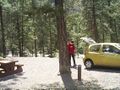
It's a little gem of a park tucked into a widening of the space between the highway and the fast-flowing Similkameen River. The best campsites are on the lower road, closer to the river and further from the highway. There was almost no one in the campground, so we parked in campsite #1, closest to the road, and sorted out which gear we to take to the geohash, while we waited for Juventas. Rhonda's cellphone started to beep with messages. There was no cell service on the highway between Hope and Princeton so texts from Juventas had been waiting in the system to catch up. One message says he'll be here at two. Another one amends that, saying he's stuck in construction. Rhonda and Robyn didn't know if he was getting any of their messages, because cellphones just don't work in BC outside the cities. There are too many mountains.
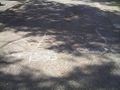
At 3:30 p.m. Rhonda and Robyn realized that if anyone is going to reach that geohash, they had better start soon, so they chalked a message to Juventas on the pavement, and set off on foot towards the geohash.
Juventas
Hiking up
Success
Hiking down
On to the next hash point.
Photos
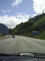
Starting our trip on highway 1 (trans-canada)
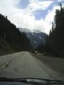
Continuing along highway 3 (crowsnest)
The closest legal parking spot...
Not waiting any longer
The first part was easy
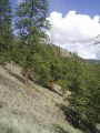
the next part a little less so
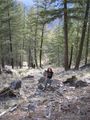
Rhonda walking up the slope to the geohash
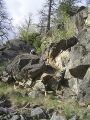
Sometimes it wasn't really a slope
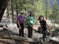
Robyn, Juventas and Rhonda at the geohash
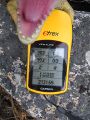
T-Rex shows proof of our arrival
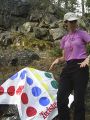
Twister, anyone?
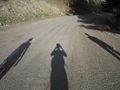
Our shadows precede us down the access road


