Difference between revisions of "2013-04-28 47 11"
imported>Jiml m (Adjust to indicate planning status) |
imported>FippeBot m (Location) |
||
| (39 intermediate revisions by 2 users not shown) | |||
| Line 1: | Line 1: | ||
| − | + | {{Advert}} | |
| − | + | [[Image:{{{image|2013-04-28 47 11 15-24-31-412.jpg}}}|thumb|left]] | |
| − | |||
| − | [[Image:{{{image| | ||
| − | |||
| − | |||
| − | |||
| − | |||
| − | |||
| − | |||
{{meetup graticule | {{meetup graticule | ||
| lat=47 | | lat=47 | ||
| Line 18: | Line 10: | ||
__NOTOC__ | __NOTOC__ | ||
== Location == | == Location == | ||
| − | + | On a meadow in the middle of the village Thaur, opposite to the priest's office. | |
== Participants == | == Participants == | ||
<!-- who attended: If you link to your wiki user name in this section, your expedition will be picked up by the various statistics generated for geohashing. You may use three tildes ~ as a shortcut to automatically insert the user signature of the account you are editing with. | <!-- who attended: If you link to your wiki user name in this section, your expedition will be picked up by the various statistics generated for geohashing. You may use three tildes ~ as a shortcut to automatically insert the user signature of the account you are editing with. | ||
--> | --> | ||
| − | * [[User:LeslieHapablap|LeslieHapablap]] | + | * [[User:LeslieHapablap|LeslieHapablap]], (previous|[[2013-05-01_47_11|next]]) |
| − | * | + | * [[User:EleanorAbernathy|EleanorAbernathy]] |
| + | * [[User:LeslieHapablap/Waltraud|Waltraud]] the hashkiwi | ||
| + | on our very first hash. | ||
== Plans == | == Plans == | ||
| Line 30: | Line 24: | ||
We plan to go there by bike from Innsbruck, reaching the hash point at about 2pm. We will continue to Hall and then back to Innsbruck along the Inn. | We plan to go there by bike from Innsbruck, reaching the hash point at about 2pm. We will continue to Hall and then back to Innsbruck along the Inn. | ||
| − | The hash point should not be too hard to reach, except if it is private ground | + | The hash point should not be too hard to reach, except if it is private ground fiercely defended by locals. |
== Expedition == | == Expedition == | ||
<!-- how it all turned out. your narrative goes here. --> | <!-- how it all turned out. your narrative goes here. --> | ||
| + | |||
| + | |||
| + | *Here we go... beautiful day! -- [[User:LeslieHapablap|LeslieHapablap]] ([[User talk:LeslieHapablap|talk]]) 13:26, 28 April 2013 (CET) | ||
| + | |||
| + | *We reached the coordinates. This was way too easy, but a nice first hash. -- [[User:LeslieHapablap|LeslieHapablap]] ([[User talk:LeslieHapablap|talk]]) [http://www.openstreetmap.org/?lat=47.29585370&lon=11.47167444&zoom=16&layers=B000FTF @47.2959,11.4717] 14:04, 28 April 2013 (CET) | ||
| + | |||
| + | This hash was located just a few hundred meters off one of our usual biking routes. What looked like a field on the sattelite image turned out to be a meadow, so we didn't have to worry about trampling down crop or something. The hashpoint was perfectly accessible, and our marker really has a very good chance to be seen by other people. | ||
| + | |||
| + | The expedition was pretty uneventful, but fun nevertheless. On our way back we made a small detour to find a hashcat, and we did! | ||
== Tracklog == | == Tracklog == | ||
| − | + | [http://goo.gl/maps/wJL40 Our track.] This does not pass through the hashpoint because it was recorded with a second gps device attached to the bike. | |
== Photos == | == Photos == | ||
| Line 43: | Line 46: | ||
--> | --> | ||
<gallery perrow="5"> | <gallery perrow="5"> | ||
| + | |||
| + | Image:2013-04-28_47_11_15-12-02-657.jpg | Our newly declared hashcot Waltraud learning about geohashing. | ||
| + | |||
| + | Image:2013-04-28_47_11_15-24-31-412.jpg | Nice location for a geohash. | ||
| + | |||
| + | Image:2013-04-28_47_11_15-33-15-613.jpg | Obligatory proof we were there. | ||
| + | |||
| + | Image:2013-04-28_47_11_15-48-15-942.jpg | Obligatory stupid grin. | ||
| + | |||
| + | Image:2013-04-28_47_11_15-50-49-929.jpg | Another one with hashcot. | ||
| + | |||
| + | Image:2013-04-28_47_11_15-53-47-736.jpg | We left a [[User:Crox/Poster|marker]] (thx to Crox for this tool). | ||
| + | |||
| + | Image:2013-04-28_47_11_15-58-12-895.jpg | You're a [http://xkcd.com/231/ hashcat]! | ||
</gallery> | </gallery> | ||
| + | |||
| + | == Other geohashing expeditions on the same day == | ||
| + | |||
| + | {{expedition summaries|2013-04-28}} | ||
== Achievements == | == Achievements == | ||
{{#vardefine:ribbonwidth|800px}} | {{#vardefine:ribbonwidth|800px}} | ||
<!-- Add any achievement ribbons you earned below, or remove this section --> | <!-- Add any achievement ribbons you earned below, or remove this section --> | ||
| + | {{land geohash | ||
| + | |||
| + | | latitude = 47 | ||
| + | | longitude = 11 | ||
| + | | date = 2013-04-28 | ||
| + | | name = [[User:LeslieHapablap|LeslieHapablap]] and [[User:EleanorAbernathy|EleanorAbernathy]] | ||
| + | |||
| + | }} | ||
| + | {{bicycle geohash | ||
| + | |||
| + | | latitude = 47 | ||
| + | | longitude = 11 | ||
| + | | date = 2013-04-28 | ||
| + | | name = [[User:LeslieHapablap|LeslieHapablap]] and [[User:EleanorAbernathy|EleanorAbernathy]] | ||
| + | | distance = 28.4 km | ||
| + | | bothways = true | ||
| + | }} | ||
| + | {{Hashcat | ||
| − | + | | latitude = 47 | |
| − | + | | longitude = 11 | |
| − | [[ | + | | date = 2013-04-28 |
| + | | name = [[User:LeslieHapablap|LeslieHapablap]] and [[User:EleanorAbernathy|EleanorAbernathy]] | ||
| + | | image = 2013-04-28 47 11 15-58-12-895.jpg | ||
| + | }} | ||
| + | {{Two to the N achievement | ||
| − | + | | latitude = 47 | |
| + | | longitude = 11 | ||
| + | | date = 2013-04-28 | ||
| + | | name = [[User:LeslieHapablap|LeslieHapablap]] and [[User:EleanorAbernathy|EleanorAbernathy]] | ||
| + | | count=0 | ||
| + | | reached=True | ||
| + | }} | ||
| − | |||
| − | |||
[[Category:Expeditions]] | [[Category:Expeditions]] | ||
| − | |||
[[Category:Expeditions with photos]] | [[Category:Expeditions with photos]] | ||
| − | |||
| − | |||
| − | |||
| − | |||
| − | |||
[[Category:Coordinates reached]] | [[Category:Coordinates reached]] | ||
| − | + | {{location|AT|T|IL}} | |
| − | |||
| − | |||
| − | |||
| − | |||
| − | |||
| − | |||
| − | |||
| − | |||
| − | |||
| − | |||
| − | |||
| − | |||
| − | |||
| − | |||
| − | |||
| − | |||
| − | |||
Latest revision as of 02:04, 14 August 2019
| Have you seen our geohashing marker? We'd love to hear from you! Click here to say "hi" and tell us what you've seen!
Curious about what geohashing is? Read more! |

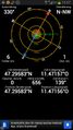
| Sun 28 Apr 2013 in 47,11: 47.2958254, 11.4715725 geohashing.info google osm bing/os kml crox |
Location
On a meadow in the middle of the village Thaur, opposite to the priest's office.
Participants
- LeslieHapablap, (previous|next)
- EleanorAbernathy
- Waltraud the hashkiwi
on our very first hash.
Plans
We plan to go there by bike from Innsbruck, reaching the hash point at about 2pm. We will continue to Hall and then back to Innsbruck along the Inn.
The hash point should not be too hard to reach, except if it is private ground fiercely defended by locals.
Expedition
- Here we go... beautiful day! -- LeslieHapablap (talk) 13:26, 28 April 2013 (CET)
- We reached the coordinates. This was way too easy, but a nice first hash. -- LeslieHapablap (talk) @47.2959,11.4717 14:04, 28 April 2013 (CET)
This hash was located just a few hundred meters off one of our usual biking routes. What looked like a field on the sattelite image turned out to be a meadow, so we didn't have to worry about trampling down crop or something. The hashpoint was perfectly accessible, and our marker really has a very good chance to be seen by other people.
The expedition was pretty uneventful, but fun nevertheless. On our way back we made a small detour to find a hashcat, and we did!
Tracklog
Our track. This does not pass through the hashpoint because it was recorded with a second gps device attached to the bike.
Photos

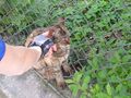
Our newly declared hashcot Waltraud learning about geohashing.
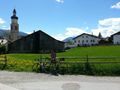
Nice location for a geohash.
Obligatory proof we were there.

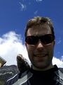
Obligatory stupid grin.
Another one with hashcot.
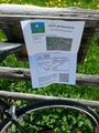
We left a marker (thx to Crox for this tool).
You're a hashcat!


Other geohashing expeditions on the same day
Expeditions and Plans
| 2013-04-28 | ||
|---|---|---|
| Ballarat, Australia | Snaplatitude, a McDonalds Employee | A private paddock in Lexton |
| Springfield, Massachusetts | Todd | A quarter mile into a forest off Harris St/Harris Mountain Rd in Granby nea... |
| Houghton, Michigan | Someone went | On the Keweenaw peninsula. |
| Innsbruck, Austria | LeslieHapablap, EleanorAbernathy, Waltraud | On a meadow in the middle of the village Thaur, opposite to the priest's of... |
| Frankfurt am Main, Germany | QuarterCacher, LadyBB, EmmJay, Mampfred | On a little strip of grass near Schmitten. Better known as "in the pampa". |
| London West, United Kingdom | KennethCC | A muddied rut at the side of a narrow country lane outside Ockham in Surrey... |
| Leipzig, Germany | Bazaruto | Small wood near Holzhausen. |
| Eindhoven, Netherlands | Wythnir | In the bushes next to a small road near Schaft. |
| Birmingham, United Kingdom | Bollerenshaws | In a farmer's field north-east of Offchurch near Leamington Spa, UK. |
| Norwich, United Kingdom | Sourcerer | 500 metres east of the water tower near Sibton Green, Suffolk, UK. |
| Amsterdam, Netherlands | Murfie, Palmpje | Langevelderslag, The Netherlands |
| Karlskoga, Sweden | the ru, Thomas | In a forest just outside Karlskoga. |
Achievements
LeslieHapablap and EleanorAbernathy earned the Land geohash achievement
|
LeslieHapablap and EleanorAbernathy earned the Bicycle geohash achievement
|
LeslieHapablap and EleanorAbernathy earned the Hashcat achievement
|
