Difference between revisions of "2015-09-21 52 0"
From Geohashing
imported>Sourcerer m ([retro] Arrived.) |
imported>Sourcerer m ([retro picture] Proof. [http://www.openstreetmap.org/?lat=52.95819998&lon=.67172706&zoom=16&layers=B000FTF @52.9582,.6717]) |
||
| Line 27: | Line 27: | ||
<gallery perrow="5"> | <gallery perrow="5"> | ||
| + | |||
| + | Image:2015-09-21_52_0_Sourcerer_1442789993284.jpg | Proof. [http://www.openstreetmap.org/?lat=52.95819998&lon=.67172706&zoom=16&layers=B000FTF @52.9582,.6717] | ||
</gallery> | </gallery> | ||
Revision as of 23:01, 20 September 2015
| Mon 21 Sep 2015 in 52,0: 52.9581858, 0.6717740 geohashing.info google osm bing/os kml crox |
Location
A field perimeter south of Brancaster Staithe, Norfolk, UK.
Participants
Plans
Expedition two of two spanning midnight - 2015-09-20 52 0 - 2015-09-21 52 0 - ETA 00:00.
Expedition
This is less than 400 metres west of 2015-08-09 52 0.
- Arrived. -- Sourcerer (talk) @52.9582,.6717 00:00, 21 September 2015 (GMT+01:00)
Photos
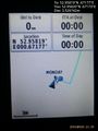
Proof. @52.9582,.6717

Achievements
Expeditions and Plans
| 2015-09-21 | ||
|---|---|---|
| Erfurt, Germany | Juja, Davey | In a forest near Beutnitz, Thuringia, about 400m from a very recent Geohash... |
| Bristol, United Kingdom | Benjw | An unused paddock behind a house between Hereford and Ross-on-Wye. |
| Cambridge, United Kingdom | Sourcerer | A field perimeter south of Brancaster Staithe, Norfolk, UK. |
| Kuopio, Finland | Pastori, The Wife | Kuopio, Sorsasalo. The point lies next to Kallansillat (bridges over Lake K... |
Sourcerer's Expedition Links
2015-09-20 52 0 - 2015-09-21 52 0 - 2015-09-22 52 1 - KML file download of Sourcerer's expeditions for use with Google Earth.