Difference between revisions of "2019-06-05 45 -120"
imported>Michael5000 (Created page with "{{subst:Expedition |lat = 45 |lon = -120 |date = 2019-06-05 }}") |
Michael5000 (talk | contribs) (→Location) |
||
| (6 intermediate revisions by 2 users not shown) | |||
| Line 19: | Line 19: | ||
== Location == | == Location == | ||
| − | + | ||
| + | On the shoulder of Berthold Road, five or six miles south of the Columbia and just south of the big waste facility in Gilliam County. | ||
== Participants == | == Participants == | ||
| − | |||
| − | |||
| − | + | *[[User:Michael5000|Michael5000]] | |
| − | |||
== Expedition == | == Expedition == | ||
| − | |||
| − | + | After stopping for the hashpoint at [[2019-06-05 45 -121]], I continued my drive eastward though the Columbia Gorge as far as the little town of Arlington, and then drove southward up from the river. The hashpoint is near the railyard where all of the garbage from Portland, where I live, is brought to be hauled up into a huge landfill up on the ridge. I thought it might be kind of stinky, but it was nice and quiet, a very rural scene. I wandered around for a while and took some pictures. Then, I figured it was about time to be starting for home! | |
| − | |||
== Photos == | == Photos == | ||
| − | |||
| − | |||
| − | |||
<gallery perrow="5"> | <gallery perrow="5"> | ||
| + | File:2019-06-05 45 -120 car.jpg|This expedition involved a lot of driving, and not a lot of much else. | ||
| + | File:2019-06-05 45 -120 garbage train.jpg|A lovely valley graced by a garbage train. | ||
| + | File:2019-06-05 45 -120 bear.jpg|The bear enjoyed the chance to go for a long drive. | ||
| + | File:2019-06-05 45 -120 me.jpg|And so did I. | ||
</gallery> | </gallery> | ||
== Achievements == | == Achievements == | ||
{{#vardefine:ribbonwidth|800px}} | {{#vardefine:ribbonwidth|800px}} | ||
| − | |||
| − | < | + | <gallery perrow="5"> |
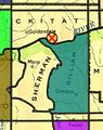
| − | + | File:2019-06-05 45 -120 county map.jpg|I finally claimed Gilliam County, the 29th of Oregon's 36 counties. | |
| − | + | File:2019-06-05 45 -120 stained glass map.jpg|And, this was my first success in the Goldendale graticule. | |
| + | </gallery> | ||
| − | + | *This was the first success by anyone on the [[Oregon]] side of the [[Goldendale, Washington|Goldendale]] graticule. | |
| + | |||
| − | + | {{Multihash2 | |
| − | |||
| − | |||
| − | |||
| − | + | | date = 2019-06-05 | |
| + | | count = 2 | ||
| + | | name = [[user:michael5000|Michael5000]] | ||
| − | + | }} | |
| − | [[ | + | |
| − | + | {{Minesweeper geohash | |
| − | [[ | + | | graticule = [[The Dalles, Oregon]] |
| − | [[ | + | | ranknumber = 7 |
| − | + | | n = true | |
| − | + | | e = true | |
| − | + | | se = true | |
| − | + | | s = true | |
| − | + | | sw = true | |
| − | + | | w = true | |
| − | [[ | + | | nw = true |
| + | | name = [[User:Michael5000|Michael5000]] | ||
| + | }} | ||
| + | |||
| + | {{Minesweeper geohash | ||
| + | | graticule = [[Bend, Oregon]] | ||
| + | | ranknumber = 7 | ||
| + | | n = true | ||
| + | | ne = true | ||
| + | | s = true | ||
| + | | se = true | ||
| + | | e = true | ||
| + | | nw = true | ||
| + | | w = true | ||
| + | | name = [[User:Michael5000|Michael5000]] | ||
| + | }} | ||
| + | {{Minesweeper geohash | ||
| + | | graticule = [[Prineville, Oregon]] | ||
| + | | ranknumber = 6 | ||
| + | | nw = true | ||
| + | | n = true | ||
| + | | ne = true | ||
| + | | w = true | ||
| + | | sw = true | ||
| + | | s = true | ||
| + | | name = [[User:Michael5000|Michael5000]] | ||
| + | }} | ||
| − | + | {{Minesweeper geohash | |
| − | [[ | + | | graticule = [[Mt. Rainier, Washington]] |
| − | + | | ranknumber = 6 | |
| − | + | | n = true | |
| − | + | | se = true | |
| − | + | | s = true | |
| − | + | | sw = true | |
| − | [[ | + | | w = true |
| + | | nw = true | ||
| + | | name = [[User:Michael5000|Michael5000]] | ||
| + | }} | ||
| − | + | {{Minesweeper geohash | |
| − | [[ | + | | graticule = [[Goldendale, Washington]] |
| − | + | | ranknumber = 5 | |
| − | + | | e = true | |
| − | [[ | + | | s = true |
| + | | sw = true | ||
| + | | w = true | ||
| + | | nw = true | ||
| + | | name = [[User:Michael5000|Michael5000]] | ||
| + | }} | ||
| − | + | [[Category:Expeditions]] | |
| + | [[Category:Expeditions with photos]] | ||
| + | [[Category:Coordinates reached]] | ||
| + | {{location|US|OR|GI}} | ||
Latest revision as of 16:45, 10 February 2022
| Wed 5 Jun 2019 in 45,-120: 45.6097674, -120.2047254 geohashing.info google osm bing/os kml crox |
Location
On the shoulder of Berthold Road, five or six miles south of the Columbia and just south of the big waste facility in Gilliam County.
Participants
Expedition
After stopping for the hashpoint at 2019-06-05 45 -121, I continued my drive eastward though the Columbia Gorge as far as the little town of Arlington, and then drove southward up from the river. The hashpoint is near the railyard where all of the garbage from Portland, where I live, is brought to be hauled up into a huge landfill up on the ridge. I thought it might be kind of stinky, but it was nice and quiet, a very rural scene. I wandered around for a while and took some pictures. Then, I figured it was about time to be starting for home!
Photos
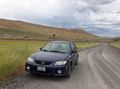
This expedition involved a lot of driving, and not a lot of much else.
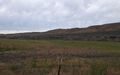
A lovely valley graced by a garbage train.
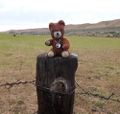
The bear enjoyed the chance to go for a long drive.

And so did I.


Achievements
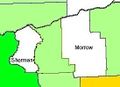
I finally claimed Gilliam County, the 29th of Oregon's 36 counties.
And, this was my first success in the Goldendale graticule.


- This was the first success by anyone on the Oregon side of the Goldendale graticule.
Michael5000 earned the Multihash Achievement
|
Michael5000 achieved level 7 of the Minesweeper Geohash achievement
|
Michael5000 achieved level 7 of the Minesweeper Geohash achievement
|
Michael5000 achieved level 6 of the Minesweeper Geohash achievement
|
Michael5000 achieved level 6 of the Minesweeper Geohash achievement
|
Michael5000 achieved level 5 of the Minesweeper Geohash achievement
|