imported>Sourcerer |
|
| (86 intermediate revisions by 4 users not shown) |
| Line 1: |
Line 1: |
| − | {{#vardefine:ribbonwidth|800px}}{{Sourcerer_Nav}} [http://xkcd.nathanwoodruff.com/GooMapXKCDSourcerer.htm Interactive Map] implemented by [[User:NWoodruff|NWoodruff]]. | + | {{#vardefine:ribbonwidth|800px}} |
| | __NOTOC__ | | __NOTOC__ |
| | {| style="text-align:center;" | | | {| style="text-align:center;" | |
| Line 5: |
Line 5: |
| | | __TOC__ | | | __TOC__ |
| | | [[Image:nb_in_52_1.jpg|286px]] | | | [[Image:nb_in_52_1.jpg|286px]] |
| − | {{ASG|Y=1953|m=10|d=17|gender=m|lat=52|lon=1|float=none}} | + | {{ASG|Y=1953|m=10|d=17|gender=M|lat=52|lon=1|float=none}} |
| | | | | | |
| | {{User Suffolk|float=none}} | | {{User Suffolk|float=none}} |
| Line 31: |
Line 31: |
| | == Calculators and Links == | | == Calculators and Links == |
| | | | |
| − | '''Calculators: ''' [http://nbest.co.uk/kmlGeohash/testForm.php Sourcerer's KML Tool] - [http://geohashing.info/?lat=52.458526&lon=1.435400&&glat=52&glon=0&date=today Eupeodes] - [http://carabiner.peeron.com/xkcd/map/map.html Peeron] - [http://tjum.anthill.de/cgi-bin/geohash.cgi?lat=52.4586&lon=1.43547&nr=o&map=gs&size=240x240&t=&date=&unit=km Ekorren's Tool] - [https://play.google.com/store/apps/details?id=net.exclaimindustries.geohashdroid&hl=en Geohash Droid (Android)] - [http://stattrek.com/online-calculator/binomial.aspx Probabilities] | + | '''Calculators: ''' [https://nbest.co.uk/kmlGeohash/testForm.php Sourcerer's KML Tool] - [http://geohashing.info/?lat=52.458526&lon=1.435400&&glat=52&glon=0&date=today Eupeodes] - [http://carabiner.peeron.com/xkcd/map/map.html Peeron] - [http://tjum.anthill.de/cgi-bin/geohash.cgi?lat=52.4586&lon=1.43547&nr=o&map=gs&size=240x240&t=&date=&unit=km Ekorren's Tool] - [https://play.google.com/store/apps/details?id=net.exclaimindustries.geohashdroid&hl=en Geohash Droid (Android)] - [http://stattrek.com/online-calculator/binomial.aspx Probabilities] |
| | | | |
| − | '''Links: ''' [http://wiki.xkcd.com/geohashing/United_Kingdom UK Graticules] - [https://cbe002.chat.mibbit.com/?server=irc.foonetic.net&channel=%23geohashing&nick=Sourcerer Foonetic] - [[Most_active_graticules | Graticule Stats]] - [[Most_active_users | User Stats]] - [[Maps_and_statistics|Maps and statistics]] - [http://wiki.xkcd.com/wgh/index.php?title=Special%3AListFiles&limit=50&ilsearch=&user=Sourcerer My Images] - [[Sourcerer Implementation Notes|Implementation Notes]] - [http://www.timeanddate.com/moon/uk/norwich Moonrise and set] | + | '''Links: ''' [[United Kingdom|UK Graticules]] - [https://cbe002.chat.mibbit.com/?server=irc.foonetic.net&channel=%23geohashing&nick=Sourcerer Foonetic] - [[Most_active_graticules | Graticule Stats]] - [[Most_active_Geohashers | Geohasher Stats]] - [[Maps_and_statistics|Maps and statistics]] - [{{canonicalurl:Special:ListFiles|limit=50&ilsearch=&user=Sourcerer}} My Images] - [[Sourcerer Implementation Notes|Implementation Notes]] - [http://www.timeanddate.com/moon/uk/norwich Moonrise and set] |
| | | | |
| | == Hash Map == | | == Hash Map == |
| | | | |
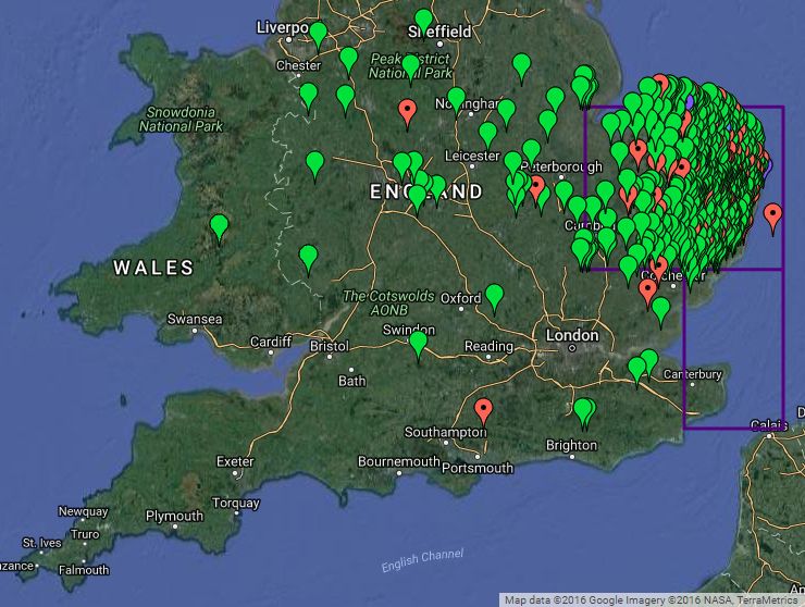
| − | * There is a more up-to-date [http://nbest.co.uk/SourcererGeohash/index.php interactive version] using the Google Maps API. | + | * There is a more up-to-date [https://nbest.co.uk/SourcererGeohash/index.php interactive version] using the Google Maps API. |
| − | * Green=Reached, Red=Not reached, Purple=Never set out, Blue=Retro expedition. [http://nbest.co.uk/SourcererGeohash/SourcererGeohash.kml KML hashpoints download] | + | * Green=Reached, Red=Not reached, Purple=Never set out, Blue=Retro expedition. [https://nbest.co.uk/SourcererGeohash/SourcererGeohash.kml KML hashpoints download] |
| | + | |
| | + | [[File:Sourcerer Google Maps.jpg|link=https://nbest.co.uk/SourcererGeohash/index.php]] |
| | | | |
| − | [[File:Sourcerer Google Maps.jpg|link=http://nbest.co.uk/SourcererGeohash/index.php]]
| |
| | | | |
| | == Expeditions == | | == Expeditions == |
| | | | |
| − | The more interesting expeditions are highlighted by a yellow table row.
| + | {{Sourcerer_Nav}} Here is an [http://xkcd.nathanwoodruff.com/GooMapXKCDSourcerer.htm Interactive Map] implemented by [[User:NWoodruff|NWoodruff]]. |
| | | | |
| − | <!-- {{Sourcerer/Expedition | date = | lat = | lon = | day = | reaCount = | expCount = | reached = | text = }} --> | + | <!-- {{Sourcerer/Expedition | date = | lat = | lon = | day = | reaCount = | expCount = | reached = | text = }} --> |
| | {| cellpadding="2" border="1" cellspacing="0" | | {| cellpadding="2" border="1" cellspacing="0" |
| | |- | | |- |
| | | | | | |
| | + | ===January=== |
| | + | | '''Day''' || '''Map''' || '''Reached/Total''' || '''Summary''' - {{Planning|Planning}} {{Reached|Reached}} {{Fail|Not reached}} {{Retro|Retro}} || '''Achievements''' |
| | + | {{Sourcerer/Expedition | date = 2020-01-09 | lat = 33 | lon = -13 | day = Thu | reaCount = 564 | expCount = 644 | reached = yes | text = An ocean hashpoint about 340 km east of Funchal, Madeira, Atlantic Ocean. |
| | + | }} |
| | + | |} |
| | | | |
| − | ===December===
| + | |
| − | | '''Day''' || '''Map''' || '''Reached/Total''' || '''Summary''' - {{Planning|Planning}} {{Reached|Reached}} {{Fail|Not reached}} {{Retro|Retro}} || '''Achievements'''
| + | <!-- {{Sourcerer/Expedition | date = | lat = | lon = | day = | reaCount = | expCount = | reached = | text = }} --> |
| − | {{Sourcerer/Expedition | date = 2016-12-14 | lat = 52 | lon = 1 | day = Wed | reaCount = 503 | expCount = 576 | reached = yes | text = In a field north east of Ipswich, Suffolk, UK. }}
| + | {| cellpadding="2" border="1" cellspacing="0" |
| − | {{Sourcerer/Expedition | date = 2016-12-12 | lat = 52 | lon = 1 | day = Mon | reaCount = 502 | expCount = 575 | reached = yes | text = In a field in the South Elmhams, Suffolk, UK. }} | |
| − | {{Sourcerer/Expedition | date = 2016-12-11 | lat = 52 | lon = 1 | day = Sun | reaCount = 501 | expCount = 574 | reached = yes | text = Woodland in Dunwich Forest, Suffolk, UK. | achievements = Midnight }}
| |
| − | {{Sourcerer/Expedition | date = 2016-12-10 | lat = 52 | lon = 1 | day = Sat | reaCount = 500 | expCount = 573 | reached = yes | text = A field west of Theberton, Suffolk, UK. }}
| |
| − | {{Sourcerer/Expedition | date = 2016-12-05 | lat = 52 | lon = 1 | day = Mon | reaCount = 73 | expCount = 572 | reached = no | text = A field in Dunwich Forest near Potton Hall, Suffolk, UK. | achievements = MNB consolation }}
| |
| − | {{Sourcerer/Expedition | date = 2016-12-03 | lat = 52 | lon = 1 | day = Sat | reaCount = 21 | expCount = 21 | reached = retro | text = A residential street in Lowestoft, Suffolk, UK, reached a day late. | achievements = Kitty }} | |
| | |- | | |- |
| | | | | | |
| | | | |
| − | ===November=== | + | ===July=== |
| | | '''Day''' || '''Map''' || '''Reached/Total''' || '''Summary''' - {{Planning|Planning}} {{Reached|Reached}} {{Fail|Not reached}} {{Retro|Retro}} || '''Achievements''' | | | '''Day''' || '''Map''' || '''Reached/Total''' || '''Summary''' - {{Planning|Planning}} {{Reached|Reached}} {{Fail|Not reached}} {{Retro|Retro}} || '''Achievements''' |
| − | {{Sourcerer/Expedition | date = 2016-11-29 | lat = 52 | lon = 1 | day = Tue | reaCount = 499 | expCount = 571 | reached = yes | text = A field close to Somerleyton, Suffolk, UK. | achievements = Midnight | bgcolor = yellow }} | + | {{Sourcerer/Expedition | date = 2019-07-14 | lat = 52 | lon = 1 | day = Sun | reaCount = 563 | expCount = 644 | reached = yes | text = A residential street in north Norwich, Norfolk, UK. }} |
| − | {{Sourcerer/Expedition | date = 2016-11-28 | lat = 52 | lon = 1 | day = Mon | reaCount = 498 | expCount = 570 | reached = yes | text = A field east of Foulsham, Norfolk, UK. | achievements = Frozen }}
| |
| − | {{Sourcerer/Expedition | date = 2016-11-27 | lat = 52 | lon = 1 | day = Sun | reaCount = 497 | expCount = 569 | reached = yes | text = A field near Mettingham, Suffolk, UK 600 metres from a retro point. | achievements = Midnight, Walk, Tron }}
| |
| − | {{Sourcerer/Expedition | date = 2014-02-07 | lat = 52 | lon = 1 | day = Sat | reaCount = 20 | expCount = 20 | reached = retro | text = Across the road from the Tally Ho Tea Rooms, Mettingham, Suffolk, UK. }}
| |
| − | {{Sourcerer/Expedition | date = 2016-11-26 | lat = 52 | lon = 1 | day = Sat | reaCount = 496 | expCount = 568 | reached = yes | text = A field near Bustard's Green, Norfolk, UK 500 metres from a retro point. }}
| |
| − | {{Sourcerer/Expedition | date = 2015-09-11 | lat = 52 | lon = 1 | day = Sat | reaCount = 19 | expCount = 19 | reached = retro | text = A field between Forncett Saint Mary and Bustard's Green, Norfolk, UK. }}
| |
| − | {{Sourcerer/Expedition | date = 2016-11-24 | lat = 52 | lon = 1 | day = Thu | reaCount = 495 | expCount = 567 | reached = yes | text = A field east of Brockford Street, Suffolk, UK. }}
| |
| − | {{Sourcerer/Expedition | date = 2016-11-20 | lat = 52 | lon = 1 | day = Sun | reaCount = 494 | expCount = 566 | reached = yes | text = A field south of Poringland, Norfolk, UK. }}
| |
| − | {{Sourcerer/Expedition | date = 2016-11-17 | lat = 52 | lon = 1 | day = Thu | reaCount = 493 | expCount = 565 | reached = yes | text = An easy road hashpoint in north Norwich. }}
| |
| − | {{Sourcerer/Expedition | date = 2016-11-16 | lat = 52 | lon = 1 | day = Wed | reaCount = 492 | expCount = 564 | reached = yes | text = A public footpath and meadow between Pedham and Panxworth, Norfolk, UK. }}
| |
| − | {{Sourcerer/Expedition | date = 2016-11-14 | lat = 52 | lon = 1 | day = Mon | reaCount = 491 | expCount = 563 | reached = yes | text = A field east of Benacre, Suffolk, UK. }}
| |
| − | {{Sourcerer/Expedition | date = 2016-11-02 | lat = 52 | lon = 1 | day = Wed | reaCount = 490 | expCount = 562 | reached = yes | text = A grassy meadow west of Haddiscoe, Norfolk, UK. }}
| |
| | |- | | |- |
| | | | | | |
| | | | |
| − | ===October===
| |
| − | | '''Day''' || '''Map''' || '''Reached/Total''' || '''Summary''' - {{Planning|Planning}} {{Reached|Reached}} {{Fail|Not reached}} {{Retro|Retro}} || '''Achievements'''
| |
| − | {{Sourcerer/Expedition | date = 2016-10-28 | lat = 52 | lon = 1 | day = Fri | reaCount = 489 | expCount = 561 | reached = yes | text = A field east of Rumburgh, Suffolk, UK. | achievements = Midnight }}
| |
| − | {{Sourcerer/Expedition | date = 2016-10-27 | lat = 52 | lon = 1 | day = Thu | reaCount = 488 | expCount = 560 | reached = yes | text = A field east of Fressingfield, Suffolk, UK. }}
| |
| − | {{Sourcerer/Expedition | date = 2016-10-20 | lat = 52 | lon = 1 | day = Thu | reaCount = 487 | expCount = 559 | reached = yes | text = A field perimeter point, near Ilketshall Saint Andrew, Suffolk, UK. }}
| |
| − | {{Sourcerer/Expedition | date = 2016-10-02 | lat = 52 | lon = 1 | day = Sun | reaCount = 486 | expCount = 558 | reached = yes | text = A field between Swan Green and Cratfield, Suffolk, UK. }}
| |
| − | |-
| |
| − | |
| |
| − | ===September===
| |
| − | | '''Day''' || '''Map''' || '''Reached/Total''' || '''Summary''' - {{Planning|Planning}} {{Reached|Reached}} {{Fail|Not reached}} {{Retro|Retro}} || '''Achievements'''
| |
| − | {{Sourcerer/Expedition | date = 2016-09-21 | lat = 52 | lon = 1 | day = Wed | reaCount = 485 | expCount = 557 | reached = yes | text = Woodland beside a public footpath, 3 km east of Botesdale, Suffolk, UK. }}
| |
| − | {{Sourcerer/Expedition | date = 2016-09-13 | lat = 52 | lon = 1 | day = Tue | reaCount = 484 | expCount = 556 | reached = yes | text = A field in central Suffolk south of Framsden, UK. It's close to a public footpath. | achievements = OpenStreetMap }}
| |
| − | {{Sourcerer/Expedition | date = 2016-09-09 | lat = 52 | lon = 1 | day = Fri | reaCount = 483 | expCount = 555 | reached = yes | text = Close to the A140 south of Scole, Suffolk, UK. }}
| |
| − | {{Sourcerer/Expedition | date = 2016-09-04 | lat = 52 | lon = 0 | day = Sun | reaCount = 482 | expCount = 554 | reached = yes | text = On the tidal mud flats north of Stiffkey and Wells-next-the-Sea, Norfolk, UK. }}
| |
| − | {{Sourcerer/Expedition | date = 2016-09-01 | lat = 52 | lon = 1 | day = Thu | reaCount = 481 | expCount = 553 | reached = yes | text = A field behind a sewage works, Long Stratton, Norfolk, UK. }}
| |
| − | |-
| |
| − | |
| |
| − | ===August===
| |
| − | | '''Day''' || '''Map''' || '''Reached/Total''' || '''Summary''' - {{Planning|Planning}} {{Reached|Reached}} {{Fail|Not reached}} {{Retro|Retro}} || '''Achievements'''
| |
| − | {{Sourcerer/Expedition | date = 2016-08-25 | lat = 52 | lon = 1 | day = Thu | reaCount = 480 | expCount = 552 | reached = yes | text = A field south of Mellis and Yaxley, Suffolk, UK. }}
| |
| − | {{Sourcerer/Expedition | date = 2016-08-24 | lat = 52 | lon = 1 | day = Wed | reaCount = 479 | expCount = 551 | reached = yes | text = A field close to Slutton's Dyke, west of Oulton Broad, Suffolk, UK. }}
| |
| − | {{Sourcerer/Expedition | date = 2016-08-23 | lat = 52 | lon = 1 | day = Tue | reaCount = 478 | expCount = 550 | reached = yes | text = A field between Laxfield and Heveningham, Suffolk, UK. | achievements = Midnight }}
| |
| − | {{Sourcerer/Expedition | date = 2016-08-22 | lat = 52 | lon = 1 | day = Mon | reaCount = 477 | expCount = 549 | reached = yes | text = A field south of Hardingham, Norfolk, UK. }}
| |
| − | {{Sourcerer/Expedition | date = 2016-08-21 | lat = 52 | lon = 1 | day = Sun | reaCount = 476 | expCount = 548 | reached = yes | text = A back yard in North Lowestoft, Suffolk, UK. }}
| |
| − | {{Sourcerer/Expedition | date = 2016-08-20 | lat = 52 | lon = 1 | day = Sat | reaCount = 475 | expCount = 547 | reached = yes | text = A field NE of Brandeston, Suffolk, UK. | achievements = Midnight | bgcolor = yellow }}
| |
| − | {{Sourcerer/Expedition | date = 2016-08-19 | lat = 52 | lon = 1 | day = Fri | reaCount = 474 | expCount = 546 | reached = yes | text = A field between Baconsthorpe and Gresham, Norfolk, UK. }}
| |
| − | {{Sourcerer/Expedition | date = 2016-08-15 | lat = 52 | lon = 1 | day = Mon | reaCount = 473 | expCount = 545 | reached = yes | text = A field north of Harleston, Norfolk, UK. }}
| |
| − | {{Sourcerer/Expedition | date = 2016-08-14 | lat = 52 | lon = 1 | day = Sun | reaCount = 472 | expCount = 544 | reached = yes | text = Under a tree on a public footpath at Coddenham, Suffolk, UK. | achievements = Midnight }}
| |
| − | {{Sourcerer/Expedition | date = 2016-08-13 | lat = 52 | lon = 1 | day = Sat | reaCount = 471 | expCount = 543 | reached = yes | text = A field between Wortham and Mellis, Suffolk, UK. }}
| |
| − | {{Sourcerer/Expedition | date = 2016-08-10 | lat = 52 | lon = 1 | day = Wed | reaCount = 470 | expCount = 542 | reached = yes | text = A field close to a dismantled railway between Trunch, Gimingham and the coast, Norfolk, UK. }}
| |
| − | {{Sourcerer/Expedition | date = 2016-08-08 | lat = 52 | lon = 1 | day = Mon | reaCount = 469 | expCount = 541 | reached = yes | text = A road hashpoint at Bawburgh, Norfolk,UK. }}
| |
| − | {{Sourcerer/Expedition | date = 2016-08-07 | lat = 52 | lon = 1 | day = Sun | reaCount = 72 | expCount = 540 | reached = no | text = A back garden in Salhouse, Norfolk, UK. }}
| |
| − | {{Sourcerer/Expedition | date = 2016-08-06 | lat = 52 | lon = 1 | day = Sat | reaCount = 468 | expCount = 539 | reached = yes | text = A field near Earsham Hall, Norfolk, UK. }}
| |
| − | {{Sourcerer/Expedition | date = 2016-08-05 | lat = 52 | lon = 1 | day = Fri | reaCount = 467 | expCount = 538 | reached = yes | text = An orchard between Fressingfield and Metfield, Suffolk, UK. | achievements = Midnight }}
| |
| − | {{Sourcerer/Expedition | date = 2016-08-04 | lat = 52 | lon = 1 | day = Thu | reaCount = 71 | expCount = 537 | reached = no | text = A field perimeter and footpath north of Walpole, Suffolk, UK. }}
| |
| − | {{Sourcerer/Expedition | date = 2016-08-03 | lat = 52 | lon = 1 | day = Wed | reaCount = 466 | expCount = 536 | reached = yes | text = A field north of Monk Soham Green. | achievements = Midnight, OpenStreetMap }}
| |
| − | {{Sourcerer/Expedition | date = 2016-08-02 | lat = 52 | lon = 1 | day = Tue | reaCount = 465 | expCount = 535 | reached = yes | text = A field between Campsea Ashe and Blaxhall, Suffolk, UK. }}
| |
| − | |-
| |
| − | |
| |
| − | ===July===
| |
| − | | '''Day''' || '''Map''' || '''Reached/Total''' || '''Summary''' - {{Planning|Planning}} {{Reached|Reached}} {{Fail|Not reached}} {{Retro|Retro}} || '''Achievements'''
| |
| − | {{Sourcerer/Expedition | date = 2016-07-31 | lat = 52 | lon = 1 | day = Sun | reaCount = 464 | expCount = 534 | reached = yes | text = A field between Linstead Parva and Chediston Green, Suffolk, UK. }}
| |
| − | {{Sourcerer/Expedition | date = 2016-07-29 | lat = 52 | lon = 1 | day = Fri | reaCount = 463 | expCount = 533 | reached = yes | text = Woodland close to a field perimeter, Badingham, Suffolk, UK. | achievements = OpenStreetMap }}
| |
| − | {{Sourcerer/Expedition | date = 2016-07-25 | lat = 52 | lon = 1 | day = Mon | reaCount = 462 | expCount = 532 | reached = yes | text = A pine plantation near forest tracks, Orford, Suffolk, UK. }}
| |
| − | {{Sourcerer/Expedition | date = 2016-07-24 | lat = 52 | lon = 1 | day = Sun | reaCount = 70 | expCount = 531 | reached = no | text = A field between Weybread and Fressingfield, Suffolk, UK. }}
| |
| − | {{Sourcerer/Expedition | date = 2016-07-23 | lat = 52 | lon = 1 | day = Sat | reaCount = 461 | expCount = 530 | reached = yes | text = A field at Mettingham, Suffolk, UK. }}
| |
| − | {{Sourcerer/Expedition | date = 2016-07-21 | lat = 52 | lon = 1 | day = Thu | reaCount = 460 | expCount = 529 | reached = yes | text = A field at Debach, Suffolk, UK. | achievements = Midnight }}
| |
| − | {{Sourcerer/Expedition | date = 2016-07-20 | lat = 52 | lon = 1 | day = Wed | reaCount = 459 | expCount = 528 | reached = yes | text = A field perimeter point between Holt and Hempstead, Norfolk, UK. }}
| |
| − | {{Sourcerer/Expedition | date = 2016-07-18 | lat = 52 | lon = 1 | day = Mon | reaCount = 458 | expCount = 527 | reached = yes | text = A field south of Stuston, Suffolk, UK. | achievements = Midnight }}
| |
| − | {{Sourcerer/Expedition | date = 2016-07-17 | lat = 52 | lon = 1 | day = Sun | reaCount = 457 | expCount = 526 | reached = yes | text = A field perimeter north of the A143, between Billingford and Thorpe Abbotts, Norfolk, UK. }}
| |
| − | {{Sourcerer/Expedition | date = 2016-07-16 | lat = 52 | lon = 1 | day = Sat | reaCount = 456 | expCount = 525 | reached = yes | text = Coastal marsh used for summer grazing, north of Cley next the Sea, Norfolk, UK. | achievements = Midnight }}
| |
| − | {{Sourcerer/Expedition | date = 2016-07-15 | lat = 52 | lon = 1 | day = Fri | reaCount = 69 | expCount = 524 | reached = no | text = A field close to the A11, near Kett's Oak, Norfolk, UK. }}
| |
| − | {{Sourcerer/Expedition | date = 2016-07-11 | lat = 52 | lon = 1 | day = Mon | reaCount = 455 | expCount = 523 | reached = yes | text = Woodland beside a lay-by north of Gillingham, Norfolk, UK. | achievements = Midnight }}
| |
| − | {{Sourcerer/Expedition | date = 2016-07-10 | lat = 52 | lon = 1 | day = Sun | reaCount = 454 | expCount = 522 | reached = yes | text = A field west of Flixton Decoy, Norfolk, UK. }}
| |
| − | {{Sourcerer/Expedition | date = 2016-07-09 | lat = 52 | lon = 1 | day = Sat | reaCount = 453 | expCount = 521 | reached = yes | text = A field, close to a footpath, between Magpie Hill and Palgrave, Suffolk, UK. | achievements = Midnight }}
| |
| − | {{Sourcerer/Expedition | date = 2016-07-08 | lat = 52 | lon = 1 | day = Fri | reaCount = 452 | expCount = 520 | reached = yes | text = In a field between Rushmere St. Andrew and Playford, Suffolk, UK. }}
| |
| − | {{Sourcerer/Expedition | date = 2016-07-05 | lat = 52 | lon = 1 | day = Tue | reaCount = 451 | expCount = 519 | reached = yes | text = A field, close to the perimeter, 5 km from home, at Flixton, Suffolk, UK. }}
| |
| − | {{Sourcerer/Expedition | date = 2016-07-04 | lat = 51 | lon = 1 | day = Mon | reaCount = 450 | expCount = 518 | reached = yes | text = A roadside embankment in north Felixtowe, Suffolk, UK. | achievements = Midnight }}
| |
| − | {{Sourcerer/Expedition | date = 2010-11-21 | lat = 51 | lon = 1 | day = Sun | reaCount = 18 | expCount = 18 | reached = retro | text = Taunton Road, Walton, Felixtowe, Suffolk, UK. The bottle bank had gone. }}
| |
| − | {{Sourcerer/Expedition | date = 2016-07-03 | lat = 52 | lon = 1 | day = Sun | reaCount = 449 | expCount = 517 | reached = yes | text = A house and garden in Needham Market, Suffolk, UK. }}
| |
| − | |-
| |
| − | |
| |
| − | ===June===
| |
| − | | '''Day''' || '''Map''' || '''Reached/Total''' || '''Summary''' - {{Planning|Planning}} {{Reached|Reached}} {{Fail|Not reached}} {{Retro|Retro}} || '''Achievements'''
| |
| − | {{Sourcerer/Expedition | date = 2016-06-28 | lat = 52 | lon = 1 | day = Tue | reaCount = 448 | expCount = 516 | reached = yes | text = On or close to Short Thorn Road, Horsford, Norfolk, UK. | achievements = Midnight }}
| |
| − | {{Sourcerer/Expedition | date = 2016-06-27 | lat = 52 | lon = 1 | day = Mon | reaCount = 447 | expCount = 515 | reached = yes | text = A meadow north east of Hindolveston, Norfolk, UK. }}
| |
| − | {{Sourcerer/Expedition | date = 2012-04-27 | lat = 52 | lon = 1 | day = Mon | reaCount = 17 | expCount = 17 | reached = retro | text = Glenmore Gardens, a residential street in Norwich, Norfolk, UK. }}
| |
| − | {{Sourcerer/Expedition | date = 2016-06-24 | lat = 52 | lon = 1 | day = Fri | reaCount = 446 | expCount = 514 | reached = yes | text = 260 metres from 2015-06-11 52 1 in a field south east of Framlingham, Suffolk, UK. | achievements = Midnight }}
| |
| − | {{Sourcerer/Expedition | date = 2016-06-23 | lat = 52 | lon = 1 | day = Thu | reaCount = 445 | expCount = 513 | reached = yes | text = 30 metres from a public footpath close to the Marriot's Way and Attlebridge, Norfolk, UK. }}
| |
| − | {{Sourcerer/Expedition | date = 2016-06-22 | lat = 52 | lon = 1 | day = Wed | reaCount = 444 | expCount = 512 | reached = yes | text = A road hashpoint at Bunwell Hill, Norfolk, UK. | achievements = Midnight, 2<sup>9</sup> Expeditions, Speed Racer }}
| |
| − | {{Sourcerer/Expedition | date = 2016-06-21 | lat = 52 | lon = 1 | day = Tue | reaCount = 443 | expCount = 511 | reached = yes | text = 10 metres off a farm track, north of Weybread, Suffolk, UK. }}
| |
| − | {{Sourcerer/Expedition | date = 2016-06-19 | lat = 52 | lon = 1 | day = Sun | reaCount = 442 | expCount = 510 | reached = yes | text = A roadside halfway between Holt and the north Norfolk coast, UK. }}
| |
| − | {{Sourcerer/Expedition | date = 2016-06-16 | lat = 52 | lon = 1 | day = Thu | reaCount = 441 | expCount = 509 | reached = yes | text = A field between Hoveton and Cangate, Norfolk, UK. | achievements = Midnight }}
| |
| − | {{Sourcerer/Expedition | date = 2016-06-15 | lat = 52 | lon = 1 | day = Wed | reaCount = 440 | expCount = 508 | reached = yes | text = A field North East of Melton Constable, Norfolk, UK. }}
| |
| − | {{Sourcerer/Expedition | date = 2016-06-14 | lat = 52 | lon = 1 | day = Tue | reaCount = 439 | expCount = 507 | reached = yes | text = A rapeseed field south of Sternfield, Suffolk, UK. | achievements = Midnight }}
| |
| − | {{Sourcerer/Expedition | date = 2016-06-13 | lat = 52 | lon = 1 | day = Mon | reaCount = 438 | expCount = 506 | reached = yes | text = A bean field west of Piccadilly Corner, Alburgh, Norfolk, UK. }}
| |
| − | {{Sourcerer/Expedition | date = 2016-06-12 | lat = 52 | lon = 1 | day = Sun | reaCount = 68 | expCount = 505 | reached = no | text = Saint Faith's Common, Horsford, Norfolk, UK. }}
| |
| − | {{Sourcerer/Expedition | date = 2016-06-11 | lat = 52 | lon = 1 | day = Sat | reaCount = 437 | expCount = 504 | reached = yes | text = A wheat field adjacent to Tunstall Forest, north of Chillesford, Suffolk, UK. }}
| |
| − | {{Sourcerer/Expedition | date = 2016-06-10 | lat = 52 | lon = 1 | day = Fri | reaCount = 67 | expCount = 503 | reached = no | text = A golf course point at Bixley Heath, Ipswich, Suffolk, UK. | achievements = OpenStreetMap }}
| |
| − | {{Sourcerer/Expedition | date = 2016-06-09 | lat = 52 | lon = 0 | day = Thu | reaCount = 436 | expCount = 502 | reached = yes | text = A front garden, Borley Green, Suffolk, UK. }}
| |
| − | {{Sourcerer/Expedition | date = 2016-06-07 | lat = 52 | lon = 1 | day = Tue | reaCount = 435 | expCount = 501 | reached = yes | text = Sand dunes south of Winterton-on-sea, Norfolk, UK. }}
| |
| − | {{Sourcerer/Expedition | date = 2016-06-02 | lat = 52 | lon = 1 | day = Thu | reaCount = 434 | expCount = 500 | reached = yes | text = A pretty meadow trapped between a busy road, a refuse recycling plant and a quarry near Brightwell, Suffolk, UK. | achievements = OpenStreetMap }}
| |
| − | {{Sourcerer/Expedition | date = 2016-06-01 | lat = 52 | lon = 1 | day = Wed | reaCount = 66 | expCount = 499 | reached = no | text = A sugar beet field near Geldeston, Norfolk, UK. }}
| |
| − | |-
| |
| − | |
| |
| | ===May=== | | ===May=== |
| | | '''Day''' || '''Map''' || '''Reached/Total''' || '''Summary''' - {{Planning|Planning}} {{Reached|Reached}} {{Fail|Not reached}} {{Retro|Retro}} || '''Achievements''' | | | '''Day''' || '''Map''' || '''Reached/Total''' || '''Summary''' - {{Planning|Planning}} {{Reached|Reached}} {{Fail|Not reached}} {{Retro|Retro}} || '''Achievements''' |
| − | {{Sourcerer/Expedition | date = 2016-05-31 | lat = 52 | lon = -3| day = Tue | reaCount = 433 | expCount = 498 | reached = yes | text = Rhwng ac i'r gorllewin o Llanwrtyd ac Abergwesyn, Powys, Cymru. | achievements = Minesweeper, OpenStreetMap | bgcolor = yellow }} | + | {{Sourcerer/Expedition | date = 2019-05-26 | lat = 52 | lon = 1 | day = Sun | reaCount = 562 | expCount = 643 | reached = yes | text = A field perimeter near Denton, Norfolk, UK. }} |
| − | {{Sourcerer/Expedition | date = 2016-05-23 | lat = 52 | lon = 1 | day = Mon | reaCount = 65 | expCount = 497 | reached = no | text = A field NW of Upgate Street, Norfolk, UK. }}
| + | {{Sourcerer/Expedition | date = 2019-05-25 | lat = 52 | lon = 0 | day = Sat | reaCount = 561 | expCount = 642 | reached = yes | text = Mouseover Day: East of Brandon and south of the B1107, on a forest track, Suffolk, UK. }} |
| − | {{Sourcerer/Expedition | date = 2016-05-22 | lat = 52 | lon = 1 | day = Sun | reaCount = 432 | expCount = 496 | reached = yes | text = A field south of Seething and Mundham, Norfolk, UK. }}
| + | {{Sourcerer/Expedition | date = 2019-05-25 | lat = 52 | lon = 1 | day = Sat | reaCount = 560 | expCount = 641 | reached = yes | text = Mouseover Day: Very close to a right of way, between Mutford and Carlton Colville, Suffolk, UK. }} |
| − | {{Sourcerer/Expedition | date = 2016-05-21 | lat = 52 | lon = 0 | day = Sat | reaCount = 431 | expCount = 495 | reached = yes | text = Geohashing day south of Belchamp St. Paul, Essex, UK. | bgcolor = yellow }} | + | {{Sourcerer/Expedition | date = 2019-05-21 | lat = 52 | lon = 0 | day = Tue | reaCount = 559 | expCount = 640 | reached = yes | text = Geohashing Day: A wind farm near Stanhoe, Norfolk, UK. }} |
| − | {{Sourcerer/Expedition | date = 2016-05-17 | lat = 52 | lon = 1 | day = Tue | reaCount = 430 | expCount = 494 | reached = yes | text = A field between Kirstead Green and Seething, Norfolk, UK. | achievements = Midnight }}
| |
| − | {{Sourcerer/Expedition | date = 2016-05-16 | lat = 52 | lon = 1 | day = Mon | reaCount = 64 | expCount = 493 | reached = no | text = A field at North Green, Suffolk, UK. }}
| |
| − | {{Sourcerer/Expedition | date = 2016-05-15 | lat = 52 | lon = 1 | day = Sun | reaCount = 63 | expCount = 492 | reached = no | text = Halfway across the River Yare at the end of the cut at Hardley Staithe, Norfolk, UK. Boaty McBoatface! | bgcolor = yellow }}
| |
| − | {{Sourcerer/Expedition | date = 2016-05-14 | lat = 52 | lon = 1 | day = Sat | reaCount = 429 | expCount = 491 | reached = yes | text = A field south of Aldringham, Suffolk, UK. | achievements = Midnight }}
| |
| − | {{Sourcerer/Expedition | date = 2016-05-13 | lat = 51 | lon = 1 | day = Fri | reaCount = 428 | expCount = 490 | reached = yes | text = A field between the port of Felixtowe and Trimley, Suffolk, UK. }}
| |
| − | {{Sourcerer/Expedition | date = 2016-05-12 | lat = 52 | lon = 1 | day = Thu | reaCount = 427 | expCount = 489 | reached = yes | text = A field between Piccadilly Corner and Alburgh, Norfolk, UK. | achievements = Midnight }}
| |
| − | {{Sourcerer/Expedition | date = 2016-05-11 | lat = 52 | lon = 1 | day = Wed | reaCount = 426 | expCount = 488 | reached = yes | text = A field west of Gisleham, Suffolk, UK. | achievements = Police }}
| |
| − | {{Sourcerer/Expedition | date = 2016-05-10 | lat = 52 | lon = 1 | day = Tue | reaCount = 425 | expCount = 487 | reached = yes | text = A residential street, Furze Road, Thorpe St. Andrew, Norwich, Norfolk, UK. }} | |
| − | {{Sourcerer/Expedition | date = 2016-05-06 | lat = 52 | lon = 1 | day = Fri | reaCount = 424 | expCount = 486 | reached = yes | text = A field between Leiston and Sizewell, Suffolk, UK. | achievements = Midnight, Police }}
| |
| − | {{Sourcerer/Expedition | date = 2016-05-05 | lat = 52 | lon = 1 | day = Thu | reaCount = 423 | expCount = 485 | reached = yes | text = Woodland close to the A148 at High Kelling east of Holt, Norfolk, UK. }}
| |
| − | {{Sourcerer/Expedition | date = 2016-05-04 | lat = 52 | lon = 1 | day = Wed | reaCount = 422 | expCount = 484 | reached = yes | text = A field perimeter hashpoint between Letheringsett and Bayfield, Norfolk, UK. | achievements = Midnight }}
| |
| − | {{Sourcerer/Expedition | date = 2016-05-03 | lat = 52 | lon = 1 | day = Tue | reaCount = 421 | expCount = 483 | reached = yes | text = A field perimeter hashpoint close to a road, west of Barford, Norfolk, UK. }}
| |
| − | {{Sourcerer/Expedition | date = 2016-05-01 | lat = 52 | lon = 1 | day = Sun | reaCount = 420 | expCount = 482 | reached = yes | text = A road hashpoint between Eastgate and Booton, Norfolk, UK. | achievements = Tron }}
| |
| − | |-
| |
| − | |
| |
| − | ===April===
| |
| − | | '''Day''' || '''Map''' || '''Reached/Total''' || '''Summary''' - {{Planning|Planning}} {{Reached|Reached}} {{Fail|Not reached}} {{Retro|Retro}} || '''Achievements'''
| |
| − | {{Sourcerer/Expedition | date = 2016-04-27 | lat = 52 | lon = 1 | day = Wed | reaCount = 62 | expCount = 481 | reached = no | text = A field north of Ludham, Norfolk, UK. }}
| |
| − | {{Sourcerer/Expedition | date = 2016-04-26 | lat = 52 | lon = 1 | day = Tue | reaCount = 61 | expCount = 480 | reached = no | text = In the grounds of The Pleasaunce, Overstrand, Norfolk, UK. }}
| |
| − | {{Sourcerer/Expedition | date = 2016-04-24 | lat = 52 | lon = 1 | day = Sun | reaCount = 419 | expCount = 479 | reached = yes | text = Horse paddocks between Benhall and Benhall Street, Suffolk, UK. | achievements = Midnight }}
| |
| − | {{Sourcerer/Expedition | date = 2016-04-23 | lat = 52 | lon = 1 | day = Sat | reaCount = 418 | expCount = 478 | reached = yes | text = A newly planted wood south of Kelling, just over 2km from the sea, Norfolk, UK. }} | |
| − | {{Sourcerer/Expedition | date = 2016-04-22 | lat = 52 | lon = 1 | day = Fri | reaCount = 417 | expCount = 477 | reached = yes | text = A field perimeter close to a public footpath between Erpingham and Ingworth, Norfolk, UK. | achievements = Midnight }}
| |
| − | {{Sourcerer/Expedition | date = 2016-04-21 | lat = 52 | lon = 1 | day = Thu | reaCount = 416 | expCount = 476 | reached = yes | text = A paddock close to Burgh next Aylsham, Norfolk, UK. }}
| |
| − | {{Sourcerer/Expedition | date = 2016-04-19 | lat = 52 | lon = 0 | day = Tue | reaCount = 415 | expCount = 475 | reached = yes | text = A field between Syderstone and Barmer, Norfolk, UK. | achievements = Midnight }}
| |
| − | {{Sourcerer/Expedition | date = 2016-04-18 | lat = 52 | lon = 0 | day = Mon | reaCount = 414 | expCount = 474 | reached = yes | text = A meadow divided into allotments near Pott Row, Norfolk, UK. }}
| |
| − | {{Sourcerer/Expedition | date = 2016-04-18 | lat = 52 | lon = 1 | day = Mon | reaCount = 413 | expCount = 473 | reached = yes | text = A footpath point, south of Stalham, Norfolk, UK. }}
| |
| − | {{Sourcerer/Expedition | date = 2016-04-17 | lat = 52 | lon = 1 | day = Sun | reaCount = 60 | expCount = 472 | reached = no | text = A stream-bed or paddock close to Metfield, Suffolk, UK. }}
| |
| − | {{Sourcerer/Expedition | date = 2016-04-16 | lat = 52 | lon = 1 | day = Sat | reaCount = 59 | expCount = 471 | reached = no | text = A back garden at the end of Romany Road, Norwich, UK. }}
| |
| − | {{Sourcerer/Expedition | date = 2016-04-14 | lat = 52 | lon = 1 | day = Thu | reaCount = 412 | expCount = 470 | reached = yes | text = In a field close to the entrance east of Blaxhall, Suffolk, UK. }}
| |
| − | {{Sourcerer/Expedition | date = 2016-04-13 | lat = 52 | lon = 1 | day = Wed | reaCount = 58 | expCount = 469 | reached = no | text = In a field with a perimeter public footpath, south of Heveningham, Suffolk, UK. }}
| |
| − | {{Sourcerer/Expedition | date = 2016-04-11 | lat = 52 | lon = 1 | day = Mon | reaCount = 411 | expCount = 468 | reached = yes | text = In a field about 40 metres from the Weaver's Way footpath, east of Halvergate, Norfolk, UK. | bgcolor = yellow }}
| |
| − | {{Sourcerer/Expedition | date = 2016-04-10 | lat = 52 | lon = 1 | day = Sun | reaCount = 57 | expCount = 467 | reached = no | text = Between two footpaths, south of the estuary and east of Blythburgh, Suffolk, UK. }}
| |
| − | {{Sourcerer/Expedition | date = 2016-04-09 | lat = 52 | lon = 1 | day = Sat | reaCount = 410 | expCount = 466 | reached = yes | text = A field north of the A47, just west of Norwich, Norfolk, UK. }}
| |
| − | {{Sourcerer/Expedition | date = 2016-04-07 | lat = 52 | lon = 1 | day = Thu | reaCount = 409 | expCount = 465 | reached = yes | text = A woodland path hashpoint in Whitlingham Country Park, close to the river Yare, Norwich, UK. }}
| |
| − | {{Sourcerer/Expedition | date = 2016-04-03 | lat = 52 | lon = 1 | day = Sun | reaCount = 408 | expCount = 464 | reached = yes | text = A field between Long Stratton and Morningthorpe, Norfolk, UK. }}
| |
| − | {{Sourcerer/Expedition | date = 2016-04-02 | lat = 52 | lon = 1 | day = Sat | reaCount = 407 | expCount = 463 | reached = yes | text = A field south of Poringland, Norfolk, UK. | achievements = Midnight }}
| |
| − | {{Sourcerer/Expedition | date = 2016-04-01 | lat = 52 | lon = 1 | day = Fri | reaCount = 406 | expCount = 462 | reached = yes | text = A field near Kett's Oak, Norfolk, UK. }}
| |
| − | |-
| |
| − | |
| |
| − | ===March===
| |
| − | | '''Day''' || '''Map''' || '''Reached/Total''' || '''Summary''' - {{Planning|Planning}} {{Reached|Reached}} {{Fail|Not reached}} {{Retro|Retro}} || '''Achievements'''
| |
| − | {{Sourcerer/Expedition | date = 2016-03-29 | lat = 52 | lon = 1 | day = Tue | reaCount = 405 | expCount = 461 | reached = yes | text = A field close to the Industrial Estate at Rackheath, Norfolk, UK. | achievements = Midnight }}
| |
| − | {{Sourcerer/Expedition | date = 2014-09-18 | lat = 52 | lon = 1 | day = Mon | reaCount = 16 | expCount = 16 | reached = retro | text = Rackheath Industrial Estate between Norwich and Wroxham, Norfolk, UK. }}
| |
| − | {{Sourcerer/Expedition | date = 2016-03-28 | lat = 52 | lon = 1 | day = Mon | reaCount = 404 | expCount = 460 | reached = yes | text = A patch of public land very close to a patch of private land, East Ruston, Norfolk, UK. }}
| |
| − | {{Sourcerer/Expedition | date = 2016-03-27 | lat = 51 | lon = 0 | day = Sun | reaCount = 403 | expCount = 459 | reached = yes | text = A field NE of the castle at Castle Hedingham, Essex, UK. }}
| |
| − | {{Sourcerer/Expedition | date = 2016-03-23 | lat = 52 | lon = 1 | day = Wed | reaCount = 56 | expCount = 458 | reached = no | text = A meadow close to the source of the river Chet, Norfolk, UK. }}
| |
| − | {{Sourcerer/Expedition | date = 2016-03-19 | lat = 52 | lon = 1 | day = Sat | reaCount = 402 | expCount = 457 | reached = yes | text = A meadow north of Mettingham, close to the river Waveney, Suffolk, UK. }}
| |
| − | {{Sourcerer/Expedition | date = 2016-03-18 | lat = 52 | lon = 1 | day = Fri | reaCount = 55 | expCount = 456 | reached = no | text = Close to the coast at Mill Farm, Walcott, Norfolk, UK. }}
| |
| − | {{Sourcerer/Expedition | date = 2016-03-17 | lat = 52 | lon = 1 | day = Thu | reaCount = 401 | expCount = 455 | reached = yes | text = A meadow on common land at Thornage, Norfolk, UK. | achievements = Last man standing }}
| |
| − | {{Sourcerer/Expedition | date = 2016-03-15 | lat = 51 | lon = 0 | day = Tue | reaCount = 400 | expCount = 454 | reached = yes | text = A field close to the Bull Inn, Blackmore End, Essex, UK. | achievements = Midnight }}
| |
| − | {{Sourcerer/Expedition | date = 2016-03-14 | lat = 51 | lon = 0 | day = Mon | reaCount = 399 | expCount = 453 | reached = yes | text = A graveyard at Twinstead, Essex, UK. | achievements = Coffin Potato and Holy Hash }}
| |
| − | {{Sourcerer/Expedition | date = 2016-03-07 | lat = 52 | lon = 1 | day = Mon | reaCount = 54 | expCount = 452 | reached = no | text = A field edge at Palgrave south of Diss, just over the border in Suffolk, UK. }}
| |
| − | {{Sourcerer/Expedition | date = 2016-03-01 | lat = 52 | lon = 1 | day = Tue | reaCount = 398 | expCount = 451 | reached = yes | text = A sand quarry west of Bungay, Suffolk, UK. This is 5 km from home. }}
| |
| | |- | | |- |
| | | | | | |
| | + | |
| | ===February=== | | ===February=== |
| | | '''Day''' || '''Map''' || '''Reached/Total''' || '''Summary''' - {{Planning|Planning}} {{Reached|Reached}} {{Fail|Not reached}} {{Retro|Retro}} || '''Achievements''' | | | '''Day''' || '''Map''' || '''Reached/Total''' || '''Summary''' - {{Planning|Planning}} {{Reached|Reached}} {{Fail|Not reached}} {{Retro|Retro}} || '''Achievements''' |
| − | {{Sourcerer/Expedition | date = 2016-02-27 | lat = 52 | lon = 0 | day = Sat | reaCount = 397 | expCount = 450 | reached = yes | text = A beach hashpoint north of Brancaster close to the golf clubhouse, Norfolk, UK. | achievements = Midnight | bgcolor = yellow }} | + | {{Sourcerer/Expedition | date = 2019-02-13 | lat = 51 | lon = 0 | day = Wed | reaCount = 558 | expCount = 639 | reached = yes | text = 1.4 km north of Great Bardfield, Esset, UK. }} |
| − | {{Sourcerer/Expedition | date = 2016-02-26 | lat = 52 | lon = 1 | day = Fri | reaCount = 396 | expCount = 449 | reached = yes | text = A field 5km from home, north of Bungay, over the border into Norfolk, UK.}}
| |
| − | {{Sourcerer/Expedition | date = 2016-02-24 | lat = 52 | lon = 1 | day = Wed | reaCount = 395 | expCount = 448 | reached = yes | text = A field north of Great Witchingham, Norfolk, UK. | achievements = Midnight, Frozen}}
| |
| − | {{Sourcerer/Expedition | date = 2016-02-23 | lat = 52 | lon = 1 | day = Tue | reaCount = 394 | expCount = 447 | reached = yes | text = A field close to a footpath, west of Fressingfield, Suffolk, UK.}}
| |
| − | {{Sourcerer/Expedition | date = 2016-02-20 | lat = 52 | lon = 1 | day = Sat | reaCount = 393 | expCount = 446 | reached = yes | text = A field corner not far from a footpath, west of Badingham, Suffolk, UK.}}
| |
| − | {{Sourcerer/Expedition | date = 2016-02-13 | lat = 52 | lon = 1 | day = Sat | reaCount = 392 | expCount = 445 | reached = yes | text = A wood between Hoveton and Horning, Norfolk, UK. | achievements = Midnight, Frozen}}
| |
| − | {{Sourcerer/Expedition | date = 2016-02-12 | lat = 52 | lon = 1 | day = Fri | reaCount = 391 | expCount = 444 | reached = yes | text = A wood south of Beccles, Suffolk, UK.}}
| |
| − | {{Sourcerer/Expedition | date = 2016-02-11 | lat = 52 | lon = 1 | day = Thu | reaCount = 390 | expCount = 443 | reached = yes | text = A field north of Woodbridge, Suffolk, UK. | achievements = Midnight}}
| |
| − | {{Sourcerer/Expedition | date = 2016-02-10 | lat = 52 | lon = 1 | day = Wed | reaCount = 389 | expCount = 442 | reached = yes | text = A field south east of Gipping, 3km from source of the Gipping river, Suffolk, UK.}}
| |
| − | {{Sourcerer/Expedition | date = 2016-02-03 | lat = 52 | lon = 1 | day = Wed | reaCount = 388 | expCount = 441 | reached = yes | text = A field east of Ingham Corner, Norfolk, UK. | achievements = Midnight }}
| |
| − | {{Sourcerer/Expedition | date = 2016-02-02 | lat = 52 | lon = 1 | day = Tue | reaCount = 387 | expCount = 440 | reached = yes | text = A field north of Thorpe Market, Norfolk, UK.}}
| |
| | |- | | |- |
| | | | | | |
| | + | |
| | ===January=== | | ===January=== |
| | | '''Day''' || '''Map''' || '''Reached/Total''' || '''Summary''' - {{Planning|Planning}} {{Reached|Reached}} {{Fail|Not reached}} {{Retro|Retro}} || '''Achievements''' | | | '''Day''' || '''Map''' || '''Reached/Total''' || '''Summary''' - {{Planning|Planning}} {{Reached|Reached}} {{Fail|Not reached}} {{Retro|Retro}} || '''Achievements''' |
| − | {{Sourcerer/Expedition | date = 2016-01-31 | lat = 52 | lon = 1 | day = Sun | reaCount = 386 | expCount = 439 | reached = yes | text = Freston Park on the south bank of the river Orwell, south of Ipswich, Suffolk, UK.}} | + | {{Sourcerer/Expedition | date = 2019-01-09 | lat = 49 | lon = 8 | day = Wed | reaCount = 81 | expCount = 638 | reached = no | text = 31 km north of the hashpoint between Wiesloch and Rauenberg }} |
| − | {{Sourcerer/Expedition | date = 2016-01-29 | lat = 52 | lon = 1 | day = Fri | reaCount = 385 | expCount = 438 | reached = yes | text = A quarry next to a petroleum distribution depot, east of Wymondham, Norfolk, UK.}}
| + | {{Sourcerer/Expedition | date = 2019-01-01 | lat = 51 | lon = 0 | day = Tue | reaCount = 557 | expCount = 637 | reached = yes | text = A mid field hashpoint near Sible Hedingham, Essex, UK. }} |
| − | {{Sourcerer/Expedition | date = 2016-01-23 | lat = 52 | lon = 0 | day = Sat | reaCount = 384 | expCount = 437 | reached = yes | text = A field south east of Watton, Norfolk, UK. | achievements = Midnight}}
| |
| − | {{Sourcerer/Expedition | date = 2016-01-22 | lat = 52 | lon = 0 | day = Fri | reaCount = 383 | expCount = 436 | reached = yes | text = A field north west of Great Bircham, Norfolk, UK.}}
| |
| − | {{Sourcerer/Expedition | date = 2016-01-21 | lat = 52 | lon = 1 | day = Thu | reaCount = 382 | expCount = 435 | reached = yes | text = A field south east of Saint Cross South Elmham, Suffolk, UK.}}
| |
| − | {{Sourcerer/Expedition | date = 2016-01-16 | lat = 52 | lon = 1 | day = Sat | reaCount = 381 | expCount = 434 | reached = yes | text = A field south of Loddon, Norfolk, UK.}}
| |
| − | {{Sourcerer/Expedition | date = 2016-01-15 | lat = 52 | lon = 1 | day = Fri | reaCount = 0 | expCount = 0 | reached = plan| text = A field west of Brinton, Norfolk, UK. | achievements = Not attempted}}
| |
| − | {{Sourcerer/Expedition | date = 2016-01-14 | lat = 52 | lon = 1 | day = Thu | reaCount = 380 | expCount = 433 | reached = yes | text = A field between Stoven and Frosteden, Suffolk, UK. | achievements = Midnight}}
| |
| − | {{Sourcerer/Expedition | date = 2016-01-13 | lat = 52 | lon = 1 | day = Wed | reaCount = 379 | expCount = 432 | reached = yes | text = A field, east of Kenninghall, Norfolk, UK.}}
| |
| − | {{Sourcerer/Expedition | date = 2016-01-11 | lat = 52 | lon = 1 | day = Mon | reaCount = 378 | expCount = 431 | reached = yes | text = A field north of Aslacton, Norfolk, UK. | achievements = Midnight, Graticule 2<sup>8</sup>}}
| |
| − | {{Sourcerer/Expedition | date = 2016-01-10 | lat = 52 | lon = 1 | day = Sun | reaCount = 377 | expCount = 430 | reached = yes | text = South west of Orford on the flood bank, Suffolk, UK.}}
| |
| − | {{Sourcerer/Expedition | date = 2016-01-09 | lat = 52 | lon = 1 | day = Sat | reaCount = 376 | expCount = 429 | reached = yes | text = A field east of Foulsham, Norfolk, UK. | achievements = Midnight}}
| |
| − | {{Sourcerer/Expedition | date = 2016-01-08 | lat = 52 | lon = 1 | day = Fri | reaCount = 375 | expCount = 428 | reached = yes | text = A field at Clippesby, Norfolk, UK.}}
| |
| − | {{Sourcerer/Expedition | date = 2016-01-07 | lat = 52 | lon = 1 | day = Thu | reaCount = 53 | expCount = 427 | reached = no | text = A reed bed, South Walsham Broad, Norfolk, UK.}}
| |
| − | {{Sourcerer/Expedition | date = 2016-01-06 | lat = 52 | lon = 1 | day = Wed | reaCount = 374 | expCount = 426 | reached = yes | text = A field north of Brockdish, Norfolk, UK.}}
| |
| − | {{Sourcerer/Expedition | date = 2016-01-05 | lat = 52 | lon = 0 | day = Tue | reaCount = 373 | expCount = 425 | reached = yes | text = A field between Nedging and Nedging Tye, Suffolk, UK. | achievements = Midnight}}
| |
| − | {{Sourcerer/Expedition | date = 2016-01-04 | lat = 51 | lon = 1 | day = Mon | reaCount = 372 | expCount = 424 | reached = yes | text = A field south of Wrabness and the river Stour, Suffolk, UK.}} | |
| − | {{Sourcerer/Expedition | date = 2016-01-04 | lat = 52 | lon = 1 | day = Mon | reaCount = 371 | expCount = 423 | reached = yes | text = A field west of Bodham, close to All Saints Church, Norfolk, UK.}}
| |
| − | {{Sourcerer/Expedition | date = 2015-11-08 | lat = 52 | lon = 1 | day = Mon | reaCount = 15 | expCount = 15 | reached = retro | text = A field entrance south of Bodham, close to All Saints Church, Norfolk, UK. Revisited on 2016-01-04. | retro = true }}
| |
| − | {{Sourcerer/Expedition | date = 2016-01-01 | lat = 52 | lon = 0 | day = Fri | reaCount = 370 | expCount = 422 | reached = yes | text = A field at Little Massingham, Norfolk, UK. | achievements = Midnight | bgcolor = yellow }}
| |
| | |} | | |} |
| − |
| |
| − | == Retro meltdown ==
| |
| − |
| |
| − | The more hashpoints you visit, the more likely it becomes that you will revisit drive-by points while geohashing. In addition more and more hashpoints have a retro point, previously explored, really close. Could there be there a retrohash event horizon where the number of retro visits tends to infinity?
| |
| | | | |
| | == Interesting Hashpoints == | | == Interesting Hashpoints == |
| | | | |
| − | * Neil wonders if [http://irc.peeron.com/xkcd/map/map.html?date=2010-09-13&lat=52&long=1&zoom=16&abs=1 2010-09-13_52_1] is in a tiger enclosure. The hashpoint is at Banham Zoo. | + | * Neil wonders if {{egl|2010-09-13|52|1|text=2010-09-13_52_1}} is in a tiger enclosure. The hashpoint is at Banham Zoo. |
| − | * Stealth hashing is fun but not [http://irc.peeron.com/xkcd/map/map.html?date=2010-12-11&lat=52&long=1&zoom=8&abs=1 today]! Is there a get yourself arrested award? | + | * Stealth hashing is fun but not {{egl|2010-12-11|52|1|text=today}}! Is there a get yourself arrested award? |
| | * [[2011-01-17 52 0]] - A nudist beach hashpoint. Sadly it was a freezing January night. | | * [[2011-01-17 52 0]] - A nudist beach hashpoint. Sadly it was a freezing January night. |
| | | | |
| Line 278: |
Line 100: |
| | Sourcerer lives in and likes likes [[52,1]] but he's seriously considering moving to [[52,-1]] because there are so many ocean hashpoints locally. [[52,-1]] is the only UK graticule surrounded by adjacent graticules that are mostly land. | | Sourcerer lives in and likes likes [[52,1]] but he's seriously considering moving to [[52,-1]] because there are so many ocean hashpoints locally. [[52,-1]] is the only UK graticule surrounded by adjacent graticules that are mostly land. |
| | | | |
| − | * Graticules attempted - 25 | + | * Graticules attempted - 26 |
| − | * 87% coordinates reached | + | * 88% coordinates reached |
| − | * Countries - England, Scotland, Wales, France, Spain, Cyprus, Tenerife (Spain) | + | * Countries - England, Scotland, Wales, France, Spain, Cyprus, Tenerife (Spain), Turkey. |
| | * First expedition - [[2010-08-07_52_0|August 7th 2010]] | | * First expedition - [[2010-08-07_52_0|August 7th 2010]] |
| | * One hundredth expedition - [[2012-08-10_56_-3|August 10th 2012]] | | * One hundredth expedition - [[2012-08-10_56_-3|August 10th 2012]] |
| Line 290: |
Line 112: |
| | * Real name: Neil | | * Real name: Neil |
| | * Home Location: [https://maps.google.com/maps?q=loc:52.4586,1.43547&output=classic&dg=oo Suffolk, UK 52,1] | | * Home Location: [https://maps.google.com/maps?q=loc:52.4586,1.43547&output=classic&dg=oo Suffolk, UK 52,1] |
| − | * Age: One of the oldest active geohashers. Not everyone has an updated ASG template - see [[:Category:Geohashers_by_age|Geohashers_by_age]] | + | * Age: One of the older active geohashers. Not everyone has an updated ASG template - see [[:Category:Geohashers_by_age|Geohashers_by_age]] |
| − | * OpenStreetMap - New map features get uploaded to [http://www.openstreetmap.org/ OpenStreetMap] | + | * OpenStreetMap - I upload new map features to [http://www.openstreetmap.org/ OpenStreetMap] |
| | * WikiLoc - Good walking routes get uploaded to [http://www.wikiloc.com/ Wikiloc]. | | * WikiLoc - Good walking routes get uploaded to [http://www.wikiloc.com/ Wikiloc]. |
| − | * 2016: Joined the UK Ramblers in an effort to get a bit fitter. Some of my geohashing has been diverted into this new hobby. | + | * 2016: Joined the UK Ramblers in an effort to get a bit fitter. Some of my geohashing has been diverted into this new hobby but one day I hope to get a record breaking "drag along" achievement. |
| | | | |
| | Have all the geohashers been [http://www.xkcd.com/356/ "Nerd Sniped"]? | | Have all the geohashers been [http://www.xkcd.com/356/ "Nerd Sniped"]? |
| | | | |
| − | My user name is a play on words based on computer source-code and is a tribute to controlled folly. | + | My user name is a play on words based on computer source-code and is a tribute to controlled folly. I'd should have chosen Sourcerror but thought of it 10 years too late. |
| | | | |
| | I enjoy computer programming and in 1972, wrote an implementation of [http://pmav.eu/stuff/javascript-game-of-life-v3.1.1/ Conway's Game of Life] in BASIC. The virtual creatures were printed on a paper roll by a mechanical teletype. Those were the days! | | I enjoy computer programming and in 1972, wrote an implementation of [http://pmav.eu/stuff/javascript-game-of-life-v3.1.1/ Conway's Game of Life] in BASIC. The virtual creatures were printed on a paper roll by a mechanical teletype. Those were the days! |
| Line 305: |
Line 127: |
| | More recently I have used HTML, CSS, DOM, PHP, MySQL, Javascript and Delphi. | | More recently I have used HTML, CSS, DOM, PHP, MySQL, Javascript and Delphi. |
| | | | |
| − | Since childhood, I've loved going out at night. I seem to have above average night vision. I love it when it's so dark you can almost count the photons and the night vision is grainy and a bit sparkly. This might explain love of geohashing - stealthy, often unobserved, at night. If possible, to save fuel and the planet, I visit pairs of hashpoints each side of midnight. This is great for wildlife spotting and the roads are empty. I have a spreadsheet to calculate when to set out in order to arrive at the second hashpoint at midnight. I get driving times from Google maps and estimate walking times from the UK Ordnance Survey maps available on-line using Bing maps. | + | Since childhood, I've loved going out at night. I seem to have above average night vision. I love it when it's so dark you can almost count the photons and the night vision is grainy and a bit sparkly. This might explain my love of geohashing - stealthy, often unobserved, at night. If possible, to save fuel and the planet, I visit pairs of hashpoints each side of midnight. This is great for wildlife spotting and the roads are empty. I have a spreadsheet to calculate when to set out in order to arrive at the second hashpoint at midnight. I get driving times from Google maps and estimate walking times from the UK Ordnance Survey maps available on-line using Bing maps. I note that USA time zone citizens can't do this due to the algorithm. It would be good if that rule could be tweaked. |
| | | | |
| | Like golf and most other human activities, geohashing is totally <strike>pointless</strike> (in fact it is one of the few activities that has got an identifiable point) and it's much more fun than geocaching or golf. Many hashpoints are in the middle of a muddy field. These are a bit worthless but if there's some other attraction or challenge, I'm more likely to make the effort. In 2015 Sourcerer discovered a previously unsuspected competitive streak leading to a serious increase in geohashing activity. For some grand scale folly, see Neil's Big Walk below. | | Like golf and most other human activities, geohashing is totally <strike>pointless</strike> (in fact it is one of the few activities that has got an identifiable point) and it's much more fun than geocaching or golf. Many hashpoints are in the middle of a muddy field. These are a bit worthless but if there's some other attraction or challenge, I'm more likely to make the effort. In 2015 Sourcerer discovered a previously unsuspected competitive streak leading to a serious increase in geohashing activity. For some grand scale folly, see Neil's Big Walk below. |