User:Sourcerer
Sourcerer's archives for -
2018 -
2017 -
2016 -
2015 -
2014 -
2013 -
2012 -
2011 -
2010 My favourites are highlighted yellow. Interactive Map implemented by NWoodruff.

|
|

Calculators and Links
Calculators: Eupeodes - Peeron - Ekorren's Tool - Geohash Droid (Android) - Probabilities
Links: UK Graticules - Foonetic - Graticule Stats - User Stats - Maps and statistics - My Images - Implementation Notes - Moonrise and set
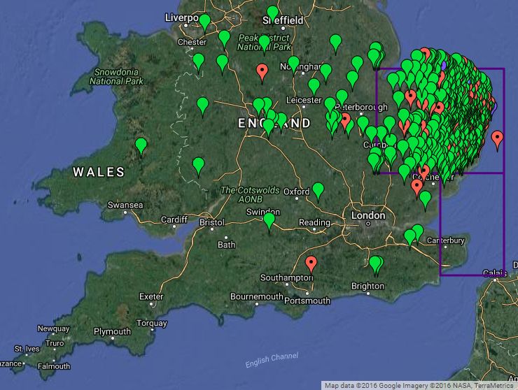
Hash Map
- There is a more up-to-date interactive version using the Google Maps API.
- Green = reached, Red = not reached, Purple = not attempted. KML Download
Expeditions
Jan - Feb - Mar - Apr - May - Jun - Jul - Aug - Sep - Oct
November
| Expedition Links | Details | ||||
|---|---|---|---|---|---|
| 2015-11-15 52 1
Sun - Map |
322/367 In a field near Waxham Sands holiday park on the coast, Norfolk, UK.
| ||||
| 2015-11-14 52 1
Sat - Map |
321/366 In a field south of Bacton and west of the railway line from Norwich to Ipswich, Suffolk, UK. | ||||
| 2015-11-13 52 1
Fri - Map |
320/365 In a meadow west of the river Tiffey, south of Barford, Norfolk, UK.
| ||||
| 2015-11-12 52 0
Thu - Map |
319/364 A road hashpoint south of the A47 near Wendling, Norfolk, UK. | ||||
| 2015-11-11 52 1
Wed - Map |
318/363 In a field north of Ringland, Norfolk, UK.
| ||||
| 2015-11-10 52 1
Tue - Map |
Failure 45/362 Between Haddon Hall and Ferry Farm, South of the Sutton Hoo, 6th and 7th century, Saxon burial grounds, Suffolk, UK.
| ||||
| 2015-11-08 52 1
Sun - Map |
317/361 In a field entrance, south of Bodham close to All Saints Church, Norfolk, UK.
| ||||
| 2015-11-07 52 1
Sat - Map |
316/360 In a field, a few paces from the perimeter between North Walsham and the coast, Norfolk, UK.
| ||||
| 2015-11-06 52 1
Fri - Map |
315/359 In a field, off a public footpath and the Suffolk, Coastal Path, west of the Butley River, Suffolk, UK.
| ||||
| 2015-11-05 52 1
Thu - Map |
314/358 Stonham Barns Golf Centre, Suffolk, UK.
| ||||
| 2015-11-04 52 0
Wed - Map |
313/357 In a field, close to a public footpath, north of Hopton, Suffolk, UK.
| ||||
| 2015-11-02 52 1
Mon - Map |
312/356 In a field east of Uggeshall, Suffolk, UK.
| ||||
| 2015-11-02 52 0
Mon - Map |
311/355 Woodland just south of the A11 and 1000 metres west of Elveden War Memorial, Suffolk, UK. |
Interesting Hashpoints
- Neil wonders if 2010-09-13_52_1 is in a tiger enclosure. The hashpoint is at Banham Zoo.
- Stealth hashing is fun but not today! Is there a get yourself arrested award?
- 2011-01-17 52 0 - A nudist beach hashpoint. Sadly it was a freezing January night.
About Sourcerer
Sourcerer lives in and likes likes 52,1 but he's seriously considering moving to 52,-1 because there are so many ocean hashpoints locally. 52,-1 is the only UK graticule surrounded by adjacent graticules that are mostly land.
- Expeditions - 363
- Coordinates reached - 318
- Coordinates not reached - 45
- Graticules attempted - 24
- 87.6% coordinates reached
- First expedition - August 7th 2010
- One hundredth expedition - August 10th 2012
- One hundredth success - February 19th 2013
- One hundred and ninety ninth expedition - February 22nd 2015 Oops.
- Two hundredth success - May 5th 2015
- One hundredth expedition in 52,1 - February 5th 2015
- One hundredth success in 52,1 - February 26th 2015
- Real name: Neil
- Home Location: Suffolk, UK 52,1
- Age: One of the oldest active geohashers. Not everyone has an updated ASG template - see Geohashers_by_age
- OpenStreetMap - New map features get uploaded to OpenStreetMap
- WikiLoc - Good walking routes get uploaded to Wikiloc.
Have all the geohashers been "Nerd Sniped"?
My user name is a play on words based on computer source-code and is a tribute to controlled folly.
I enjoy computer programming and in 1972, wrote an implementation of Conway's Game of Life in BASIC. The virtual creatures were printed on a paper roll by a mechanical teletype. Those were the days!
In 1976 I taught programming to school kids. We used Algol! We filled in coding forms and submitted them to be punched onto cards for the overnight run. The next day we'd get the error message print-outs or occasionally a successful run.
More recently I have used HTML, CSS, DOM, PHP, MySQL, Javascript and Delphi.
Since childhood, I've loved going out at night. I seem to have above average night vision. I love it when it's so dark you can almost count the photons and the night vision is grainy and a bit sparkly. This might explain love of geohashing - stealthy, often unobserved, at night. If possible, to save fuel and the planet, I visit pairs of hashpoints each side of midnight. This is great for wildlife spotting and the roads are empty. I have a spreadsheet to calculate when to set out in order to arrive at the second hashpoint at midnight. I get driving times from Google maps and estimate walking times from the UK Ordnance Survey maps available on-line using Bing maps.
Like golf and most other human activities, geohashing is totally pointless (in fact it is one of the few activities that has got an identifiable point) and it's much more fun than geocaching or golf. Many hashpoints are in the middle of a muddy field. These are a bit worthless but if there's some other attraction or challenge, I'm more likely to make the effort. In 2015 Sourcerer discovered a previously unsuspected competitive streak leading to a serious increase in geohashing activity. For some grand scale folly, see Neil's Big Walk below.
Local Terrain
The terrain in the east of England is almost flat and often quite dry. Google earth has been most useful for planning expeditions. Usually it's easy to identify hashpoints which are on private land or inaccessible for other reasons. After 100 expeditions, my success rate was 86%. In late August and autumn, most of the fields have been harvested but not yet re-planted so they are easily accessible. In the other seasons, it's often wetter and access is less easy. Hard frozen ground in deep winter is really good for geohashing.
Big Walk, Little Walks
Another folly is to walk from Cape St Vincent (Portugal) to Istanbul (Turkey). Starting in 2003, after 183 days walking and 3798 km, Neil had reached Vicenza in the north of Italy. The walk is about 50% complete. Neil is not seriously expecting to complete this walk but that is all part of the folly. He set out with his mother and sister. Both have since died. His mum reached a ripe old age. His sister died of cancer but she walked 2567 km before the cancer overcame her. She reached France. Geohashing is a good way to keep fit enough to continue with the big-walk stages.
Here are the walk details and photo gallery. You can download a [KML file] of Neil's walk for use with Google Earth. These paths are also logged at [WikiLoc].
This is what Google Earth looks like if you download the KML file. It makes more sense when you zoom in.

More Walks
Respect Zone
Here I pay tribute to awesome contributors to geohashing. If there were Oscars for geohashing, in no particular order, these would be my nominees.
- The low profile people who set up and maintain the wiki.
- Atlanta, Georgia - for breaking all sorts of records.
- Eupeodes - for making a really useful coordinate calculator and acting on suggestions for improvement.
- GeorgDerReisende - for being so active and often hitch hiking.
- NWoodruff - for breaking all sorts of records and writing bots that generate interesting statistics.
- 2011-05-21_52_14 - I wish I'd been able to go there.
- A catch all - because there is much more effort going in, invisible, because it just works.