Difference between revisions of "2011-05-21 52 1"
imported>Sourcerer (→Expedition Plans) |
imported>Sourcerer |
||
| Line 1: | Line 1: | ||
== Location == | == Location == | ||
| − | + | A couple of hundred metres west of St. Felix School, very close to a public footpath, Southwold Sufolk, UK. | |
{{meetup graticule | {{meetup graticule | ||
| Line 16: | Line 16: | ||
== Expedition Plans == | == Expedition Plans == | ||
| − | It's World Geohashing Day! Wo-hooo! And it's the End-Of-The-World! Oooooooh! So this will be my last ever geohashing expedition. My plan is to arrive at 4pm, well before the global earth quake, leave a marker and retire somewhere more comfortable to watch the end of the world and join the rapture at 11 p.m. local time! | + | It's World Geohashing Day! Wo-hooo! And it's the End-Of-The-World! Oooooooh! So this will be my last ever geohashing expedition. My plan is to arrive at 4pm, well before the global earth quake, leave a marker and retire somewhere more comfortable to watch the end of the world and join the <strike>raptor</strike> rapture at 11 p.m. local time! |
Delayed - new ETA 17:30 to 18:30. | Delayed - new ETA 17:30 to 18:30. | ||
| − | + | == The Expedition == | |
| + | |||
| + | It was a clear sunny evening with a significant sea breeze. The public footpath followed the perimeter of the school grounds and led to a point 29 metres from the hash. There was a low fence leading into a paddock. Over the fence and 29 metres later the hash was still 20 metres away on the far side of a deep tree lined drainage channel. This was GPS wierdness. There was a clear view into a sweet-corn field where the hash must be located. So after some back tracking, a short leg on the main road and a traverse of the edge of the sweet-corn, the GPS decided the hash was 20 metres away back in the paddock. Damn! The tree lined drainage channel was only about ten metres wide at this point but very densely overgrown, deep and wet. So which side was the hashpoint on? Google earth shows it clearly in the paddock so either way it's co-ordinated reached. | ||
| + | |||
| + | == Atmospheric Refraction == | ||
| + | |||
| + | Several geohashers have reported that their GPS receiver refused to reach zero. I also have experienced a hash when the GPS reached zero. By the time my camera was ready to capture the evidence, the GPS said the hash was 20 metres away. Just standing still, the GPS said I was wandering around and the track log left a random scribble. On that day there were huge convection clouds and heavy showers. I believe today also, was a day of unstable air. The cool dense damp sea breeze was undercutting the warmer drier less dense mainland air making a giant wobbly jelly prism. The error was only ten or twenty metres but that was sufficient to cause the muddle. | ||
== Photo Gallery == | == Photo Gallery == | ||
<gallery perrow="3"> | <gallery perrow="3"> | ||
| − | Image:2011-05- | + | Image:2011-05-21_52_1_Sourcerer_01.jpg|Google Earth track |
| − | Image:2011-05- | + | Image:2011-05-21_52_1_Sourcerer_02.jpg|Burnned heathland after no rain for three months |
| − | Image:2011-05- | + | Image:2011-05-21_52_1_Sourcerer_03.jpg|The Paddock and Hashpoint Location |
| − | Image:2011-05- | + | Image:2011-05-21_52_1_Sourcerer_04.jpg|Deep Water Warning |
| − | Image:2011-05- | + | Image:2011-05-21_52_1_Sourcerer_05.jpg|Nowhere to cross the channel |
| − | Image:2011-05- | + | Image:2011-05-21_52_1_Sourcerer_06.jpg|If only I was young and agile |
| − | Image:2011-05- | + | Image:2011-05-21_52_1_Sourcerer_07.jpg|St Felix School - Dead grass in May! |
| − | Image:2011-05- | + | Image:2011-05-21_52_1_Sourcerer_08.jpg|The hash is still 20 metres away! |
| + | Image:2011-05-21_52_1_Sourcerer_09.jpg|Dense vegetation near the hashpoint. | ||
</gallery> | </gallery> | ||
| − | |||
== Other Geohashing Expeditions and Plans on This Day == | == Other Geohashing Expeditions and Plans on This Day == | ||
{{expedition summaries|2011-05-21}} | {{expedition summaries|2011-05-21}} | ||
| − | |||
| − | |||
== Achievements == | == Achievements == | ||
| Line 50: | Line 54: | ||
| latitude = 52 | | latitude = 52 | ||
| longitude = 1 | | longitude = 1 | ||
| − | | date = 2011-05- | + | | date = 2011-05-21 |
| − | | achievement = | + | | achievement = Geohashing Day Success |
| − | | description = | + | | description = reaching the hashpoint, possibly twice. |
| name = Sourcerer | | name = Sourcerer | ||
}} | }} | ||
| + | {{gratuitous ribbon | ||
| + | | color = orange | ||
| + | | icon = Ate_at_myponga.png | ||
| + | | latitude = 52 | ||
| + | | longitude = 1 | ||
| + | | date = 2011-05-21 | ||
| + | | achievement = End of the World Geohash | ||
| + | | description = reaching the hashpoint 4.5 hours before the <strike>raptor</strike> rapture. | ||
| + | | name = Sourcerer | ||
| + | }} | ||
[[Category:Expeditions with photos]] | [[Category:Expeditions with photos]] | ||
[[Category:Coordinates reached]] | [[Category:Coordinates reached]] | ||
| − | |||
| − | |||
| − | |||
| − | |||
[[Category:Meetup on 2011-05-21]] | [[Category:Meetup on 2011-05-21]] | ||
[[Category:Meetup in 52 1]] | [[Category:Meetup in 52 1]] | ||
Revision as of 20:28, 21 May 2011
Contents
Location
A couple of hundred metres west of St. Felix School, very close to a public footpath, Southwold Sufolk, UK.
| Sat 21 May 2011 in Norwich: 52.3363335, 1.6496377 geohashing.info google osm bing/os kml crox |
Participants
Expedition Plans
It's World Geohashing Day! Wo-hooo! And it's the End-Of-The-World! Oooooooh! So this will be my last ever geohashing expedition. My plan is to arrive at 4pm, well before the global earth quake, leave a marker and retire somewhere more comfortable to watch the end of the world and join the raptor rapture at 11 p.m. local time!
Delayed - new ETA 17:30 to 18:30.
The Expedition
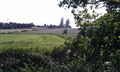
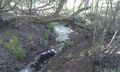
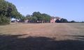
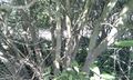
It was a clear sunny evening with a significant sea breeze. The public footpath followed the perimeter of the school grounds and led to a point 29 metres from the hash. There was a low fence leading into a paddock. Over the fence and 29 metres later the hash was still 20 metres away on the far side of a deep tree lined drainage channel. This was GPS wierdness. There was a clear view into a sweet-corn field where the hash must be located. So after some back tracking, a short leg on the main road and a traverse of the edge of the sweet-corn, the GPS decided the hash was 20 metres away back in the paddock. Damn! The tree lined drainage channel was only about ten metres wide at this point but very densely overgrown, deep and wet. So which side was the hashpoint on? Google earth shows it clearly in the paddock so either way it's co-ordinated reached.
Atmospheric Refraction
Several geohashers have reported that their GPS receiver refused to reach zero. I also have experienced a hash when the GPS reached zero. By the time my camera was ready to capture the evidence, the GPS said the hash was 20 metres away. Just standing still, the GPS said I was wandering around and the track log left a random scribble. On that day there were huge convection clouds and heavy showers. I believe today also, was a day of unstable air. The cool dense damp sea breeze was undercutting the warmer drier less dense mainland air making a giant wobbly jelly prism. The error was only ten or twenty metres but that was sufficient to cause the muddle.
Photo Gallery
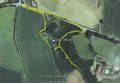
Google Earth track
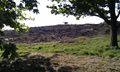
Burnned heathland after no rain for three months
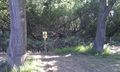
The Paddock and Hashpoint Location
Deep Water Warning
Nowhere to cross the channel
If only I was young and agile
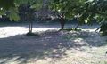
St Felix School - Dead grass in May!
The hash is still 20 metres away!
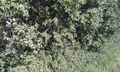
Dense vegetation near the hashpoint.


Other Geohashing Expeditions and Plans on This Day
Expeditions and Plans
| 2011-05-21 | ||
|---|---|---|
| Orlando, Florida | Rhonda, Aberro | In a wooded area near a small lake. Think there will be alligators? |
| Langtang National Park, Nepal | user:thepiguy | 1km over the Tibetan border at 5500m in altitude. Approximately 10km west o... |
| Atlanta, Georgia | NWoodruff | Off to the side of the road in Sharpsburg. Google map [1] Get there early, be... |
| Newark, New Jersey | Jevanyn | D & R Canal path, in Princeton Township. The tow path on the east side of t... |
| Portland, Oregon | Jim | In the Willamette River near West Linn. Yeah: In. |
| München, Germany | Nola17 | on a field near a field track, situated near Neufahrn, North of Munich Co... |
| Surrey, British Columbia | Wade, Robyn, Arbron, Elbie | Partway across the Pitt River near Siwash Island. Meet at the boat launc... |
| Vancouver, British Columbia | Someone went | See 2011-05-21 49 -122, which is in the Surrey graticule. |
| Bamberg, Germany | Danatar | at the edge of a forest near Ansbach, the capital of the administrative reg... |
| Mannheim, Germany | euterkuh | In the woods right at Sandhausen. |
| Vernon, British Columbia | Juventas | North of Bouleau Lake, west of Westside Road. |
| Norwich, United Kingdom | Sourcerer | A couple of hundred metres west of St. Felix School, very close to a public... |
| Berlin, Germany | Someone went | Somewhere |
| Frankfurt (Oder), Germany | Aperfectring, Ekorren, Mampfred, LadyBB, lyx, relet, Crox, { | A swamp in western Poland. Border jumping for all! |
Achievements
Sourcerer earned the Geohashing Day Success
|
Sourcerer earned the End of the World Geohash
|