Difference between revisions of "Auckland, New Zealand"
imported>JimmyNZ m (→Photos) |
imported>Greenslime m (+ 1 Geohashes Reached) |
||
| Line 80: | Line 80: | ||
==Geohashes Reached== | ==Geohashes Reached== | ||
<!-- Note to editors: please keep the order from newest to oldest --> | <!-- Note to editors: please keep the order from newest to oldest --> | ||
| − | *[[2011-12-19 -36 174|2011-12-19]] - [[User:Greenslime|Greenslime]] - | + | ===2012=== |
| + | *[[2012-01-09 -36 174|2012-01-09]] - [[User:Greenslime|Greenslime]] - Driveway, Northcote | ||
| + | |||
| + | ===2011 (8)=== | ||
| + | *[[2011-12-19 -36 174|2011-12-19]] - [[User:Greenslime|Greenslime]] - Woodhill Forest, Muriwai Beach | ||
*[[2011-10-11 -36 174|2011-10-11]] - [[User:Greenslime|Greenslime]] - Roadside, Glen Innes | *[[2011-10-11 -36 174|2011-10-11]] - [[User:Greenslime|Greenslime]] - Roadside, Glen Innes | ||
*[[2011-10-05 -36 174|2011-10-05]] - [[User:Greenslime|Greenslime]] - Woodhill Forest | *[[2011-10-05 -36 174|2011-10-05]] - [[User:Greenslime|Greenslime]] - Woodhill Forest | ||
| Line 88: | Line 92: | ||
*[[2011-06-26 -36 174|2011-06-26]] - [[User:Llama|Llama]] - Backyard, Papatoetoe | *[[2011-06-26 -36 174|2011-06-26]] - [[User:Llama|Llama]] - Backyard, Papatoetoe | ||
*[[2011-03-30 -36 174|2011-03-30]] - [[User:JimmyNZ|JimmyNZ]] - Grass clearing, Karepiro | *[[2011-03-30 -36 174|2011-03-30]] - [[User:JimmyNZ|JimmyNZ]] - Grass clearing, Karepiro | ||
| + | ===2010 (16)=== | ||
*[[2010-12-26 -36 174|2010-12-26]] - [[User:JimmyNZ|JimmyNZ]], [[User:Greenslime|Greenslime]], [[User:Krintar|Krintar]] - Median Strip, Albany | *[[2010-12-26 -36 174|2010-12-26]] - [[User:JimmyNZ|JimmyNZ]], [[User:Greenslime|Greenslime]], [[User:Krintar|Krintar]] - Median Strip, Albany | ||
*[[2010-11-04 -36 174|2010-11-04]] - [[User:Greenslime|Greenslime]] - Estuary Edge, Whenuapai | *[[2010-11-04 -36 174|2010-11-04]] - [[User:Greenslime|Greenslime]] - Estuary Edge, Whenuapai | ||
| Line 104: | Line 109: | ||
*[[2010-06-24_-36_174|2010-06-24]] - [[User:Greenslime|Greenslime]] - Shakespear Regional Park, Whangaparoa Peninsula | *[[2010-06-24_-36_174|2010-06-24]] - [[User:Greenslime|Greenslime]] - Shakespear Regional Park, Whangaparoa Peninsula | ||
*[[2010-01-24_-36_174|2010-01-24]] - [[User:Greenslime|Greenslime]] and [[User:JimmyNZ|JimmyNZ]] - Farm Paddock, Taupaki | *[[2010-01-24_-36_174|2010-01-24]] - [[User:Greenslime|Greenslime]] and [[User:JimmyNZ|JimmyNZ]] - Farm Paddock, Taupaki | ||
| + | ===2009 (2)=== | ||
*[[2009-09-05_-36_174|2009-09-05]] - [[User:TunezNZ|TunezNZ]] - East Tamaki War Memorial park sports field | *[[2009-09-05_-36_174|2009-09-05]] - [[User:TunezNZ|TunezNZ]] - East Tamaki War Memorial park sports field | ||
*[[2009-03-17_-36_174|2009-03-17]] - [[User:TunezNZ|TunezNZ]] - Corn field, Flatbush | *[[2009-03-17_-36_174|2009-03-17]] - [[User:TunezNZ|TunezNZ]] - Corn field, Flatbush | ||
| + | ===2008 (6)=== | ||
*[[2008-11-26_-36_174|2008-11-26]] - Aspirin - No.56 Parkinson Avenue | *[[2008-11-26_-36_174|2008-11-26]] - Aspirin - No.56 Parkinson Avenue | ||
*[[2008-10-02 -36 174|2008-10-02]] - [[User:TunezNZ|TunezNZ]] - East Tamaki Industrial zone | *[[2008-10-02 -36 174|2008-10-02]] - [[User:TunezNZ|TunezNZ]] - East Tamaki Industrial zone | ||
Revision as of 02:41, 9 January 2012
This page is maintained by Greenslime. Automatic updates are not desired.
|
Latest Coordinates and Map Quick-Links | |
|---|---|
| Tuesday 2024-05-21 | -36.2606757, 174.7846244 |
| Wednesday 2024-05-22 | -36.2756314, 174.2193894 |
| Northland | Whangarei | Mokohinau Islands |
| Glinks Gully | Auckland | Coromandel |
| -37,173 | Manukau City | Hamilton |
|
Today's location: geohashing.info google osm bing/os kml crox | ||


Contents
Description
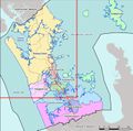
Auckland (Tāmaki-makau-rau (Māori)) is the largest city in New Zealand with a population of 1.4 million [1] (as at June 2009). The population density is low thus Auckland suffers from extreme suburban sprawl resulting in nearly every resident needing to own a vehicle to get anywhere in a respectable amount of time. Auckland straddles the Auckland Volcanic Field which contains around 50 volcanoes. It also lies on a skinny isthmus less than two kilometres wide at its narrowest point, and is surrounded by two harbours and associated inlets. Of the graticule, what isn't comprised of water or suburbia, is made up of regional parks, beaches and farmland, providing many opportunities for remote and beautiful geohash hunting adventures.
For the purpose of the Reverse regional achievement,
the Auckland graticule comprises the following
districts:
Rodney, North Shore City, Waitakere City, Auckland City, Manukau City (and Northland).
The Papakura and Franklin Districts fall under the Manukau City graticule.
Links
- Maxx for information on your public transport options in the Greater Auckland Area. Although, don't expect to get anywhere of interest quickly or easily using public transport in Auckland.
- AucklandNZ.com is the official tourism site for Auckland.
- ARC the Auckland Regional Council website.
Statistics
![]() Auckland was deflowered by gnail on 2008-06-25, although no proof was provided, and gnail was never to be seen again!
Auckland was deflowered by gnail on 2008-06-25, although no proof was provided, and gnail was never to be seen again!
![]() as of 10/3/2011 1:32:13 PM UTC,
as of 10/3/2011 1:32:13 PM UTC,
- Auckland is the
54th51st48th35th33rd32nd most active graticule in the world with141617222733 expeditions logged;
- Ranked the
51st38th32nd30th28th26th29th graticule in the world based on12141517192528 successful expeditions with coordinates reached;
- And is the most active graticule in New Zealand and can be viewed here New Zealand Most Active Graticules
- Oh, and for the record, Auckland was the 3rd most active graticule for the month of August 2010, and the 2nd most active graticule in July 2011 :)
Local Geohashers
Other hashers that have come and gone can be found here:
Geohashes Reached
2012
- 2012-01-09 - Greenslime - Driveway, Northcote
2011 (8)
- 2011-12-19 - Greenslime - Woodhill Forest, Muriwai Beach
- 2011-10-11 - Greenslime - Roadside, Glen Innes
- 2011-10-05 - Greenslime - Woodhill Forest
- 2011-10-02 - Greenslime - Paddock, Henderson
- 2011-09-27 - Greenslime - Paddock, Dairy Flat
- 2011-07-10 - JimmyNZ & Greenslime - Park, Northcote
- 2011-06-26 - Llama - Backyard, Papatoetoe
- 2011-03-30 - JimmyNZ - Grass clearing, Karepiro
2010 (16)
- 2010-12-26 - JimmyNZ, Greenslime, Krintar - Median Strip, Albany
- 2010-11-04 - Greenslime - Estuary Edge, Whenuapai
- 2010-10-22 - Greenslime - Driveway, Herald Island
- 2010-10-19 - Greenslime - Beach, Glendowie
- 2010-10-13 - Greenslime - Park, Northcote
- 2010-10-06 - Greenslime - Median Strip, Lincoln Road
- 2010-09-14 - Greenslime - Backyard, Bucklands Beach
- 2010-09-01 - Greenslime - Waitemata Golf Course, Devonport
- 2010-08-31 - Greenslime - Backyard, Remuera
- 2010-08-10 - Greenslime - House, Tindalls Beach, Whangaparoa Peninsula
- 2010-08-08 - Greenslime - Musick Point/Te Waiarohia, Bucklands Beach
- 2010-08-07 - Greenslime - Chamberland Park Golf Course, Point Chevalier
- 2010-07-20 - Greenslime - ROW, Kohimarama
- 2010-07-13 - Greenslime - Undeveloped section, Mangere South
- 2010-06-24 - Greenslime - Shakespear Regional Park, Whangaparoa Peninsula
- 2010-01-24 - Greenslime and JimmyNZ - Farm Paddock, Taupaki
2009 (2)
- 2009-09-05 - TunezNZ - East Tamaki War Memorial park sports field
- 2009-03-17 - TunezNZ - Corn field, Flatbush
2008 (6)
- 2008-11-26 - Aspirin - No.56 Parkinson Avenue
- 2008-10-02 - TunezNZ - East Tamaki Industrial zone
- 2008-09-08 - Khadgar - Helensville
- 2008-08-10 - zaf - Meters off East Coast Road, Albany
- 2008-07-28 - zaf and lan - Western Park
- 2008-06-25 - gnail - Parking lot, Mt Roskill Grammar School
Geohashes Not Reached
- 2011-07-13 - JimmyNZ - Native Bush, Riverhead
- 2011-07-12 - JimmyNZ and Greenslime - Pine Forest, Woodhill
- 2010-09-11 - JimmyNZ and Greenslime - Bush, Anawhata
- 2010-06-19 - JimmyNZ - Native Bush, Parau
- 2008-09-13 - Unknown - Whitford
Photos
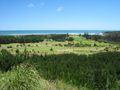
Hash point. On a hillside looking out to Muriwai Beach.
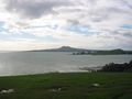
Bucklands Beach. Rangitoto Island from Musick Point
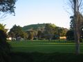
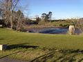
Waitemata Golf Course, Devonport. Mt Victoria
Tindalls Beach, Whangaparoa. Surprised this actually landed on land
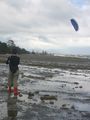
Musick Point, Bucklands Beach. Fly a kite!
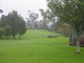
Chamberland Park Golf Course, Point Chevalier. View from the 15th tee
Mangere South. Yup, Auckland is indeed surrounded by water
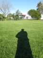
In one of our many parks
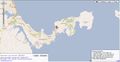
The Regions of Auckland


