I work as a database programmer and multi-purpose geek in Regensburg, Germany. Back when Geohashing started, I was toying around with infrared thermography, unconventional r/c aircraft, aerial photography, and some other odd digital photography techniques; currently I'm mostly into vintage computing and... just busy fixing electric/electronic things in general. I do seem to have started a small collection of vintage Garmin GPS receivers as well...
I do have a website but haven't updated the public-facing parts of it in over a decade.
I was a very active Openstreetmap mapper (back in 2007, when Regensburg almost completely missing on their map) and I've been a moderately, but constantly active Geocacher since 2006; these combine well with Geohashing expeditions.
I visited a lot of hashpoints in 2009, which was an amazing year - to a great extent thanks to geohashing expeditions and the people that accompanied me there. Since then my enthusiasm has faded a bit, so my weekend plans are no longer ruled by the DJIA, but I'm still looking for ones that would make for good day trips, and trying to at least pay a short visit to one or two hashpoints a year that are "too close not to go", which for me means that they're reachable from Regensburg by bicycle, including the corners of the neighbor graticules:
I have also been seen in other graticules across central Europe a few times, due to vacations and dedicated geohashing trips.
I can be found idling around in #geohashing most of the time. I've built a program to generate Maps and Statistics about graticules and expeditions on the wiki but it broke years ago and won't be fixed.
Most recent expeditions
(newest first)
|
|
|
|
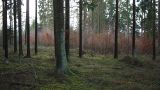 |
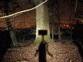
2013-12-24 49 12 in a forest north of Lorenzen, by bike.
|
 |
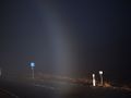
2013-11-01 47 13 next to a motorway near Salzburg (not reached).
|
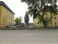 |
2013-09-25 49 12 on a military base in Regensburg (not reached).
|
 |
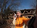
2013-07-28 49 11 in a forest halfway between Amberg and Schwandorf, by bike with mojibake.
|
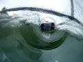 |
2013-07-23 48 12 in the Danube river near Bad Abbach. Reached by proxy through a GPS in a bottle, with Tomcat.
|
 |
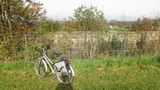
2013-04-24 49 12 on Hermann-Köhl-Straße in Regensburg, by bike.
|
 |
2013-03-03 49 12 next to the eastern bypass in Regensburg, by bike.
|
 |
2012-10-19 49 12 in the Donau river near dawidi's office, by bike (not reached).
|
 |
2012-09-23 49 12 next to a car workshop in Regensburg, on foot with mojibake.
|
 |
2012-03-30 49 12 on a road construction site in northern Regensburg, by bike.
|
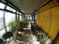 |
2012-03-17 48 12 in the Biology building on Regensburg's Uni campus, by bike with mojibake (not reached).
|
 |
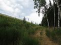
2012-03-02 48 12 on a road in the Laber valley, by bike.
|
 |
2012-01-26 49 12 at the edge of a forest near Lorenzen, by bike with mojibake.
|
 |
2012-01-15 49 11 in a forest east of Amberg, by bike with mojibake.
|
 |
2011-12-22 49 12 in an industrial area in eastern Regensburg, by bike.
|
 |
2011-12-12 49 12 north of Kneiting, by bike with mojibake.
|
... and 99 other expeditions before that!
Most recent achievements
... and several other achievements (virgin, drag-along, deja-vu, proxy, hashcard, frozen, meet-up, midnight, water...) which I've moved to a separate page.
I'm particularly looking for opportunities for these in the future:
a Border geohash in the Czech Republic, more Proxy Geohash variants, MNIMB Geohash, Consecutive Geohash, more Meet-Up Achievements, Origin Geohash, Tron achievement.


