Difference between revisions of "Main Page"
(→Recent Expeditions) |
|||
| (788 intermediate revisions by more than 100 users not shown) | |||
| Line 1: | Line 1: | ||
| − | + | __NOTOC__ | |
| + | = The Adventure Starts Here = | ||
| − | [[ | + | '''[[Geohashing]] is a global game of spontaneous adventure generation with over 17,000 expeditions since 2008.''' You will explore random locations, meet fellow geohashers, brave the elements, unlock [[Achievements|achievements]], and then come back here to '''[[expedition|document your expedition]]'''. |
| − | [[Image: | + | [[Image:Flag of Catalonia.png|15px]] [[Pàgina Principal|Català]] - [[Image:Flag of Germany.png|15px]] [[Hauptseite|Deutsch]] - [[Image:Flag of Spain.png|15px]] [[Image:Flag of Mexico.png|15px]] [[Image:Flag of Chile.png|15px]] [[Página Principal|Español]] - [[Image:Flag_of_France.png|15px]] [[Accueil|Français]] - [[Image:Flag of Italy.png|15px]] [[Pagina Principale|Italiano]] - [[File:Flag of Poland.png|15px]] [[Strona główna|Polski]] - [[Image:800px-Flag of Sweden.png|15px]] [[Huvudsida|Svenska]] - [[geohashing:translation|other languages]].{{QUOTER}} |
| − | + | [[Image:Coordinates.png|thumb|400px|[[The Algorithm]] was invented for [[xkcd]] [http://www.xkcd.com/426/ comic #426], published on 21 May 2008.]] | |
| − | + | == How to play? == | |
| − | + | # Get '''[https://geohashing.info/ today's coordinates]''' with a [[Geohashing:Coordinate_calculators|coordinate calculator]] | |
| + | # '''[[A beginner's guide|Go there]]''' (or as close as you safely and legally can) | ||
| + | # '''[[Special:UserLogin|Create an account]]''' <small>(Returning after a break? All accounts created before 2020-02-02 [[Dark Ages|were deleted]]; you'll need to sign up again)</small> | ||
| + | # '''[[Expedition|Write about]]''' your expedition! | ||
| − | + | == How does Geohashing work? == | |
| + | Everyday, an [[algorithm]] generates a random coordinate from stock market data. That coordinate can be applied to every 1°×1° latitude/longitude ''[[graticule]]'' in the world, giving a point that might be in a field, a forest, a city, or even [[Water Geohash|out at sea]]! Everyone in the world gets the same set of coordinates relative to their graticule. | ||
| − | + | Each day, people try to get their nearest generated coordinate, for an adventure, to discover somewhere new, or to meet up with other geohashers. Afterwards, you can '''[[expedition|document your expedition]]'''. The rest of us would love to read your story, see your photos, and cheer your success (or commiserate with your [[Achievements#Consolation_Prizes | failure]])! Join the other 'spot spotters', be out standing in your field and use this wiki to document the daily coordinates (geohashes) you’ve been to or tried to reach. | |
| − | + | Each day there is also a single [[globalhash]] somewhere on Earth: rare, valued and much harder to reach. | |
| − | + | {{Getting started}} | |
| − | + | {{New on the wiki}} | |
| − | + | == Official xkcd meetups == | |
| + | {{:Saturday meetup}} | ||
| − | + | == Gallery of recent expeditions == | |
| + | Every expedition should have one photo in that day's gallery, selected manually. Please add yours with the "add" link. If that day's gallery hasn't been started yet, please start it. | ||
| − | + | * [[Template:Expedition Images2/How-to|How to add your own expedition photos.]] | |
| + | * [{{fullurl:{{FULLPAGENAME}}|action=purge}} Refresh the cache] (if your image doesn't show up) | ||
| − | |||
| − | + | <!-- AUTOMATED BY User:relet. Direct comments/questions/complaints about the automation process or the new gallery format to his user talk, or visit [[Template:Recent Images2]] --> | |
| + | {{Recent Images2}} | ||
| − | == | + | == Recent and Upcoming Coordinates == |
| + | <!-- | ||
| − | + | THIS SECTION HAS BEEN COMPLETELY AUTOMATED BY User:Tjtrumpet2323. LEAVE MESSAGES ON HIS TALK PAGE WITH CONCERNS. | |
| − | |||
| − | + | -->{{Next Saturday}} | |
| − | |||
| − | |||
| − | |||
| − | |||
| − | |||
| − | |||
| − | + | * {{Coordinates list}} | |
| + | * {{Expedition archive recent}} | ||
| + | |||
| + | {{disclaimer}} | ||
| − | |||
| − | |||
| − | |||
| − | |||
| − | |||
| − | |||
| − | + | == All recent expeditions == | |
| − | + | [[Geohashing:Current events|List of all recent expeditions, including those without photos.]] | |
| − | [ | ||
| − | + | ==Recent non-expeditions== | |
| + | This section documents hash expeditions that geohashers ''wish'' they could make, but have not been able to for the reasons stated. | ||
| − | + | [[Recent_non-expeditions#2013|2013]] - [[Recent_non-expeditions#2014|2014]] - [[Recent_non-expeditions#2015|2015]] - [[Recent_non-expeditions#2017|2017]] - [[Recent_non-expeditions#2020|2020]] | |
| − | + | <!--- Please... Add other heroic non-expeditions anywhere that is appropriate.---> | |
| − | |||
| − | -- | + | <!-- |
| − | + | ###### !!! POSTED !!! NO TRESPASSING !!! ################################## | |
| − | + | IF YOU ARE READING THIS (and were hoping to add your expedition picture to the gallery) YOU HAVE TAKEN A WRONG TURN. TRY CLICKING THE 'add' BUTTON NEXT TO THE DAY OF YOUR EXPEDITION IN THE GALLERY. | |
| − | + | Click on the link "Click here to learn how to add your own expedition pictures." above the gallery for more information. | |
| − | + | ###### !!! POSTED !!! NO TRESPASSING !!! ################################## | |
| − | + | //--> | |
| − | + | {{#css: | |
| − | + | #firstHeading { display: none } | |
| − | + | }} | |
| − | |||
| − | |||
| − | |||
| − | |||
| − | |||
| − | |||
| − | |||
| − | |||
| − | |||
| − | |||
| − | |||
| − | |||
| − | |||
| − | |||
| − | |||
| − | |||
| − | |||
| − | |||
| − | |||
| − | |||
| − | |||
| − | |||
| − | |||
| − | |||
| − | |||
| − | |||
| − | |||
| − | |||
| − | |||
| − | |||
| − | |||
| − | |||
| − | |||
| − | |||
| − | |||
| − | |||
| − | |||
| − | |||
| − | |||
| − | |||
| − | |||
| − | |||
| − | |||
| − | |||
| − | |||
| − | |||
| − | |||
| − | |||
| − | |||
| − | |||
| − | |||
| − | |||
| − | |||
| − | |||
| − | |||
| − | |||
| − | |||
| − | |||
| − | |||
| − | |||
| − | |||
| − | |||
| − | |||
Latest revision as of 02:59, 17 May 2024
The Adventure Starts Here
Geohashing is a global game of spontaneous adventure generation with over 17,000 expeditions since 2008. You will explore random locations, meet fellow geohashers, brave the elements, unlock achievements, and then come back here to document your expedition.
![]() Català -
Català - ![]() Deutsch -
Deutsch - ![]()
![]()
![]() Español -
Español - ![]() Français -
Français - ![]() Italiano -
Italiano - ![]() Polski -
Polski - ![]() Svenska - other languages.
Svenska - other languages.
| “ | "To be swallowed by a peat crevasse followed by a wet land collapse would be an interesting way to meet ones doom. You'd be found three thousand years later, well preserved, with a Crox poster!"
|
” | |
| find some more great geohashing quotations here. | |||

How to play?
- Get today's coordinates with a coordinate calculator
- Go there (or as close as you safely and legally can)
- Create an account (Returning after a break? All accounts created before 2020-02-02 were deleted; you'll need to sign up again)
- Write about your expedition!
How does Geohashing work?
Everyday, an algorithm generates a random coordinate from stock market data. That coordinate can be applied to every 1°×1° latitude/longitude graticule in the world, giving a point that might be in a field, a forest, a city, or even out at sea! Everyone in the world gets the same set of coordinates relative to their graticule.
Each day, people try to get their nearest generated coordinate, for an adventure, to discover somewhere new, or to meet up with other geohashers. Afterwards, you can document your expedition. The rest of us would love to read your story, see your photos, and cheer your success (or commiserate with your failure)! Join the other 'spot spotters', be out standing in your field and use this wiki to document the daily coordinates (geohashes) you’ve been to or tried to reach.
Each day there is also a single globalhash somewhere on Earth: rare, valued and much harder to reach.
Learn more
How to geohash:
- Beginner's guide - start here
- Guidelines to follow
- Frequently asked questions
- Map applications that may help you get there
- Geohashing guides on various topics
Other people's expeditions:
- geohashing.win - browse all expeditions on a map
- Hall of Amazingness
- Maps and statistics
Get involved
- Find a geohash using a coordinate calculator
- Find others in your local area
- Chat on Discord or IRC #geohashing chat on slashnet (web interface)
- Create your user page and become a part of the community!
news archive • Edit What's new on the wiki?
- The Democracy achievement has been added.
- The Skate geohash achievement has been added.
- The Climb achievement has been added.
- The most active graticule for 2024-04 was 52,7.
- The Eclipse achievement has been added.
- The renaming process for the MNIMB, MNB, and Virgin Graticule achievements/consolation prizes is ongoing.
More pages needing discussion • Discussion archive • Edit Now discussing - please join in:
- Make sure to check out and give your thoughts on the Proposed achievements!
- For more general discussions, find us here:
- IRC: #geohashing on irc.slashnet.org
- Discord: discord.gg/BvRfGat
Official xkcd meetups

Based on the title text from the comic that established geohashing, the "official" meetup day was interpreted as being Saturday; that is, the day one would have the best chance of meeting others -- see also Mouseover Day. Additionally it was decided through convention that a good meeting time would be 16:00 local time (4:00 P.M.)¹
However, neither of these are hard rules, and they were formulated at a very different early stage in the sport's history. Nowadays and for quite awhile actually, any date or time can be good (or bad, depending on how many other hashers are near you) for meeting up, especially if prearranged. Note that this only applies to that day’s normal local geohash or globalhash coordinates, if you try to go to an alternate location without telling anyone else, it's highly unlikely you'd meet up with a hasher there (obviously).
¹Or earlier if that would be too close to sunset during the winter, or other quirks of temporal tradition; see your local graticule page for consensus there.
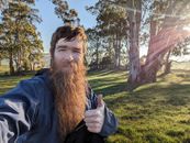
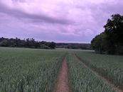
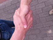
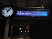
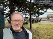
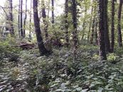
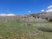
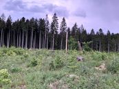
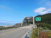
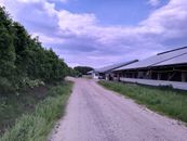
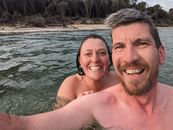
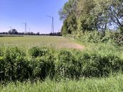
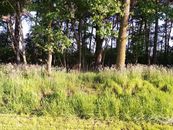
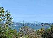
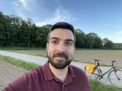
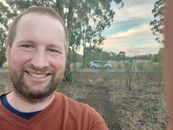
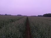
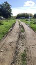
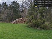
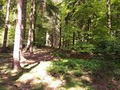
Gallery of recent expeditions
Every expedition should have one photo in that day's gallery, selected manually. Please add yours with the "add" link. If that day's gallery hasn't been started yet, please start it.
- How to add your own expedition photos.
- Refresh the cache (if your image doesn't show up)
| Recent Expeditions | |||||||||
|
| |||||||||


Recent and Upcoming Coordinates
The coordinates for the next Saturday meetups, scheduled for 25 May 2024, will be based on the Dow’s opening price published at 09:30 EDT (13:30 UTC) on Friday 24 May. See timeanddate.com to convert this time to your local time zone.
- Coordinates: Thu 23 May* | Wed 22 May | Tue 21 May | Mon 20 May | Sun 19 May | Sat 18 May | Fri 17 May | Thu 16 May
* Only known for regions east of 30W longitude. Coordinates for regions to the west announced 13:30 UTC, 23 May. - View expedition archives for: May 2024 | April 2024 | March 2024 | More...
All recent expeditions
List of all recent expeditions, including those without photos.
Recent non-expeditions
This section documents hash expeditions that geohashers wish they could make, but have not been able to for the reasons stated.
2013 - 2014 - 2015 - 2017 - 2020