About Norwich
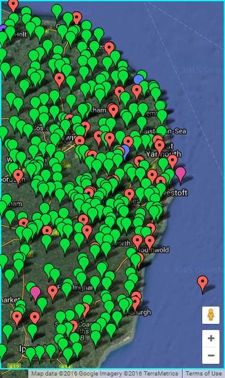
The 52,1 graticule covers the parts of the United Kingdom from 52° to 53° latitude, and from 1° to 2° longitude. This includes parts of Norfolk and Suffolk with their coastlines. The Reverse regional achievement is easily achieved by geohashing both these counties. 57% is land. In an average month there might be 17 land geohashes with 15 reachable so it's a "coin toss" whether or not you can reach coordinates on any given day. The north coast is in sea area Humber. The east is Thames.
Most of the terrain is agricultural. Some areas are very flat. Other areas include low rolling hills. This easy terrain, full of public footpaths, is balanced by coastal mud flats and salt marshes which can be tricky to reach. The Norfolk and Suffolk Broads cover a sizeable area with rivers, canals and man-made broads (lakes) created by peat digging.
2023 Expeditions
If you're planning an expedition, please add to this section. People actively watch it and they might try to join you.
May
- 409/471 2023-05-21 (Sunday): PeterRoder visited a field near Berney Arms to celebrate Geohashing Day, and missed his train home.
2022 Expeditions
None recorded.
2021 Expeditions
November
2020 Expeditions
None recorded.
2019 Expeditions
July
- 407/469 2019-07-14 (Sunday): Sourcerer visited a residential street in north Norwich, Norfolk, UK.
May
- 406/468 2019-05-26 (Sunday): Sourcerer visited a field perimeter near Denton, Norfolk, UK.
- 405/467 2019-05-25 (Saturday): It was Mouseover Day. Sourcerer visited a field between Mutford and Carlton Colville, Suffolk, UK arriving at about 1:30pm.
2018 Expeditions
October
- 404/466 2018-10-03 (Wednesday): Sourcerer visited a residential street in Haddiscoe, Norfolk, UK.
May
- 403/465 2018-05-21 (Monday): Sourcerer visited a field perimeter track east of the disused airfield at Coltishall, Norfolk, UK.
- 402/464 2018-05-16 (Wednesday): Sourcerer visited a road hashpoint, south of Huntingfield, Suffolk, UK.
February
January
- 400/462 2018-01-31 (Wednesday): Sourcerer visited a field perimeter footpath at Rumburgh, Suffolk UK. 12 hours earlier he visited 2018-01-31_43_19 in Montenegro, gaining "Mile High", "Air Geohashes" and a few other achievements.
2017 Expeditions
December
- 62/461 danheller intended to get to the 2017-12-23 location at some point. Driving from Sheffield, so didn't make it by 4pm, nor later due to massive clothes packing error. :(
- Rats - I'm in Staffordshire or I would have tried this one. --Sourcerer (talk) 14:04, 23 December 2017 (UTC)
- Sourcerer wants to know what "massive clothes packing error" could prevent an expedition. We have "geoflash" for nakedness, "Hobbit" for bare feet, "Formal Attire" for suits and waistcoats and general silly attire is to be encouraged.
November
October
September
July
- 394/455 2017-07-31 (Mon): Sourcerer visited a public footpath half way down a field perimeter at South Green, Norfolk, UK.
- 393/454 2017-07-20 (Thu): Sourcerer visited a field perimeter at Old Hall Farm, St Nicholas South Elmham, Suffolk, UK.
- 61/453 2017-07-13 (Thu): Sourcerer failed to reach a field east of the Sotterley Hall estate, Suffolk, UK.
- 392/452 2017-07-12 (Wed): Sourcerer visited a field south east of Bungay, Suffolk, UK.
- 391/451 2017-07-05 (Wed): MagicIan got pretty darn close to the hashpoint on a road in Hethel, Norfolk UK.
June
- 390/450 2017-06-24 (Sat): Sourcerer reached a beech wood north of Aylsham, Norfolk, UK.
- 389/449 2017-06-22 (Thu): Sourcerer reached Lowestoft and Yarmouth Rugby Union Football Club, Suffolk, UK.
May
- 60/448 2017-05-11 (Thu): Sourcerer failed to reach the point just off the A11 at Wymondham, Norfolk, UK.
April
March
- Sea points: 2, 3, 4, 6, 9, 10, 11, 12, 13, 19, 20, 21, 25, 29, 30, 31
- Not attempted: 8, 14, 17, 22, 23, 24, 26, 27, 28
- Expeditions ...
- 383/442 2017-03-18 (Sat): Sourcerer reached the residential point in Diss, Norfolk, UK.
- 382/441 2017-03-16 (Thu): Sourcerer reached the roadside point between Stoven and Uggeshall, Suffolk, UK.
- 381/440 2017-03-15 (Wed): Sourcerer reached the point in a field between St. Margaret and St. James, South Elmham, Suffolk, UK.
- 380/439 2017-03-07 (Tue): Sourcerer reached the point in a field by Tunstall Forest, Suffolk, UK.
- 379/438 2017-03-05 (Sun): Sourcerer reached the point in Stoke Park Drive, Pinewood, South Ipswich, Suffolk, UK.
- 59/437 2017-03-01 (Wed): Sourcerer failed to reach the point in Pakefield Industriual Estate, Suffolk, UK.
February
- Sea points: 2, 6, 8, 18, 25, 27, 28
- Not attempted: 1, 3, 4, 5, 7, 9, 14, 15, 16, 17, 19, 20, 21, 22, 23, 24,
- Expeditions ...
- 58/436 2017-02-26 (Sun): Sourcerer failed to reach a field between Snape and Aldeburgh, Suffolk, UK.
- 378/435 2017-02-13 (Mon): Sourcerer visited a field between Hempnall and Fritton, Norfolk, UK.
- 377/434 2017-02-12 (Sun): Sourcerer visited a field between Tanningtom and Maypole Green, Suffolk, UK.
- 376/433 2017-02-11 (Sat): Sourcerer visited a field west of the dry ski slopes, south of Ipswich, Suffolk, UK.
- 375/432 2017-02-10 (Fri): Sourcerer visited a meadow close to Brampton Hall, Suffolk, UK.
January
Mannheim, Germany tied with Norwich this month for coordinates reached.
- Sea points: 1, 3, 4, 8, 14, 16, 17, 21, 22, 25, 27, 29,
- Not attempted: 2, 7, 9, 10, 11, 12, 13, 15, 18, 19, 20, 26, 28, 30, 31
- Expeditions ...
- 374/431 2017-01-24 (Tue): Sourcerer visited a field between Stradbroke and Wingfield, Suffolk, UK.
- 373/430 2017-01-23 (Mon): Sourcerer visited a field between Ilketshall Saint Andrew and Beck's Green, Suffolk, UK.
- 372/429 2017-01-06 (Fri): Sourcerer visited a heathland point south of Westleton, Suffolk, UK. There might be dense gorse!
- 371/428 2017-01-05 (Thu): Sourcerer visited a field south of Toft Monks, Norfolk, UK.
Annual Expedition Archives
| Present Year
|
Total
|
Expeditions
|
Reached
|
Retro
|
Retro Reached
|
Expeditions retro-visited
|
| 2016
|
141
|
140
|
121
|
1
|
1
|
5
|
| 2015
|
178
|
178
|
155
|
0
|
0
|
12
|
| 2014
|
15
|
15
|
14
|
0
|
0
|
2
|
| 2013
|
22
|
21
|
19
|
1
|
1
|
1
|
| 2012
|
22
|
22
|
18
|
0
|
0
|
1
|
| 2011
|
25
|
25
|
21
|
0
|
0
|
0
|
| 2010
|
25
|
24
|
21
|
1
|
1
|
2
|
| 2009
|
2
|
2
|
2
|
0
|
0
|
0
|
Graticule Level Achievements
2016
|
The Norwich, United_Kingdom graticule (52 1) earned the Most Active Graticule achievement
- in the category coordinates reached by being the location of 364 successful expeditions from the start of geohashing until November 29, 2016.
|
Norwich, United Kingdom and Utrecht, Netherlands both reached four hashpoints.
- NWoodruff's counting method possibly includes retro-hashes. With this counting method, on this day, Norwich became the all-time most active graticule for Expeditions.
2015
2013
2011
Local Geohashers
- Aaronboardley, based in Lowestoft.
- Benjw, based in Cambridge, has visited this graticule.
- ChromeCrusaders, based in Great Yarmouth, Norfolk.
- Homonecloco probably visited 2014-05-17 52 1.
- Jaydublu, based on the North Norfolk coast, doesn't do boats or Suffolk.
- MagicIan, based in Mulbarton, just south of Norwich. His Geohashing exploits are sporadic to say the least.
- PaintedJaguar, based in the Cambridge graticule.
- Sourcerer, lives in Bungay, Suffolk. He visits local hashpoints and on his travels, any hashpoint near enough to reach.
Graticule Statistical Charts
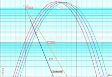
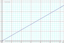
Check out the probabilities of getting consecutive hashpoints and find out how likely it is to get certain numbers of land hashpoints in a month.
This CALCULATOR was used to generate the statistics.


