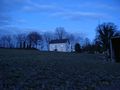
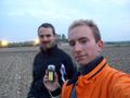
I work as a database programmer and multi-purpose geek in the "IT-Speicher" in Regensburg, Germany, and toy around with unconventional r/c aircraft, aerial photography and some other odd digital photography techniques in my free time.
I do have a website but for the moment it is horribly outdated.
I'm into Openstreetmap and Geocaching also; these combine well with Geohashing expeditions.
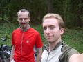
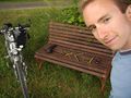
I now rather frequently visit hashpoints on any day (or during the night, if necessary) if I find the time, and the coordinates happen to be reachable from Regensburg by bicycle, including the corners of the neighbor graticules:
I can be found idling around in #geohashing most of the time, and I've built a program to generate Maps and Statistics about graticules and expeditions on the wiki.
Been there...
(newest first)
|
|
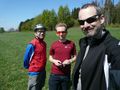 |
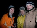
2009-04-19 49 12 in a meadow about 15km east of Weiden, by train and bike with Tomcat and Hans.
|
 |
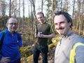
2009-04-11 48 13 in a forest about 20km southeast of Passau, by train and bike with Tomcat and Hans.
|
 |
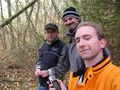
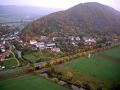
2009-04-03 49 12 in a beautiful, mountainous forest north of Ramspau, with Tomcat and Hans.
|
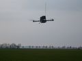 |
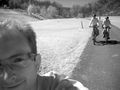
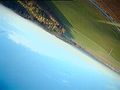
2009-03-30 48 12 in a field east of Neutraubling, where I cycled with Tomcat and Hans, and flew my quadrocopter to the coordinates.
|
 |
2009-03-28 48 11 in a fenced parking lot/garbage dump between Feldmoching and Hasenbergl, north of Munich, where I failed to meet Zb.
|
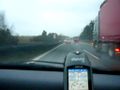 |
2009-03-23 49 12 on the Autobahn A93 near Regenstauf, with Tomcat and Hans in their car.
|
 |
1981-09-10 49 12 where I went with Jockal on 2009-03-21 to check out a suspicious coincidence related to my origin.
|
 |
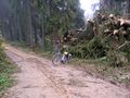
2009-03-20 49 11 in a small chunk of forest on a former military training range near Hemau, reached by bike with Tomcat and Hans.
|
 |
2009-03-17 48 11 in the Painten forest west of Viehhausen, where I cycled together with Tomcat.
|
 |
2009-03-11 49 12 in a smelly cabbage field north of Haslbach, where I met with Tomcat.
|
 |
2009-03-06 49 12 in the mountains north of Bach an der Donau, where Tomcat, Hans and I failed again due to snow, ice, darkness and confusing forest tracks.
|
 |
2009-02-27 48 12 in a meadow about 20km east of Regensburg, which we reached exactly at midnight on the way home from the previous expedition.
|
 |
2009-02-26 48 12 in a muddy field west of Landau an der Isar, where we celebrated Tomcat's birthday.
|
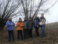 |
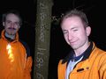
2009-02-22 51 10, an all-day meetup expedition of six geohashers, next to a creek between Niederspier and Wasserthaleben in rural Thuringia.
|
 |
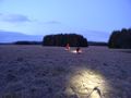
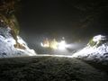
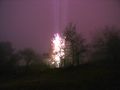
2009-02-18 49 11 in a snowy field, where Tomcat, Hans and I went in their car after sunset and drew lightmarks.
|
 |
2009-02-05 49 11 under a tree near Schönhofen, where Tomcat and I walked from the next village.
|
 |
2009-02-04 49 12 in the mountains north of Bach an der Donau, where I couldn't get to because the forest paths were icy and slippery.
|
 |
2009-01-31 48 12 among some trees, east of Barbing. Cycled there in the afternoon and made a time-lapse video of the ride.
|
 |
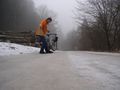
2009-01-28 49 11 on an access road between business buildings in Amberg. Went there by bike and train in the evening after work, and was spied upon by relet via a webcam.
|
 |
2009-01-12 48 12 in the same field as 2008-12-18 48 12 but 400m to the east. Cycled there before work, around 8:30. No sticky mud this time :-P
|
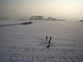 |
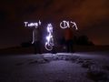
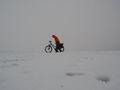
2009-01-11 48 12 in a snowy field, with Tomcat and Hans. Wrote stuff into the snow and flew my paraplane to photograph the work from above.
|
 |
2008-12-30 49 12 on a wooded hill above Unterlichtenwald, about 15km east of Regensburg. Reached the coordinates together with Tomcat at 20:00.
|
 |
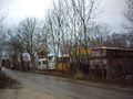
2008-12-24 49 12 inside a Fristo beverage depot in Regensburg, near the Donaueinkaufszentrum. Arrived at 9:00 and explained geohashing to the interested shop leasee.
|
 |
2008-12-18 48 12 In a field south of Neutraubling. Made a total mess of myself and my bike to get there (after work).
|
 |
2008-11-01 48 12 In a field north of Bad Abbach, about 10km from Regensburg. Went there by bike with Tomcat and Hans around 16:00, and also flew my "X-3D-BL" quadrocopter over the field.
|
 |
2008-10-18 49 12 On a hill above Bach an der Donau, 15km east of Regensburg. I met Tomcat and a drag-along there at 9:00 in the morning.
|
 |
2008-10-14 49 12 In Sulzbach an der Donau, under an apple tree, 10km east of Regensburg, with Tomcat and my R/C paraplane.
|
 |
2008-10-11 49 12 Near Hirschling, in a forest above the Regen valley, 25km north of Regensburg.
|
 |
2008-09-29 49 11 Very close to Eilsbrunn, in a field west of Regensburg, with Tomcat.
|
 |
2008-08-09 49 12 Near Hainsacker, in a forest north of Regensburg, with Tomcat
|
 |
2008-06-15 49 11 Near Siebeneichen, in a field east of Amberg (my first, and for now the longest expedition)
|
...done that:
Template:Virgin graticule
|
dawidi, with Tomcat and Hans, almost earned the Speed Racer geohash Achievement
- by passing through the (49, 12) geohash on 2009-03-23 at 130 km/h (the advisory maximum speed), because Unhandled Exception in 'Speed Racer Achievement': property 'legal speed limit' not implemented..
|
|
Template:Virgin graticule
Template:Hashcard achievement
Template:Virgin graticule
Template:Virgin graticule
... and I'm particularly looking for opportunities for these in the future:
Water Geohash, another Border geohash, more Proxy Geohash variants, Calendar Girl Achievement, MNIMB Geohash, Consecutive Geohash, Multihash, more Meet-Up Achievements, Birthday Geohash, Sunrise geohash, Origin Geohash.


