


Welcome to the Geohashing Community Wiki. Geohashing is a Spontaneous Adventure Generator, brought to you by the xkcd webcomic.
Contents
- 1 How it works
- 2 Active Graticules
- 3 Implementations
- 4 Recent and Upcoming Expeditions
- 5 Wednesday 28 May 2008
- 6 Tuesday 27 May 2008
- 7 Monday 26 May 2008
- 8 Sunday 25 May 2008
- 9 Saturday 24 May 2008
- 10 Friday 23 May 2008
- 11 Thursday 22 May 2008
- 12 Wednesday 21 May 2008
- 13 Known Issues
- 14 FAQ
- 15 Related Projects
How it works
Play with the coordinate calculator at http://xkcd.com/geohashing. All coordinates refer to the WGS84 datum.
Every day, the algorithm generates a new set of coordinates for each 1°×1° latitude/longitude zone (known as a graticule) in the world. They are randomly placed -- they could be in the forest, in a city, on a mountain, or even in the middle of a lake! You can use this wiki to document the daily coordinates (geohashes) you've been to.
Unless you can accurately predict the stock market down to the penny, you can't figure out what the coordinates will be ahead of time. You can first calculate a weekday's coordinates at about 9:30am ET, and on Friday morning you can calculate the coordinates for each day that weekend (sometimes even through Monday when there is a US holiday).
When visiting geohash locations, please respect the area you are visiting. Absolutely do not litter or otherwise disturb the natural integrity of the area. However, if possible, creating some kind of a marker out of nearby materials (i.e. cairn of stones, blair-witch-style 'stick figures', etc.) is encouraged.
Official xkcd meetups
Official xkcd meetups happen every Saturday afternoon at that day's normal geohash coordinates. All meetups start at 4:00pm (local destination time). If you go at these times, you might encounter other readers of xkcd. Bring games!
In such cases when it is unwise to attempt to access the generated coordinates, the Saturday meetup is postponed until a day when the algorithm provides a more suitable location. Alternatively, when the coordinates fall within a body of water, you can rent a boat and win the Water Geohash achievement.
Active Graticules
Want to find geohashers in your local area? See Active Graticules for a list of graticules with active users in them.
An interactive map is available for [Google Earth] or on [Google Maps].
Implementations
A full list of reference and practical implementations can be found on the Implementations page.
Recent and Upcoming Expeditions
The coordinates for the Saturday meetups on 18 May 2024 are now available. The coordinates for the next Saturday meetups, scheduled for 25 May 2024, will be based on the Dow’s opening price published at 09:30 EDT (13:30 UTC) on Friday 24 May. See timeanddate.com to convert this time to your local time zone. Template:30w View expedition archives for: May 2024 | April 2024 | March 2024 | More...
Wednesday 28 May 2008
Coordinates
West of -30°: 0.6874508850272152, 0.21220759334309575
East of -30°: 0.7104414955290416, 0.11273220876887029
Expeditions
- 2008-05-28 Boston, Massachusetts - Successfully Reached by mechfish, but not by his camera. Separately reached by Loch who accessed the building with his camera in hand.
- 2008-05-28 Haifa East, Israel - Unsuccessfully reached by Ynor
- 2008-05-28 Denver, Colorado - Successfully reached by Mike. Despite the weather, the view from the location/hill was beautiful.
- 2008-05-28 Mansfield, Ohio
Tuesday 27 May 2008
Coordinates
West of -30°: 0.20967755786283662, 0.10144168461237785
East of -30°: 0.12536718896775, 0.577110915397159
The first day the 30W Time Zone Rule is in effect. These coordinates became available east of -30° on Friday 23 May by combination of a Dow holiday (Memorial Day) on Monday 26 May and the new 30W Time Zone Rule, which posits that Tuesday's open would come too late in the day for eastern longitudes.
Expeditions
- 2008-05-27 St. Paul, Minnesota - Successfully reached by Marktraceur and friends.
- 2008-05-27 Munich, Germany - Successfully Reached by bock and zb.
- 2008-05-27 Bilbao, Spain - Unsuccessfully reached by Loggie: I got kidnapped instead
- 2008-05-27 Boston, Massachusetts - Successfully Reached independently by Loch and Noc.
- 2008-05-27 Clearfield, Utah - Successfully reached by Tsen and Tyler.
- 2008-05-27 Austin, Texas - Successfully reached by s3g2.
- 2008-05-27 Conway, Arkansas - Sucessfully Reached by l33tmoomba
- 2008-05-27 Vancouver, British Columbia - Successfully reached by thepiguy and srs0.
- 2008-05-27 Mansfield, Ohio
Monday 26 May 2008
Coordinates
0.673128104319 0.6073080067
Note: These coordinates became known on Friday 23 May due to a Dow holiday (Memorial Day) on Monday 26 May.
Expeditions
- Brussels, Belgium - The coordinates for Brussels, Leuven and Louvain-La-Neuve are almost within reach. They are on the Boulevard de Lauzelle (the N250 motorway) just outside of Louvain-La-Neuve. We could meet by the side of the road, or very close by in the Avenue Des Clos. An ideal moment of rest for university students with exams on the way.
- Cleveland, Ohio - In the lake. Probably not a good place to meet, unless you want to win a Water Geohash award.
- Connecticut - A PERFECT location: Rocky Hill/South Glastonbury. Take I-91 north from New Haven or south from Hartford; take Exit 23 to West. St; turn left @ Route 99/Main St.; right @ Glastonbury Ave. to the Ferry [YAY! There's a ferry, even!!!]; after crossing, you're on Ferry Ln./Route 160; continue to South Glastonbury Center and turn left on Route 17/Main St.; take 5th left onto Red Hill Dr. into a residential dead-end; turn left, proceed to cul-de-sac there; park. Official coordinates are for the backyard of the house directly ahead of you, but for the sake of being nice, I'll be at the cul-de-sac itself. The view from that spot should be amazing, and the ferry ride makes it all worthwhile. 4PM.
- Copenhagen, Denmark - A great spot in the middle of Copenhagen, right across the water from Christiania. Unfortunately, it's in someone's house.
- Glasgow, United Kingdom - A few yards off Lochlibo Road in Ayrshire, just north east of Kilwinning.
- Hamburg (West), Germany - A (the only?) junction in the small village "Klevendeich".
- London West, United Kingdom - Just a couple of minutes walk from Amersham Station, the last stop on the Metropolitan line. Just a bit of tube hopping for anyone with easy access to an Underground station and a Bank Holiday Monday to kill. Looks like it may be in a back garden however!
- Manchester, United Kingdom - A field with a nearby wooded area north east of Chorley, probably accessible, maybe farmland.
- Mansfield, Ohio Located just off a low-traffic country road outside Lexington. Good spot for a meetup.
- Newark, New Jersey - Off Route 287 in Liberty Corner, New Jersey near UAga National Golf Course. Appears to be a wooded area.
- New York City In (or on, I suppose) someone's house in Baldwin. (Map)
- Oslo, Norway - Located on Oscarsborg Festning, an island fortress. A return ticket with the ferry from Drøbak is 70 kr.
- Panama North, Panama - Right in the middle of the sea... so, I wont go... not really planning on renting a boat today... but next time, we'll have a sailboat rental ready...
- Providence, Rhode Island - A very quick hop off 95, to Route 3 North (Coventry), left on Harkney Hill, Right on Hill Farm. The map shows a tree jutting into the stream - that's it! Come join the busting of this graticule at 1pm!
- I am going to attempt the 41, -71 graticule for Monday, May 26th, off Hill Farm Rd. in Coventry. Anyone in the RI area who has a boat - this might qualify for a Water Geohash. As I don't own a boat or possess levitation skills (necessary for Dagobah geohashing), I might be resigned to taking pictures from the very close land! Edit here if looking to meet up so times can be discussed (or is 4:00pm the default?). -Patrick
- I'm attempting to find a way to get there at the moment, as I may not have access to transportation tomorrow. We (meaning anyone) can use my userpage to discuss any plans. --Yusuke 22:54, 25 May 2008 (UTC)-Yusuke
- Victor Sorry man, wish I could. Work, ya know? Can you dig?
- Richmond, Virginia - Directly on Shady Grove Road off of Pouncey Tract Road in northwest Henrico County.
- Salinas, California - Within the city of Salinas, at the corner of Fern and Alisal streets (just N of the airport)
- Santa Rosa, California - Inside Robert Louis Stevenson State Park, North of Calistoga. Looks like a hike, depending on where the park entrance is.
- St. Louis, Missouri - Just west of the St. Louis Bandits Jr. A hockey arena, off of I-40, in Chesterfield, MO.
- Sydney (West), Australia - A tree in the backyard of a house in Winmalee, near Penrith. There's a park nearby.
- Toronto, Ontario - Right next to the runway at Pearson Airport. Unlikely to be accessible!
- Trabuco Canyon, California - Located between Portola Hills and Trabuco Canyon, off of Live Oak Canyon Road.
- Tucson, Arizona - Located in the middle of the normally dry San Pedro river with dirt road(possibly requiring 4WD) access near Mammoth and San Manuel. Considering recent storm activity, it may actually have flowing water in it, giving one of the few chances of getting the Water Geohash award in this graticule. Apparetly there is a ghost town called Copper Creek nearby to the east of Mammoth as well [1]
- Vero Beach, Florida - In a farm land west of Vero beach. There is nothing close by, so if anyone else comes bring food, and games!
- Weymouth, United Kingdom Just outside a place called Abbotsbury, looks a tad inaccesible due to being out in the middle of some un-public-looking fields. Anyone with inside information of Abbotsbury and the surrounding area is encouraged to post, otherwise, if there's a pub in said Abbotsbury, that'll do!
Sunday 25 May 2008
Coordinates
0.941774852844, 0.18287359767
Expeditions
- Atlanta, Georgia - (33, -84) Someone's backyard. I'll pass.
- Aurora, Illinois -Located in a pond near the west Branch of the Du Page river, Still looks like the best Chicago Land location 2008-05-25_41_-88
- Boston, Massachusetts - (42, -71) Getting there may be difficult, as it's off the road in a residential area of Sandown, NH.
- Copenhagen, Denmark - Looks like right in the middle of the road, Hasejevej, up around Tjæreby and Meløse. Fields on either side, but there is a lake nearby, which could be nice.
- Corvallis, Oregon - A dirt parking lot for what appears to be some sort of farm a few minutes east of Rickreall. Oak Knoll Golf COurse is nearby.
- Washington (West), District of Columbia - (38, -77) A promising location at a private residence in McLean. Cerulean made it there.
- Edinburgh, United Kingdom - The garden of some terraced housing between the Meadows and Holyrood Park.
- Ft. Worth, Texas - In a small lake in a subdivision in NE Fort Worth. It looks like there is a walking trail and a park on the south and east sides of the lake.
- Glasgow, United Kingdom - Situated on the green of a hole on Kirkintilloch Golf Course. A very flat surface to have a nice picnic for 'fore'.
- Melbourne East, Australia - Six feet over someone's dead body. (Springvale Botanical Cemetery)
- Milwaukee, Wisconsin - In the middle of the road on West Edinburgh Drive, in between Waukeshau and New Berlin.
- Minneapolis SW, Minnesota - Near the intersection of Summit and Prior Avenues.
- Newark, New Jersey - Near a small pond in Haledon, NJ.
- San Antonio, Texas - On some private backroads near Canyon Lake. Probably should not attempt.
- San Diego, California - Parking might be hard to find in this Del Mar cul-de-sac.
- San Franciso, California - Bear Oaks Court, under a tree near Briones Regional Park. We'll meet for a hike at Bear Creek Staging area at 4:30 (Briones & Bear Creek Rd). 2008-05-25 37 -122.
- San Jose, California - A field east of Stockton, CA.
- St. Louis, Missouri - A nice subdivision just outside of Lewis & Clark Community College in Godf
- Swindon, United Kingdom - An inaccessible field just off the M40.
- 2008-05-25 55 12 - Reached by SolidHydrogen on a country lane near Meløse, Denmark.
Photo Gallery
- Multi-group meetups with pictures (so far)


Saturday 24 May 2008
Coordinates
0.1266480113970560, 0.5475331240942810
It was the first Saturday after the algorithm was published, and there was an xkcd meetup at 4:00pm in regions where the coordinates were reachable.
Expeditions
- Adelaide South, Australia Using South Graticule Looks Best Satellite looks promising if land is private land across road looks good.
- Anchorage, Alaska Near Tanaina Peak in the Chugach State Park. The first meet up might not be heavily attended...
- Atlanta, Georgia -- In what looks like a field off of an access road near 85 south. Picnic time!
- Aurora, Illinois - Side of a road, no one was there. Took pictures.
- Austin, Texas, United States 30.1266480113970560,-97.5475331240942810 - Looks private, but perhaps accessible.
- Baltimore, Maryland -- Coordinates are at a house on 229th st in Pasadena MD.
- Berlin, Germany Close to Erkner, reachable with public transport, on a field. Nice lakes around, worth a trip!
- Birmingham East, United Kingdom -- Private field by a main road. Should be able to get close enough for a photo.
- Boston, Massachusetts -- Coordinates are in Hopedale. The exact coordinates are in someone's house, so obviously they will not be reached within a foot, but they can expect some odd passers-by on their road.
- Brisbane, Australia(South West Graticule) -- Accessible. At the foot of Mount Moon in Moogerah Peaks National Park. 2 People visted at the designated meet up time.
- Carlisle, United Kingdom -- Several users reached a field of cows near Low Bentham, North Yorkshire.
- Champaign/Urbana, Illinois -- The first official meetup appears to be in a field near the intersection of N 1000 E Rd. and Cord 2350 Rd. N in Piatt County about 20 miles from Champaign-Urbana and about 50 miles from Bloomington-Normal.
- Charlotte, North Carolina -- 35.126648°, -80.547534°
- Chicago, Illinois -- In a field near a...something (satellite imaging is hazy) south of Woodland, IL, near the corner of E Baseline and N 1700 Rd -- near the Illinois-Indiana state line. Probably accessible, but distant -- Chicago residents may wish to use the Schaumburg graticule for Saturday's meet-up instead. (The North Shore graticule's coordinates, while technically closer, are underwater.)
- Chico, California — Actually not near Chico, but Yuba City. Looks reachable, or near enough. Convenient from Sacramento and even more so from the geocaching mega-event in Wheatland, CA.
- Cincinnati, Ohio -- Right outside of Cincinnati, seems to be a business' parking lot of some kind. Accessible.
- Cleveland, Ohio -- Perfectly located in a large park with soccer fields and a parking lot. Bringing chess.
- Conroe, Texas - Accessible. In front of somebody's house.
- College Station, Texas - Accessible. In a pasture west of Brenham, south of Burton. However you will most likely be trespassing and walking right by someones house.
- Fort Collins, Colorado - 40.126648°,-105.547534° Middle of forest in Roosevelt National Forest on the Coney Flats four-wheel-drive road (NFSR 507), 1.5 miles from the gate at Beaver Reservoir.
- Des Moines, Iowa - In a field
- Detroit, Michigan - On a road on private property
- Dresden, Germany -- A field by Brockwitz, near Coswig. Reachable.
- Eugene, Corvallis, Monmouth, and West Salem, Oregon, US -- Bigfoot sighting.
- Graz, Austria Near Strallegg, eastern part of styria: 47.400246°, 15.722771°
- Grenoble, France -- Accessible. In the forest in the Vercors Mountains. Went hiking in the area recently :) About 45mins by car from Grenoble. (45.126648°, 5.547533°) [2].
- Groningen Drenthe, North-East of the Netherlands: 53.1266480113970560, 6.5475331240942810
- Indianapolis, Indiana/Bloomington, Indiana -- Bloomington Country club in the golf course... may be pricey/imposible
- Inland Empire, California -- Accessible. Near Vintage Park in Rancho Cucamonga.
- Lafayette, Indiana -- On W IN 47, just northwest of Lebanon.
- Kyiv, Ukraine - coordinates are inside forest, about 700m far from nearest road.
- Lansing, Michigan - in the woods, not far off a road, south of Horton, MI.
- Leesburg, Virginia (also most of Jefferson & Berkeley Counties in West Virginia) -- a townhouse on the north side of Leesburg, near the corner of Clark Ct. NE and Fieldstone Dr. NE: [3]
- London West, United Kingdom -- In some woods off the A281 near Cranleigh in Surrey. Looks like there's a path going right to it! 51.1266480113970560,-0.5475331240942810
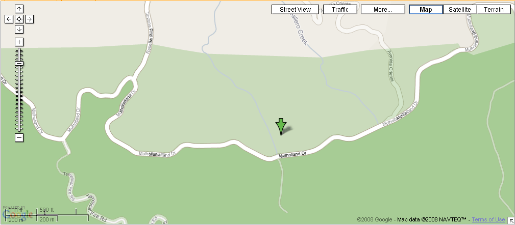
- Los Angeles, California -- Actually in West LA proper, and not too far from 'Dirt' Mulholland in Topanga State Park. Note that in the park, 'Dirt' Mulholland is a fire road and will probably be closed to vehicles. One should be able to hike/bike in from the park boundary, either on the Reseda Blvd trailhead in Tarzana or perhaps from Mulholland Dr. There is a Nike missile silo nearby. Google Maps seems to exist in two different realities as to the geography of the area; see image for details.
- Madison, Wisconsin -- The expedition to the Madison, Wisconsin geohash on 2008-05-24 falls in about 10 miles Northwest of Downtown, in the middle of a field. Definitely doable.
- Mansfield, Ohio -- crap-smack in the middle of nowhere just off a country road. Perfect spot for a meet-up.
- Montgomery, Alabama -- Middle of nowhere, a heavily wooded area next to a stream. It sounds nice enough, let's just hope we don't get chased off by a shotgun. Bring your umbrellas, it looks like rain!
- Munich, Germany -- conveniently located in the middle of the City. Meet-up will happen.
- Nashville, Tennessee -- In a field at the corner of Granny Wright Ln and (a piece of) Stewart's Ferry Pike. Probably private land.
- Newark, New Jersey -- Out in the woods/pine barrens, looks doable: 40.126648°, -74.547534° Also near the northeast border of the Philadelphia, Pennsylvania graticule.
- Newport News, Virginia -- Denbigh High School, on the roof of one of the buildings but you can get close: 37.126648°, -76.547534°
- Palm Beach, Florida -- I'm a recent transplant to the area. Should I worry that today's location is a mile or so south of Alligator Alley? 26.126648°, -80.547534°
- Phoenix, Arizona -- The west valley location is on top of a mountain, so it doesn't look particularly accessible. The east valley location is in Magma, about halfway between Phoenix and Florence a copule hundred feet off the road. Should be accessible.
- Portland, Oregon -- Molalla somewhere, it has been suggested a better meetup would be Monday's coordinates in Vancouver.
- Potsdam, New York -- Bog River Picnic Area, Tupper Lake, New York.
- Rochester, New York -- By the corner of Clover Street and Elmwood Avenue.
- St. Louis, Missouri - Apparently just outside someone's backyard, inside a forest, in De Soto, MO.
- Salt Lake City Utah A good hit for a mostly mountainous graticule. Only 1700ft off the road!
- San Jose, California -- Just outside of Coyote Lake-Harvey Bear Ranch Park, accessible just off 101 near Gilroy/San Martin. Possibly in SCCOSA lands, and about a 400-foot climb up from the lake, but should be able to get close.
- São Paulo, Brazil -- Possibly accessible. Looks like a point near downtown of the city of Atibaia.
- Saskatoon, Saskatchewan - south at College and Highway 5, down ridge road 3045, just south of second farm on East side, middle of that field. Watch out for John Deeres as farmer maybe seeding!!
- Schaumburg, Illinois -- Accessible. Middle of some farm land north west of Route 20 and 72 intersections. Met on the north end of the point along Melms Road. 42.126648°, -88.547534° Read the report here: 2008-05-24 42 -88
- Seattle, Washington - Definitely accessible, public park nearby. Planning to meet at Harry Todd Park. Next to the pier looks like a reasonable place to meet.
- Sheffield, United Kingdom -- Amongst trees near some greenhouses in the hills above Matlock Bath. Successfully reached.
- Springfield, Massachusetts - Actually very convenient. Just east of the tennis courts at Blunt Park in Springfield.
- Tucson, Arizona - In Saguaro National Park-East, 2.5 miles away from nearest road access. [4]
- Vancouver, British Columbia - in the water. However...
- Surrey, British Columbia - coordinates just off the Trans-Canada in Langley. It looks to be right at the boundary between somebody's rear lawn and farmland. The house's address is somewhere from 24380-24399 68 Ave, Langley, BC. Probably just barely beyond the reach of transit.
- Victoria, British Columbia - coordinates are on American soil but probably accessible, not very far from Port Angeles ferry terminal.
- Winnipeg, Manitoba - coordinates are near the egde of a field just off a highway, just north of a small town (Altona).
- Yucca Valley, California - Accessible. Located on the side of a ridge near a wash running north from 29 Palms Highway. Roads extend part way up the wash, the rest of the distance should be an easy hike, bring water.
- Zürich, Switzerland - Accessible. Located in a forest on the Zugerberg, near Zug, Switzerland.
Photo Gallery
- Multi-group meetups with pictures (so far)


Friday 23 May 2008
Coordinates
0.4002468981550087, 0.7227718731909889
Expeditions
2008-05-23 in Boston, Massachusetts graticule -- The coordinates in Boston are on the edge of a large, sandy region next to the Wachusett reservoir, which Randall may attempt to reach if only to figure out just what it is. Perhaps part of a tree farm?
2008-05-23 in Malone graticule -- Glub, glub, it's a scuba meeting for us.
2008-05-23 32 -117 in San Diego, California graticule -- Craig has no boat, no scuba license, and no underwater camera.
2008-05-23 in Ottawa graticule -- We claim this residential parking lot and backyard in the name of XKCD...about 4 blocks from the workplace. Video camera footage to appear on youtube soon.
2008-05-23 in Puerto Rico graticule -- Today's location is only 6 miles from the Arecibo Observatory!
2008-05-23 in Schaumburg, Illinois graticule -- Is in the front yard of an antiques store!
2008-05-23 in Tucson graticule -- Right in the middle of the catalina mountains. Interestingly though, the location happens to be right at the trail head of Palisade Trail on Organization Ridge, with paved road access ending right at it and apparent parking nearby as well. [5]
2008-05-23 Austin, Texas -- Reached by Sigma.
2008-05-23 Amsterdam, The Netherlands -- Reached by Niels.
2008-05-23 in Spokane, Washington graticule -- In a farmers cow pasture not far off Interstate 90.
Baltimore, Maryland - 2008-05-23 39 -76
Mansfield, Ohio - 2008-05-23 40 -82
Thursday 22 May 2008
Coordinates
0.972874275358 0.238696518558
Expeditions
Dayton, Ohio -- The coordinates lie in a field just north of the Dayton Airport.
Edinburgh, Scotland -- The coordinates are in a garden between Crewe Road West and Crewe Road North in Granton.
Lincoln, Nebraska - 2008-05-22 40 -96
Melbourne East, Australia - The coordinates are just off the Monash Freeway, in the suburb that StJimmy lives in.
Minneapolis SW, Minnesota - 2008-05-22 44 -93
San Diego, California - 2008-05-22 32 -117 - The coordinates are just east of the road El Camino Real, south of the Del Mar Horse Park, on what appears to be private, undeveloped property.
Saskatoon, Saskatchewan - The coordinates are between highway 11 and the South Saskatchewan in the woods. There would be bears, ergo, we will try Friday's.
Seattle, Washington -- The coordinates are 2000ft offshore into Puget Sound, west of Everett, WA. The nearest land location is the end of Forest Park, which is accessible by Pigeon Creek Rd (N 47° 58' 12.77", W 122° 13' 48.78" or N 47.970215, W 122.230217)
Stoughton, Wisconsin -- the coordinates were near a road by Lake Kegonsa state park.
Vancouver area:
- Vancouver, British Columbia - The coordinates are in a mountain range between Garibaldi and the Chuckchuck Reserve with no roads.
- Victoria, British Columbia - The coordinates are in the Strait of George halfway along the Sidney-Tsawwassen ferry route. You could get very close to this geohash, in passing, using BC Ferries.
- Bellingham, Washington - The coordinates are in a large field about 10 km south of Abbotsford and a bit east.
Wednesday 21 May 2008
Coordinates
0.17946799469778313, 0.8615360124576236
The sport of Geohashing officially launched with the release of xkcd comic #426 on 21 May 2008.
Graticules with Expeditions
Blacksburg, Virginia -- The coordinates reside in a farm off of VA-42 near Dismal Falls.
Boston, Massachusetts -- The coordinates are in a wooded area to the south of Washington Street (Route 20) near Prospect Street in Auburn, MA. - 2008-05-21 42 -71
Carlisle, United Kingdom -- The coordinates are in the sands of Morecambe Bay, Lancashire. Closest safe location is a beach near a caravan park outside Silverdale.
Chicago, Illinois -- The coordinates are in a farm field to the northeast of Bourbonnais, IL
Houston, Texas -- The coordinates are at the center of the North face of a trapezoidal arrangement of trees, as far from major towns and highways as it is possible to get in this graticule
Los Angeles, California -- The coordinates are at the intersection of Thousand Oaks Blvd. and the southbound CA 23 offramp in Thousand Oaks, CA.
Portland, Oregon -- The coordinates are in a riparian zone near a farm, off of I-5, near Broadacres, OR.
Rochester, New York -- 2008-05-21 43 -77
San Jose, California -- The coordinates are in the mountains of Santa Cruz - 2008-05-21 37 -121
Seattle, Washington -- The coordinates are in the center of a large field at the southern tip of Hartstene Island, which is just north of Olympia.
Plans
User:xkcd will attempt to be the first to reach these coordinates in Boston.
User:zigdon will be heading to the coordinate in San Fransisco Eastern Bay area.
Older Events
View expedition archives for: May 2024 | April 2024 | March 2024 | More...
Known Issues
Several known issues are presented at Known Issues. There is an ongoing discussion on these and other issues at Talk:Main Page.
FAQ
Q: Where is the FAQ page so I can ask a Question?
A: ?
Q: I tried to use the md5sum from my unix/linux command line and the hash was not the same as the comic. What is the correct command line?
A: You probably forgot the "-n" (echo without a newline). Try this to match the example:
echo -n 2005-05-26-10458.68 | md5sum
The md5sum command may be called md5 instead.